Property Record
105 Franklin St, Westerly, RI 02891
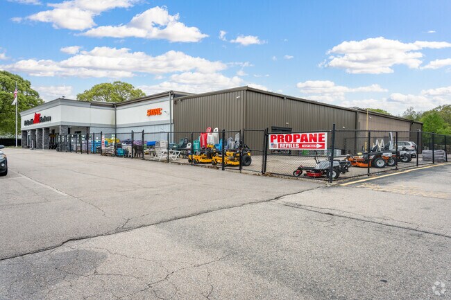

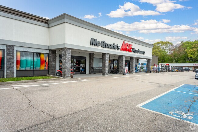
Property Detail
105 Franklin St
WEST-000098-000070A
Washington
Commercialbuilding
Rhode Island
B and X Area of moderate flood hazard, usually the area between the limits of the 100-year and 500-year floods.
a
2025
5.42 AC
2025
Washington County
050802
Providence
30,834 SF
Providence-Warwick, RI-MA
NEARBY LISTINGS FOR SALE OR LEASE
DEMOGRAPHICS near 105 Franklin St
1 mile
3 mile
5 mile
2025 Total Population
3,941
26,319
35,585
2030 Population
3,853
26,203
35,603
Pop Growth 2025-2030
(2.23%)
(0.44%)
+ 0.05%
Average Age
47
46
46
2025 Total Households
1,807
11,761
15,696
HH Growth 2025-2030
(2.49%)
(0.60%)
+ 0.01%
Median Household Inc
$85,063
$91,734
$96,796
Avg Household Size
2.10
2.20
2.20
2025 Avg HH Vehicles
2.00
2.00
2.00
Median Home Value
$419,372
$455,180
$469,002
Median Year Built
1970
1971
1971
Nearby Places
Map Layers
Map Styles
 Street
 Aerial
Layers
 Traffic
 Biking
Places
Listings with unknown addresses are not visible on the map
- Restaurants
- Banks
- Shops
- Fitness
- Groceries
PUBLIC TRANSPORTATION
COMMUTER RAIL
Drive
Walk
Distance
5 min
2.1 mi
Drive
Walk
Distance
16 min
9.7 mi
AIRPORT
Rhode Island Tf Green International
Drive
Walk
Distance
Rhode Island Tf Green International
54 min
38.8 mi
Freight Ports
Port of Davisville, RI
Drive
Walk
Distance
Port of Davisville, RI
53 min
35.0 mi
Nearby Properties
Address
Land Use
TOTAL SIZE
Lot Size
Zoning
Address
Land Use
TOTAL SIZE
Lot Size
Zoning
10.60 AC
Address
Land Use
TOTAL SIZE
Lot Size
Zoning
157,662 SF
27.62 AC
Address
Land Use
TOTAL SIZE
Lot Size
Zoning
181,967 SF
143 AC
RR-80
Address
Land Use
TOTAL SIZE
Lot Size
Zoning
154,316 SF
4.57 AC
Address
Land Use
TOTAL SIZE
Lot Size
Zoning
25.60 AC
Address
Land Use
TOTAL SIZE
Lot Size
Zoning
21.25 AC
Address
Land Use
TOTAL SIZE
Lot Size
Zoning
14.24 AC
Address
Land Use
TOTAL SIZE
Lot Size
Zoning
17,993 SF
13.03 AC
Address
Land Use
TOTAL SIZE
Lot Size
Zoning
96,882 SF
13.12 AC
Address
Land Use
TOTAL SIZE
Lot Size
Zoning
14.71 AC
Address
Land Use
TOTAL SIZE
Lot Size
Zoning
14.04 AC
Address
Land Use
TOTAL SIZE
Lot Size
Zoning
103.50 AC
Address
Land Use
TOTAL SIZE
Lot Size
Zoning
66,003 SF
44.50 AC
GBR-13
Address
Land Use
TOTAL SIZE
Lot Size
Zoning
5,500 SF
14.88 AC
Address
Land Use
TOTAL SIZE
Lot Size
Zoning
2.11 AC
Address
Land Use
TOTAL SIZE
Lot Size
Zoning
117,852 SF
19.78 AC
Address
Land Use
TOTAL SIZE
Lot Size
Zoning
0.55 AC
Address
Land Use
TOTAL SIZE
Lot Size
Zoning
248.11 AC
Address
Land Use
TOTAL SIZE
Lot Size
Zoning
40.80 AC
M-1
Address
Land Use
TOTAL SIZE
Lot Size
Zoning
7.79 AC
Address
Land Use
TOTAL SIZE
Lot Size
Zoning
5,055 SF
24.56 AC
GBR-13
Address
Land Use
TOTAL SIZE
Lot Size
Zoning
32.01 AC
M-1
Address
Land Use
TOTAL SIZE
Lot Size
Zoning
40,705 SF
1.07 AC
Address
Land Use
TOTAL SIZE
Lot Size
Zoning
47,737 SF
9.96 AC
Address
Land Use
TOTAL SIZE
Lot Size
Zoning
31,018 SF
4.05 AC
Address
Land Use
TOTAL SIZE
Lot Size
Zoning
60,968 SF
8 AC
RA-15
Address
Land Use
TOTAL SIZE
Lot Size
Zoning
7.65 AC
Address
Land Use
TOTAL SIZE
Lot Size
Zoning
28,760 SF
Address
Land Use
TOTAL SIZE
Lot Size
Zoning
142.05 AC
Address
Land Use
TOTAL SIZE
Lot Size
Zoning
121,068 SF
2.53 AC
M-1
The World's #1 Commercial Real Estate Marketplace
Connect with us
© 2026 CoStar Group
The information above has been obtained from sources believed reliable. While we do not doubt its accuracy we have not verified it and make no guarantee, warranty or representation about it. It is your responsibility to independently confirm its accuracy and completeness. Any projections, opinions, assumptions, or estimates used are for example only and do not represent the current or future performance of the property. The value of this transaction to you depends on tax and other factors which should be evaluated by your tax, financial, and legal advisors. You and your advisors should conduct a careful, independent investigation of the property to determine to your satisfaction the suitability of the property for your needs.