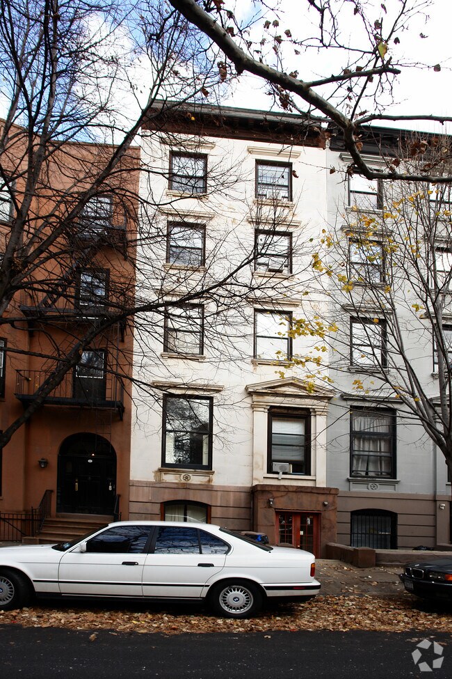
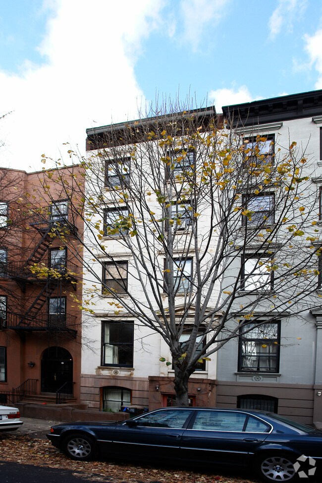
Property Record
105 Joralemon St, Brooklyn, NY 11201

NEARBY LISTINGS FOR SALE OR LEASE
-
-
-
-
-
-
-
-
-
No Photo
-
-
-
-
-
-
-
-
-
-
-
-
-
-
-
-
-
-
-
-
-
-
View all Brooklyn listings for sale on LoopNet.com
Property Detail
105 Joralemon St
00253-0005
Kings
Multifamilydwelling
New York
X
5
3604970203F
0.05 AC
2024
Brooklyn Heights
2025
Long Island (New York)
000501
New York-Jersey City-White Plains, NY-NJ
5,510 SF
DEMOGRAPHICS near 105 Joralemon St
1 Mile
3 Mile
5 Mile
2024 Total Population
118,031
1,001,572
2,650,016
2029 Population
114,232
950,181
2,499,811
Pop Growth 2024-2029
(3.22%)
(5.13%)
(5.67%)
Average Age
38
38
38
2024 Total Households
54,581
442,246
1,109,228
HH Growth 2024-2029
(3.53%)
(5.53%)
(5.95%)
Median Household Inc
$137,218
$102,725
$87,991
Avg Household Size
2.10
2.10
2.30
2024 Avg HH Vehicles
.00
.00
.00
Median Home Value
$1,042,998
$1,020,229
$906,791
Median Year Built
1956
1949
1949
Nearby Places
Map Layers
Map Styles
 Street
 Aerial
- Restaurants
- Banks
- Shops
- Fitness
- Groceries
PUBLIC TRANSPORTATION
TRANSIT/SUBWAY
Clark Street (2 - New York MTA Subway (The Subway), 3 - New York MTA Subway (The Subway))
DRIVE
WALK
Distance
Clark Street (2 - New York MTA Subway (The Subway), 3 - New York MTA Subway (The Subway))
3 min
6 min
0.3 mi
Borough Hall-Court Street (2 - New York MTA Subway (The Subway), 3 - New York MTA Subway (The Subway), 4 - New York MTA Subway (The Subway), 5 - New York MTA Subway (The Subway), M - New York MTA Subway (The Subway), N - New York MTA Subway (The Subway), R - New York MTA Subway (The Subway))
DRIVE
WALK
Distance
Borough Hall-Court Street (2 - New York MTA Subway (The Subway), 3 - New York MTA Subway (The Subway), 4 - New York MTA Subway (The Subway), 5 - New York MTA Subway (The Subway), M - New York MTA Subway (The Subway), N - New York MTA Subway (The Subway), R - New York MTA Subway (The Subway))
3 min
6 min
0.3 mi
Jay Street-Borough Hall (A - New York MTA Subway (The Subway), C - New York MTA Subway (The Subway), F - New York MTA Subway (The Subway))
DRIVE
WALK
Distance
Jay Street-Borough Hall (A - New York MTA Subway (The Subway), C - New York MTA Subway (The Subway), F - New York MTA Subway (The Subway))
3 min
10 min
0.5 mi
Lawrence Street-MetroTech (M - New York MTA Subway (The Subway), N - New York MTA Subway (The Subway), R - New York MTA Subway (The Subway))
DRIVE
WALK
Distance
Lawrence Street-MetroTech (M - New York MTA Subway (The Subway), N - New York MTA Subway (The Subway), R - New York MTA Subway (The Subway))
4 min
10 min
0.5 mi
High Street (A - New York MTA Subway (The Subway), C - New York MTA Subway (The Subway))
DRIVE
WALK
Distance
High Street (A - New York MTA Subway (The Subway), C - New York MTA Subway (The Subway))
4 min
12 min
0.6 mi
COMMUTER RAIL
DRIVE
WALK
Distance
6 min
1.6 mi
Nostrand Avenue Station (Far Rockaway Branch - Long Island Rail Road, Hempstead Branch - Long Island Rail Road, Long Beach Branch - Long Island Rail Road, West Hempstead Branch - Long Island Rail Road)
DRIVE
WALK
Distance
Nostrand Avenue Station (Far Rockaway Branch - Long Island Rail Road, Hempstead Branch - Long Island Rail Road, Long Beach Branch - Long Island Rail Road, West Hempstead Branch - Long Island Rail Road)
10 min
3.0 mi
AIRPORT
LaGuardia
DRIVE
WALK
Distance
LaGuardia
21 min
11.1 mi
Newark Liberty International
DRIVE
WALK
Distance
Newark Liberty International
27 min
15.3 mi
John F Kennedy International
DRIVE
WALK
Distance
John F Kennedy International
30 min
19.3 mi
Freight Ports
NY - Red Hook Container Terminal
DRIVE
WALK
Distance
NY - Red Hook Container Terminal
3 min
1.0 mi
Nearby Properties
Address
Land Use
TOTAL SIZE
Lot Size
Zoning
Address
Land Use
TOTAL SIZE
Lot Size
Zoning
8,462,176 SF
61.41 AC
R7-2
Address
Land Use
TOTAL SIZE
Lot Size
Zoning
2,354,289 SF
3.96 AC
C6-4
Address
Land Use
TOTAL SIZE
Lot Size
Zoning
2,812,739 SF
2.10 AC
C5-3
Address
Land Use
TOTAL SIZE
Lot Size
Zoning
2.38 AC
Address
Land Use
TOTAL SIZE
Lot Size
Zoning
1.75 AC
Address
Land Use
TOTAL SIZE
Lot Size
Zoning
2,157,862 SF
2.23 AC
BPC
Address
Land Use
TOTAL SIZE
Lot Size
Zoning
1,009,855 SF
4.90 AC
C6-3
Address
Land Use
TOTAL SIZE
Lot Size
Zoning
2,255,659 SF
4.58 AC
BPC
Address
Land Use
TOTAL SIZE
Lot Size
Zoning
Address
Land Use
TOTAL SIZE
Lot Size
Zoning
1,009,855 SF
3.25 AC
C6-3
Address
Land Use
TOTAL SIZE
Lot Size
Zoning
6.42 AC
Address
Land Use
TOTAL SIZE
Lot Size
Zoning
2,233,692 SF
1.90 AC
BPC
Address
Land Use
TOTAL SIZE
Lot Size
Zoning
2.21 AC
Address
Land Use
TOTAL SIZE
Lot Size
Zoning
1,104,505 SF
2.32 AC
C4-7
Address
Land Use
TOTAL SIZE
Lot Size
Zoning
1,636,000 SF
1.09 AC
C6-4
Address
Land Use
TOTAL SIZE
Lot Size
Zoning
1,909,502 SF
2.37 AC
BPC
Address
Land Use
TOTAL SIZE
Lot Size
Zoning
940,000 SF
1.44 AC
C6-2
Address
Land Use
TOTAL SIZE
Lot Size
Zoning
1,780,030 SF
5.07 AC
BPC
Address
Land Use
TOTAL SIZE
Lot Size
Zoning
7,058,736 SF
147.61 AC
M3-1
Address
Land Use
TOTAL SIZE
Lot Size
Zoning
869,038 SF
1.53 AC
M1-1
Address
Land Use
TOTAL SIZE
Lot Size
Zoning
1.04 AC
Address
Land Use
TOTAL SIZE
Lot Size
Zoning
1,260,362 SF
4.32 AC
C1-7
Address
Land Use
TOTAL SIZE
Lot Size
Zoning
1.87 AC
I-2
Address
Land Use
TOTAL SIZE
Lot Size
Zoning
1.84 AC
Address
Land Use
TOTAL SIZE
Lot Size
Zoning
11.15 AC
Address
Land Use
TOTAL SIZE
Lot Size
Zoning
92,440 SF
466.23 AC
R5
Address
Land Use
TOTAL SIZE
Lot Size
Zoning
802,000 SF
1.20 AC
C62A
Address
Land Use
TOTAL SIZE
Lot Size
Zoning
3,122,165 SF
19.02 AC
R7-2
Address
Land Use
TOTAL SIZE
Lot Size
Zoning
2,210,200 SF
2.58 AC
C5-5
Address
Land Use
TOTAL SIZE
Lot Size
Zoning
1,362,190 SF
C5-5
The World's #1 Commercial Real Estate Marketplace
Connect with us
© 2025 CoStar Group
The information above has been obtained from sources believed reliable. While we do not doubt its accuracy we have not verified it and make no guarantee, warranty or representation about it. It is your responsibility to independently confirm its accuracy and completeness. Any projections, opinions, assumptions, or estimates used are for example only and do not represent the current or future performance of the property. The value of this transaction to you depends on tax and other factors which should be evaluated by your tax, financial, and legal advisors. You and your advisors should conduct a careful, independent investigation of the property to determine to your satisfaction the suitability of the property for your needs.