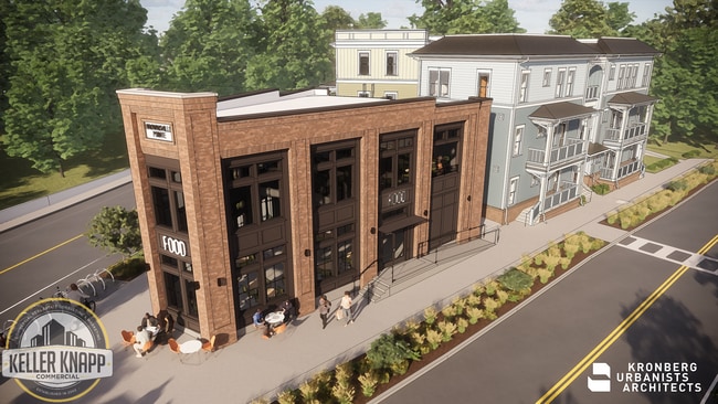
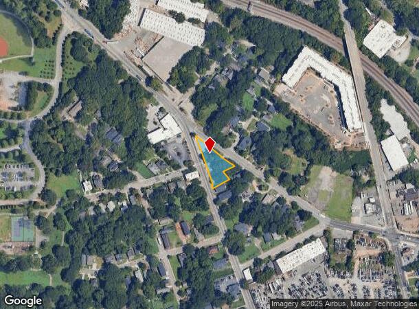
Property Record
105 Mcdonough Blvd Se, Atlanta, GA 30315
NEARBY LISTINGS FOR SALE OR LEASE
Property Detail
105 Mcdonough Blvd Se
14-0056-0005-061-1
KA VACANT LAND F/C 4/16/25 BLDG DEMO, LD IN PROGRESS CB26 FOR NC
Commercialacreage
Fulton
X
Georgia
13121C0357F
0.33 AC
2024
SE Atlanta
2025
Atlanta
005504
Atlanta-Sandy Springs-Roswell, GA
1,204 SF
DEMOGRAPHICS near 105 Mcdonough Blvd Se
1 Mile
3 Mile
5 Mile
2024 Total Population
15,915
124,543
333,772
2029 Population
16,962
130,072
346,333
Pop Growth 2024-2029
+ 6.58%
+ 4.44%
+ 3.76%
Average Age
36
36
37
2024 Total Households
6,061
51,435
148,679
HH Growth 2024-2029
+ 7.19%
+ 4.86%
+ 4.00%
Median Household Inc
$39,773
$55,838
$67,266
Avg Household Size
2.30
2.10
2.00
2024 Avg HH Vehicles
1.00
1.00
1.00
Median Home Value
$324,615
$353,774
$360,753
Median Year Built
1998
1979
1982
Nearby Places
- Restaurants
- Banks
- Shops
- Fitness
- Groceries
PUBLIC TRANSPORTATION
COMMUTER RAIL
Atlanta (Crescent - Amtrak)
DRIVE
WALK
Distance
Atlanta (Crescent - Amtrak)
11 min
7.0 mi
AIRPORT
Hartsfield - Jackson Atlanta International
DRIVE
WALK
Distance
Hartsfield - Jackson Atlanta International
13 min
7.7 mi
Freight Ports
Georgia Ports - Savannah
DRIVE
WALK
Distance
Georgia Ports - Savannah
276 min
244.8 mi
SALE & LEASE HISTORY
LISTING DATE
SALE/LEASE

Feb 18, 2025
For Lease
Feb 05, 2024
For Lease
Nearby Properties
Address
Land Use
TOTAL SIZE
Lot Size
Zoning
Address
Land Use
TOTAL SIZE
Lot Size
Zoning
19.94 AC
SPI1
Address
Land Use
TOTAL SIZE
Lot Size
Zoning
11.74 AC
I1
Address
Land Use
TOTAL SIZE
Lot Size
Zoning
9.80 AC
C5
Address
Land Use
TOTAL SIZE
Lot Size
Zoning
3.16 AC
SPI1
Address
Land Use
TOTAL SIZE
Lot Size
Zoning
1,300,309 SF
4.81 AC
SPI1
Address
Land Use
TOTAL SIZE
Lot Size
Zoning
1,434,872 SF
1.89 AC
SPI1
Address
Land Use
TOTAL SIZE
Lot Size
Zoning
61.57 AC
C5
Address
Land Use
TOTAL SIZE
Lot Size
Zoning
1.55 AC
SPI1
Address
Land Use
TOTAL SIZE
Lot Size
Zoning
7 AC
C3
Address
Land Use
TOTAL SIZE
Lot Size
Zoning
2,577,342 SF
2.04 AC
SPI1
Address
Land Use
TOTAL SIZE
Lot Size
Zoning
13,340,229 SF
3.68 AC
SPI1
Address
Land Use
TOTAL SIZE
Lot Size
Zoning
1,589,465 SF
3.41 AC
SPI1
Address
Land Use
TOTAL SIZE
Lot Size
Zoning
3.62 AC
SPI1
Address
Land Use
TOTAL SIZE
Lot Size
Zoning
543,748 SF
3.86 AC
I2
Address
Land Use
TOTAL SIZE
Lot Size
Zoning
3,588,720 SF
1.32 AC
SPI1
Address
Land Use
TOTAL SIZE
Lot Size
Zoning
631,858 SF
1.33 AC
C5C
Address
Land Use
TOTAL SIZE
Lot Size
Zoning
1,975,400 SF
9.58 AC
RG4
Address
Land Use
TOTAL SIZE
Lot Size
Zoning
432,056 SF
17.87 AC
C1
Address
Land Use
TOTAL SIZE
Lot Size
Zoning
510,561 SF
87 SF
SPI1
Address
Land Use
TOTAL SIZE
Lot Size
Zoning
34 AC
OI
Address
Land Use
TOTAL SIZE
Lot Size
Zoning
1,553,747 SF
2 AC
SPI1
Address
Land Use
TOTAL SIZE
Lot Size
Zoning
400,311 SF
4.45 AC
I2
Address
Land Use
TOTAL SIZE
Lot Size
Zoning
541,092 SF
0.53 AC
SPI1
Address
Land Use
TOTAL SIZE
Lot Size
Zoning
498,515 SF
3.41 AC
C1
Address
Land Use
TOTAL SIZE
Lot Size
Zoning
595,658 SF
4.09 AC
I1
Address
Land Use
TOTAL SIZE
Lot Size
Zoning
632,090 SF
1.01 AC
SPI1
Address
Land Use
TOTAL SIZE
Lot Size
Zoning
351,438 SF
0.44 AC
SPI1
Address
Land Use
TOTAL SIZE
Lot Size
Zoning
0.45 AC
SPI1
Address
Land Use
TOTAL SIZE
Lot Size
Zoning
979,670 SF
0.82 AC
SPI1
Address
Land Use
TOTAL SIZE
Lot Size
Zoning
529,576 SF
1.47 AC
SPI1
The World's #1 Commercial Real Estate Marketplace
Connect with us
© 2025 CoStar Group
The information above has been obtained from sources believed reliable. While we do not doubt its accuracy we have not verified it and make no guarantee, warranty or representation about it. It is your responsibility to independently confirm its accuracy and completeness. Any projections, opinions, assumptions, or estimates used are for example only and do not represent the current or future performance of the property. The value of this transaction to you depends on tax and other factors which should be evaluated by your tax, financial, and legal advisors. You and your advisors should conduct a careful, independent investigation of the property to determine to your satisfaction the suitability of the property for your needs.