Property Record
107 N 2Nd St, Rockport, IN 47635
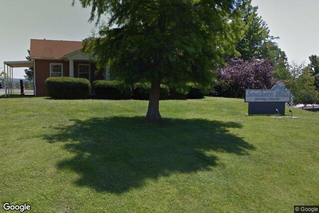
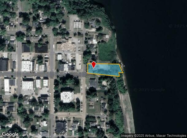
This Property Is For Sale
NEARBY LISTINGS FOR SALE OR LEASE
-
-
View all Rockport listings for sale on LoopNet.com
Property Detail
107 N 2Nd St
74-15-26-102-015.000-018
Hynes Donation
Officebuilding
HYNES - 0.82 A
AE
Spencer
21059C0045E
Indiana
2024
0.76 AC
2024
Indiana South Area
953100
Other Market Areas
2,464 SF
DEMOGRAPHICS near 107 N 2Nd St
1 Mile
3 Mile
5 Mile
2024 Total Population
2,305
3,112
8,071
2029 Population
2,395
3,225
8,319
Pop Growth 2024-2029
+ 3.90%
+ 3.63%
+ 3.07%
Average Age
43
43
41
2024 Total Households
1,014
1,354
3,236
HH Growth 2024-2029
+ 3.94%
+ 3.69%
+ 3.09%
Median Household Inc
$47,358
$48,499
$53,159
Avg Household Size
2.20
2.20
2.40
2024 Avg HH Vehicles
2.00
2.00
2.00
Median Home Value
$135,391
$139,534
$145,536
Median Year Built
1968
1969
1977
Nearby Places
Map Layers
Map Styles
 Street
 Aerial
- Restaurants
- Banks
- Shops
- Fitness
- Groceries
PUBLIC TRANSPORTATION
AIRPORT
Evansville Regional
DRIVE
WALK
Distance
Evansville Regional
54 min
34.7 mi
Freight Ports
Port of Toledo
DRIVE
WALK
Distance
Port of Toledo
459 min
399.5 mi
Nearby Properties
Address
Land Use
TOTAL SIZE
Lot Size
Zoning
Address
Land Use
TOTAL SIZE
Lot Size
Zoning
5,670 SF
236.33 AC
I2
Address
Land Use
TOTAL SIZE
Lot Size
Zoning
7,284 SF
316.89 AC
I2
Address
Land Use
TOTAL SIZE
Lot Size
Zoning
59,532 SF
92.59 AC
Address
Land Use
TOTAL SIZE
Lot Size
Zoning
1,422 SF
58.66 AC
Address
Land Use
TOTAL SIZE
Lot Size
Zoning
31,855 SF
2 AC
Address
Land Use
TOTAL SIZE
Lot Size
Zoning
4.01 AC
Address
Land Use
TOTAL SIZE
Lot Size
Zoning
24,332 SF
0.61 AC
Address
Land Use
TOTAL SIZE
Lot Size
Zoning
154.22 AC
I2
Address
Land Use
TOTAL SIZE
Lot Size
Zoning
7,533 SF
1.98 AC
Address
Land Use
TOTAL SIZE
Lot Size
Zoning
18,065 SF
16.93 AC
I1
Address
Land Use
TOTAL SIZE
Lot Size
Zoning
6,929 SF
1.70 AC
Address
Land Use
TOTAL SIZE
Lot Size
Zoning
2,344 SF
643.05 AC
Address
Land Use
TOTAL SIZE
Lot Size
Zoning
14,080 SF
5 AC
I1
Address
Land Use
TOTAL SIZE
Lot Size
Zoning
6,000 SF
2.82 AC
I1
Address
Land Use
TOTAL SIZE
Lot Size
Zoning
9,196 SF
1.20 AC
Address
Land Use
TOTAL SIZE
Lot Size
Zoning
81.35 AC
I-2
Address
Land Use
TOTAL SIZE
Lot Size
Zoning
28,097 SF
1.85 AC
Address
Land Use
TOTAL SIZE
Lot Size
Zoning
26,059 SF
4.29 AC
Address
Land Use
TOTAL SIZE
Lot Size
Zoning
1,744 SF
460.34 AC
Address
Land Use
TOTAL SIZE
Lot Size
Zoning
22,650 SF
0.89 AC
Address
Land Use
TOTAL SIZE
Lot Size
Zoning
3,540 SF
4.29 AC
I1
Address
Land Use
TOTAL SIZE
Lot Size
Zoning
14,925 SF
6.16 AC
I1
Address
Land Use
TOTAL SIZE
Lot Size
Zoning
15,313 SF
0.24 AC
Address
Land Use
TOTAL SIZE
Lot Size
Zoning
5,823 SF
5.61 AC
R1
Address
Land Use
TOTAL SIZE
Lot Size
Zoning
1,692 SF
305.54 AC
Address
Land Use
TOTAL SIZE
Lot Size
Zoning
156.23 AC
R1
Address
Land Use
TOTAL SIZE
Lot Size
Zoning
155.90 AC
A
Address
Land Use
TOTAL SIZE
Lot Size
Zoning
6,464 SF
1.24 AC
Address
Land Use
TOTAL SIZE
Lot Size
Zoning
255.10 AC
Address
Land Use
TOTAL SIZE
Lot Size
Zoning
439.55 AC
The World's #1 Commercial Real Estate Marketplace
Connect with us
© 2026 CoStar Group
The information above has been obtained from sources believed reliable. While we do not doubt its accuracy we have not verified it and make no guarantee, warranty or representation about it. It is your responsibility to independently confirm its accuracy and completeness. Any projections, opinions, assumptions, or estimates used are for example only and do not represent the current or future performance of the property. The value of this transaction to you depends on tax and other factors which should be evaluated by your tax, financial, and legal advisors. You and your advisors should conduct a careful, independent investigation of the property to determine to your satisfaction the suitability of the property for your needs.