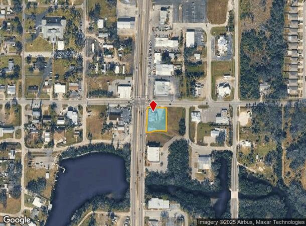
Property Record
105 N 41 Hwy, Ruskin, FL 33570
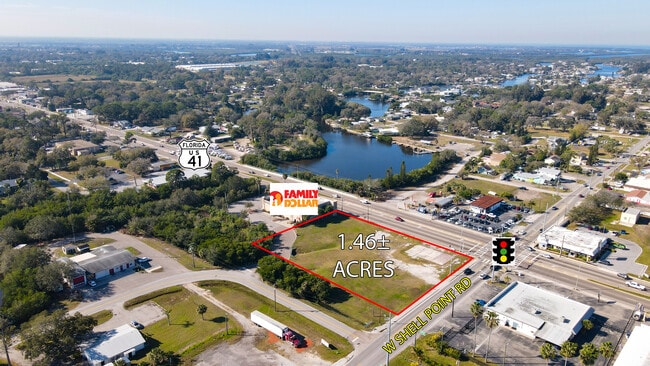
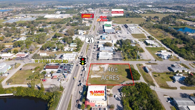
This Property Is For Sale
NEARBY LISTINGS FOR SALE OR LEASE
Property Detail
105 N 41 Hwy
Tampa-St. Petersburg-Clearwater, FL
Ruskin City Map Of
U-08-32-19-1V5-000000-00086.0
RUSKIN CITY MAP OF LOT 86 LESS R/W---N 1/2 OF VAC NE 1ST AVE ABUTTING S BDRY THEREOF
Commercialacreage
Hillsborough
AE
Florida
12057C0656J
86
2024
0.51 AC
2024
Southeast Hillsborough
014108
Tampa/St Petersburg
4,915 SF
DEMOGRAPHICS near 105 N 41 Hwy
1 Mile
3 Mile
5 Mile
2024 Total Population
7,830
44,573
87,327
2029 Population
8,805
50,227
98,301
Pop Growth 2024-2029
+ 12.45%
+ 12.68%
+ 12.57%
Average Age
37
39
47
2024 Total Households
2,665
15,569
35,362
HH Growth 2024-2029
+ 12.76%
+ 12.83%
+ 12.74%
Median Household Inc
$77,279
$78,064
$70,747
Avg Household Size
2.90
2.80
2.40
2024 Avg HH Vehicles
2.00
2.00
2.00
Median Home Value
$264,861
$266,770
$263,561
Median Year Built
2006
2008
2003
Nearby Places
- Restaurants
- Banks
- Shops
- Fitness
- Groceries
PUBLIC TRANSPORTATION
AIRPORT
Sarasota/Bradenton International
DRIVE
WALK
Distance
Sarasota/Bradenton International
43 min
27.7 mi
Tampa International
DRIVE
WALK
Distance
Tampa International
46 min
28.9 mi
St Pete-Clearwater International
DRIVE
WALK
Distance
St Pete-Clearwater International
62 min
44.2 mi
Nearby Properties
Address
Land Use
TOTAL SIZE
Lot Size
Zoning
Address
Land Use
TOTAL SIZE
Lot Size
Zoning
1,026,563 SF
79.54 AC
PD
Address
Land Use
TOTAL SIZE
Lot Size
Zoning
351,758 SF
63.45 AC
PD
Address
Land Use
TOTAL SIZE
Lot Size
Zoning
290,432 SF
45.44 AC
PD
Address
Land Use
TOTAL SIZE
Lot Size
Zoning
190,908 SF
49.11 AC
PD
Address
Land Use
TOTAL SIZE
Lot Size
Zoning
132,036 SF
3.30 AC
PD
Address
Land Use
TOTAL SIZE
Lot Size
Zoning
77,315 SF
9.71 AC
CG
Address
Land Use
TOTAL SIZE
Lot Size
Zoning
478.28 AC
PD
Address
Land Use
TOTAL SIZE
Lot Size
Zoning
94,955 SF
13.55 AC
PD
Address
Land Use
TOTAL SIZE
Lot Size
Zoning
58,368 SF
9.15 AC
PD
Address
Land Use
TOTAL SIZE
Lot Size
Zoning
137,465 SF
10.30 AC
PD
Address
Land Use
TOTAL SIZE
Lot Size
Zoning
131,647 SF
9.98 AC
PD
Address
Land Use
TOTAL SIZE
Lot Size
Zoning
51,900 SF
47.60 AC
PD
Address
Land Use
TOTAL SIZE
Lot Size
Zoning
61,680 SF
20.16 AC
PD
Address
Land Use
TOTAL SIZE
Lot Size
Zoning
1,325 SF
2.69 AC
PD
Address
Land Use
TOTAL SIZE
Lot Size
Zoning
89,847 SF
8.56 AC
PD
Address
Land Use
TOTAL SIZE
Lot Size
Zoning
131,155 SF
18.31 AC
PD
Address
Land Use
TOTAL SIZE
Lot Size
Zoning
41,031 SF
12.16 AC
CN
Address
Land Use
TOTAL SIZE
Lot Size
Zoning
119,624 SF
13.03 AC
M
Address
Land Use
TOTAL SIZE
Lot Size
Zoning
97,398 SF
12.45 AC
RDC-12
Address
Land Use
TOTAL SIZE
Lot Size
Zoning
54,228 SF
2.85 AC
PD
Address
Land Use
TOTAL SIZE
Lot Size
Zoning
33,080 SF
7.58 AC
PD
Address
Land Use
TOTAL SIZE
Lot Size
Zoning
90,750 SF
5.83 AC
PD
Address
Land Use
TOTAL SIZE
Lot Size
Zoning
36.50 AC
PD
Address
Land Use
TOTAL SIZE
Lot Size
Zoning
6,768 SF
47.53 AC
PD
Address
Land Use
TOTAL SIZE
Lot Size
Zoning
129,728 SF
23.85 AC
PD
Address
Land Use
TOTAL SIZE
Lot Size
Zoning
861 SF
3.74 AC
PD
Address
Land Use
TOTAL SIZE
Lot Size
Zoning
41,310 SF
8.70 AC
PD
Address
Land Use
TOTAL SIZE
Lot Size
Zoning
118.69 AC
AR
Address
Land Use
TOTAL SIZE
Lot Size
Zoning
25,095 SF
24.54 AC
PD
Address
Land Use
TOTAL SIZE
Lot Size
Zoning
7,886 SF
344.76 AC
AR
The World's #1 Commercial Real Estate Marketplace
Connect with us
© 2025 CoStar Group
The information above has been obtained from sources believed reliable. While we do not doubt its accuracy we have not verified it and make no guarantee, warranty or representation about it. It is your responsibility to independently confirm its accuracy and completeness. Any projections, opinions, assumptions, or estimates used are for example only and do not represent the current or future performance of the property. The value of this transaction to you depends on tax and other factors which should be evaluated by your tax, financial, and legal advisors. You and your advisors should conduct a careful, independent investigation of the property to determine to your satisfaction the suitability of the property for your needs.