Property Record
105 Peach State Ct, Tyrone, GA 30290
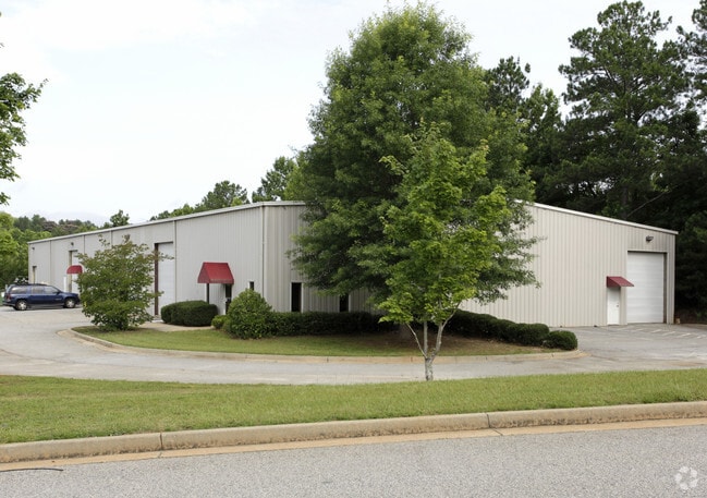

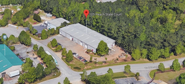
Property Detail
105 Peach State Ct
07-44-01-007
LOT 7 SHAMROCK IND PARK V
Warehouse
Fayette
I M1
Georgia
B and X Area of moderate flood hazard, usually the area between the limits of the 100-year and 500-year floods.
7
2025
1.38 AC
2025
Fayette/Coweta County
140210
Atlanta
17,100 SF
Atlanta-Sandy Springs-Roswell, GA
NEARBY LISTINGS FOR SALE OR LEASE
DEMOGRAPHICS near 105 Peach State Ct
1 mile
3 mile
5 mile
2025 Total Population
3,118
30,443
62,856
2030 Population
3,296
31,745
65,709
Pop Growth 2025-2030
+ 5.71%
+ 4.28%
+ 4.54%
Average Age
42
43
42
2025 Total Households
1,169
11,130
22,566
HH Growth 2025-2030
+ 5.73%
+ 4.23%
+ 4.52%
Median Household Inc
$113,586
$119,453
$119,159
Avg Household Size
2.70
2.70
2.80
2025 Avg HH Vehicles
2.00
2.00
2.00
Median Home Value
$625,440
$489,615
$466,978
Median Year Built
2007
1996
1994
Nearby Places
Map Layers
Map Styles
 Street
 Aerial
Layers
 Traffic
 Biking
Places
Listings with unknown addresses are not visible on the map
- Restaurants
- Banks
- Shops
- Fitness
- Groceries
PUBLIC TRANSPORTATION
AIRPORT
Hartsfield - Jackson Atlanta International
Drive
Walk
Distance
Hartsfield - Jackson Atlanta International
35 min
23.0 mi
Freight Ports
Georgia Ports - Savannah
Drive
Walk
Distance
Georgia Ports - Savannah
292 min
247.5 mi
SALE & LEASE HISTORY
LISTING DATE
SALE/LEASE

Oct 18, 2018
For Lease
Nearby Properties
Address
Land Use
TOTAL SIZE
Lot Size
Zoning
Address
Land Use
TOTAL SIZE
Lot Size
Zoning
171,535 SF
27.60 AC
C GC
Address
Land Use
TOTAL SIZE
Lot Size
Zoning
194,839 SF
25.40 AC
C GC
Address
Land Use
TOTAL SIZE
Lot Size
Zoning
118,729 SF
21.25 AC
C GR10
Address
Land Use
TOTAL SIZE
Lot Size
Zoning
218,763 SF
38.40 AC
C GC
Address
Land Use
TOTAL SIZE
Lot Size
Zoning
145,198 SF
52.44 AC
R1
Address
Land Use
TOTAL SIZE
Lot Size
Zoning
102,516 SF
19.60 AC
Address
Land Use
TOTAL SIZE
Lot Size
Zoning
75,217 SF
15 AC
CS
Address
Land Use
TOTAL SIZE
Lot Size
Zoning
39,195 SF
14.06 AC
C GC
Address
Land Use
TOTAL SIZE
Lot Size
Zoning
202,691 SF
24.65 AC
C GC
Address
Land Use
TOTAL SIZE
Lot Size
Zoning
96,409 SF
12.74 AC
C GC
Address
Land Use
TOTAL SIZE
Lot Size
Zoning
32,126 SF
8.41 AC
C LUC
Address
Land Use
TOTAL SIZE
Lot Size
Zoning
230.80 AC
Address
Land Use
TOTAL SIZE
Lot Size
Zoning
153,191 SF
20.95 AC
R1
Address
Land Use
TOTAL SIZE
Lot Size
Zoning
59,250 SF
8.77 AC
R1
Address
Land Use
TOTAL SIZE
Lot Size
Zoning
93,925 SF
5.18 AC
C GC
Address
Land Use
TOTAL SIZE
Lot Size
Zoning
80,956 SF
60.90 AC
Address
Land Use
TOTAL SIZE
Lot Size
Zoning
14,166 SF
5.05 AC
C GC
Address
Land Use
TOTAL SIZE
Lot Size
Zoning
137,702 SF
17.39 AC
R1
Address
Land Use
TOTAL SIZE
Lot Size
Zoning
27,820 SF
4.01 AC
C GC
Address
Land Use
TOTAL SIZE
Lot Size
Zoning
47,555 SF
20.10 AC
AR
Address
Land Use
TOTAL SIZE
Lot Size
Zoning
125,421 SF
12.99 AC
C GC
Address
Land Use
TOTAL SIZE
Lot Size
Zoning
43,812 SF
10 AC
C GR10
Address
Land Use
TOTAL SIZE
Lot Size
Zoning
31,490 SF
2.48 AC
C GC
Address
Land Use
TOTAL SIZE
Lot Size
Zoning
14,636 SF
6.50 AC
C OI
Address
Land Use
TOTAL SIZE
Lot Size
Zoning
52,615 SF
4.15 AC
C LUC
Address
Land Use
TOTAL SIZE
Lot Size
Zoning
75,847 SF
15.82 AC
R1
Address
Land Use
TOTAL SIZE
Lot Size
Zoning
35,455 SF
2.30 AC
C GC
Address
Land Use
TOTAL SIZE
Lot Size
Zoning
26,327 SF
2.84 AC
C LUC
Address
Land Use
TOTAL SIZE
Lot Size
Zoning
36,900 SF
8.12 AC
C OI
Address
Land Use
TOTAL SIZE
Lot Size
Zoning
41,262 SF
3 AC
C LUC
The World's #1 Commercial Real Estate Marketplace
Connect with us
© 2026 CoStar Group
The information above has been obtained from sources believed reliable. While we do not doubt its accuracy we have not verified it and make no guarantee, warranty or representation about it. It is your responsibility to independently confirm its accuracy and completeness. Any projections, opinions, assumptions, or estimates used are for example only and do not represent the current or future performance of the property. The value of this transaction to you depends on tax and other factors which should be evaluated by your tax, financial, and legal advisors. You and your advisors should conduct a careful, independent investigation of the property to determine to your satisfaction the suitability of the property for your needs.