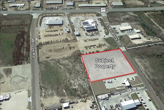
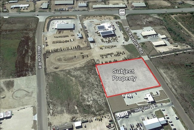
Property Record
105 S Aviator Rd, Laredo, TX 78043

Property Detail
105 S Aviator Rd
Laredo, TX
LAS LOMAS INDUSTRIAL PARK, BLOCK 2, LOT 3, PHASE I
459415
WEBB
Residentialacreage
Texas
B and X Area of moderate flood hazard, usually the area between the limits of the 100-year and 500-year floods.
3
2024
2.92 AC
2025
Texas South Area
001826
Other Market Areas
NEARBY LISTINGS FOR SALE OR LEASE
DEMOGRAPHICS near 105 S Aviator Rd
1 mile
3 mile
5 mile
2025 Total Population
1,143
19,487
88,076
2030 Population
1,207
20,143
90,170
Pop Growth 2025-2030
+ 5.60%
+ 3.37%
+ 2.38%
Average Age
30
31
33
2025 Total Households
281
5,179
24,523
HH Growth 2025-2030
+ 6.05%
+ 3.53%
+ 2.50%
Median Household Inc
$49,860
$81,904
$56,669
Avg Household Size
3.90
3.70
3.50
2025 Avg HH Vehicles
2.00
2.00
2.00
Median Home Value
$182,812
$210,758
$178,024
Median Year Built
2001
2004
1997
Nearby Places
Map Layers
Map Styles
 Street
 Aerial
Transit
 Traffic
 Biking
Places
Listings with unknown addresses are not visible on the map
- Restaurants
- Banks
- Shops
- Fitness
- Groceries
PUBLIC TRANSPORTATION
AIRPORT
Laredo International
Drive
Walk
Distance
Laredo International
11 min
6.7 mi
Freight Ports
Port of Corpus Christi
Drive
Walk
Distance
Port of Corpus Christi
164 min
143.1 mi
SALE & LEASE HISTORY
LISTING DATE
SALE/LEASE

May 20, 2025
For Sale
Mar 23, 2017
For Sale
Nearby Properties
Address
Land Use
TOTAL SIZE
Lot Size
Zoning
Address
Land Use
TOTAL SIZE
Lot Size
Zoning
310,346 SF
87.65 AC
R1A
Address
Land Use
TOTAL SIZE
Lot Size
Zoning
347,773 SF
49.74 AC
R1
Address
Land Use
TOTAL SIZE
Lot Size
Zoning
380,420 SF
9.18 AC
B3
Address
Land Use
TOTAL SIZE
Lot Size
Zoning
95,769 SF
10 AC
R1
Address
Land Use
TOTAL SIZE
Lot Size
Zoning
70,843 SF
20 AC
Address
Land Use
TOTAL SIZE
Lot Size
Zoning
81,470 SF
36.89 AC
Address
Land Use
TOTAL SIZE
Lot Size
Zoning
67,991 SF
3.74 AC
Address
Land Use
TOTAL SIZE
Lot Size
Zoning
50,754 SF
5.43 AC
B3
Address
Land Use
TOTAL SIZE
Lot Size
Zoning
69,806 SF
8.03 AC
M1
Address
Land Use
TOTAL SIZE
Lot Size
Zoning
46,493 SF
3.83 AC
B3
Address
Land Use
TOTAL SIZE
Lot Size
Zoning
27,540 SF
3.07 AC
B4
Address
Land Use
TOTAL SIZE
Lot Size
Zoning
47,407 SF
22.36 AC
M2
Address
Land Use
TOTAL SIZE
Lot Size
Zoning
74,690 SF
5.90 AC
Address
Land Use
TOTAL SIZE
Lot Size
Zoning
85,034 SF
18.80 AC
Address
Land Use
TOTAL SIZE
Lot Size
Zoning
73,030 SF
29.65 AC
Address
Land Use
TOTAL SIZE
Lot Size
Zoning
15,600 SF
1.41 AC
B4
Address
Land Use
TOTAL SIZE
Lot Size
Zoning
11,428 SF
2 AC
Address
Land Use
TOTAL SIZE
Lot Size
Zoning
33,557 SF
7.30 AC
Address
Land Use
TOTAL SIZE
Lot Size
Zoning
18,704 SF
1.64 AC
Address
Land Use
TOTAL SIZE
Lot Size
Zoning
42,808 SF
1.63 AC
B4
Address
Land Use
TOTAL SIZE
Lot Size
Zoning
18,432 SF
1.50 AC
B4
Address
Land Use
TOTAL SIZE
Lot Size
Zoning
32,570 SF
2.21 AC
B3
Address
Land Use
TOTAL SIZE
Lot Size
Zoning
29,840 SF
1.47 AC
B3
Address
Land Use
TOTAL SIZE
Lot Size
Zoning
4,404 SF
4.08 AC
Address
Land Use
TOTAL SIZE
Lot Size
Zoning
15,023 SF
2.07 AC
B4
Address
Land Use
TOTAL SIZE
Lot Size
Zoning
12,638 SF
4.50 AC
Address
Land Use
TOTAL SIZE
Lot Size
Zoning
24,946 SF
1.29 AC
B4
Address
Land Use
TOTAL SIZE
Lot Size
Zoning
122 AC
M2
Address
Land Use
TOTAL SIZE
Lot Size
Zoning
11,024 SF
32.61 AC
Address
Land Use
TOTAL SIZE
Lot Size
Zoning
12.36 AC
B4
The World's #1 Commercial Real Estate Marketplace
Connect with us
© 2026 CoStar Group
The information above has been obtained from sources believed reliable. While we do not doubt its accuracy we have not verified it and make no guarantee, warranty or representation about it. It is your responsibility to independently confirm its accuracy and completeness. Any projections, opinions, assumptions, or estimates used are for example only and do not represent the current or future performance of the property. The value of this transaction to you depends on tax and other factors which should be evaluated by your tax, financial, and legal advisors. You and your advisors should conduct a careful, independent investigation of the property to determine to your satisfaction the suitability of the property for your needs.