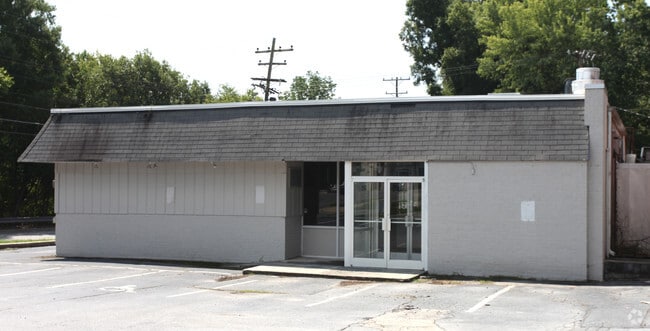
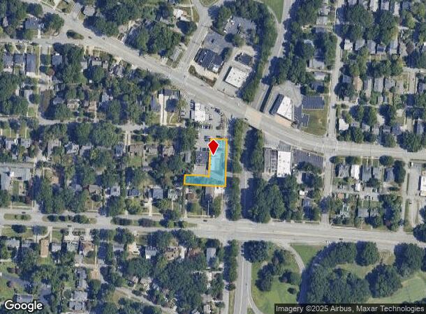
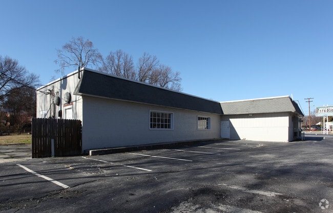
Property Record
105 Smyres Pl, Greensboro, NC 27403
Current Lease Availabilities
NEARBY LISTINGS FOR SALE OR LEASE
Property Detail
105 Smyres Pl
Greensboro-High Point, NC
Sunset Hills
0012208
SOUTHERN LIGHTS/SMYRES PL LO:20 PT 8&9 SE:1 BL:2 PL:9-85
Commercialnec
Guilford
X
North Carolina
3710785400J
20
2024
0.28 AC
2025
West Greensboro
010500
Greensboro/Winston-Salem
2,750 SF
DEMOGRAPHICS near 105 Smyres Pl
1 Mile
3 Mile
5 Mile
2024 Total Population
17,093
94,968
224,798
2029 Population
17,123
95,084
224,429
Pop Growth 2024-2029
+ 0.18%
+ 0.12%
(0.16%)
Average Age
30
36
38
2024 Total Households
5,041
35,709
91,946
HH Growth 2024-2029
+ 0.79%
+ 0.32%
(0.13%)
Median Household Inc
$61,614
$49,541
$49,565
Avg Household Size
1.90
2.20
2.20
2024 Avg HH Vehicles
2.00
2.00
2.00
Median Home Value
$284,758
$227,978
$179,280
Median Year Built
1954
1965
1978
Nearby Places
- Restaurants
- Banks
- Shops
- Fitness
- Groceries
PUBLIC TRANSPORTATION
COMMUTER RAIL
Greensboro Station (Piedmont - North Carolina by Train (NC Train))
DRIVE
WALK
Distance
Greensboro Station (Piedmont - North Carolina by Train (NC Train))
4 min
1.7 mi
AIRPORT
Piedmont Triad International
DRIVE
WALK
Distance
Piedmont Triad International
22 min
8.0 mi
Nearby Properties
Address
Land Use
TOTAL SIZE
Lot Size
Zoning
Address
Land Use
TOTAL SIZE
Lot Size
Zoning
908,421 SF
62.30 AC
PI
Address
Land Use
TOTAL SIZE
Lot Size
Zoning
1,864,781 SF
96.17 AC
PI
Address
Land Use
TOTAL SIZE
Lot Size
Zoning
671,937 SF
44.01 AC
PI
Address
Land Use
TOTAL SIZE
Lot Size
Zoning
593,135 SF
26.07 AC
PI
Address
Land Use
TOTAL SIZE
Lot Size
Zoning
646,229 SF
25.47 AC
LI
Address
Land Use
TOTAL SIZE
Lot Size
Zoning
905,672 SF
28.64 AC
PI
Address
Land Use
TOTAL SIZE
Lot Size
Zoning
733,612 SF
19.38 AC
PI
Address
Land Use
TOTAL SIZE
Lot Size
Zoning
388,224 SF
0.98 AC
CB
Address
Land Use
TOTAL SIZE
Lot Size
Zoning
356,139 SF
0.99 AC
CB
Address
Land Use
TOTAL SIZE
Lot Size
Zoning
549,907 SF
43.02 AC
C-H
Address
Land Use
TOTAL SIZE
Lot Size
Zoning
957,290 SF
18.71 AC
C-H
Address
Land Use
TOTAL SIZE
Lot Size
Zoning
2.09 AC
CB
Address
Land Use
TOTAL SIZE
Lot Size
Zoning
352,060 SF
3.67 AC
CB
Address
Land Use
TOTAL SIZE
Lot Size
Zoning
364,370 SF
1.85 AC
CB
Address
Land Use
TOTAL SIZE
Lot Size
Zoning
303,490 SF
1.29 AC
CB
Address
Land Use
TOTAL SIZE
Lot Size
Zoning
275,122 SF
0.76 AC
CB
Address
Land Use
TOTAL SIZE
Lot Size
Zoning
413,840 SF
3.68 AC
PI
Address
Land Use
TOTAL SIZE
Lot Size
Zoning
342,490 SF
17.99 AC
PI
Address
Land Use
TOTAL SIZE
Lot Size
Zoning
228,253 SF
11.21 AC
RM-18
Address
Land Use
TOTAL SIZE
Lot Size
Zoning
287,581 SF
39.35 AC
PI
Address
Land Use
TOTAL SIZE
Lot Size
Zoning
361,604 SF
16.55 AC
RM-18
Address
Land Use
TOTAL SIZE
Lot Size
Zoning
163,439 SF
4.01 AC
CB
Address
Land Use
TOTAL SIZE
Lot Size
Zoning
321,985 SF
4.80 AC
C-H
Address
Land Use
TOTAL SIZE
Lot Size
Zoning
358,324 SF
4.02 AC
PUD
Address
Land Use
TOTAL SIZE
Lot Size
Zoning
163,346 SF
0.92 AC
CB
Address
Land Use
TOTAL SIZE
Lot Size
Zoning
291,464 SF
17.51 AC
PI
Address
Land Use
TOTAL SIZE
Lot Size
Zoning
249,779 SF
2.83 AC
CB
Address
Land Use
TOTAL SIZE
Lot Size
Zoning
170,200 SF
1.05 AC
CB
Address
Land Use
TOTAL SIZE
Lot Size
Zoning
661,843 SF
46.38 AC
PI
Address
Land Use
TOTAL SIZE
Lot Size
Zoning
236,374 SF
7.69 AC
CB
The World's #1 Commercial Real Estate Marketplace
Connect with us
© 2025 CoStar Group
The information above has been obtained from sources believed reliable. While we do not doubt its accuracy we have not verified it and make no guarantee, warranty or representation about it. It is your responsibility to independently confirm its accuracy and completeness. Any projections, opinions, assumptions, or estimates used are for example only and do not represent the current or future performance of the property. The value of this transaction to you depends on tax and other factors which should be evaluated by your tax, financial, and legal advisors. You and your advisors should conduct a careful, independent investigation of the property to determine to your satisfaction the suitability of the property for your needs.