Property Record
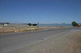
Pm141 67/68 Cal Oak, Oroville, CA 95965

Property Detail
Pm141 67/68 Cal Oak
Chico, CA
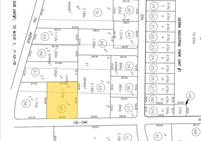
LOT 1 PM 141-67/68 CAL OAK RD
035-380-055-000
BUTTE
Industrialacreage
California
C and X Area of minimal flood hazard, usually depicted on FIRMs as above the 500-year flood level.
1
2024
1.72 AC
2025
California North Rural Area
002500
Other Market Areas
NEARBY LISTINGS FOR SALE OR LEASE
DEMOGRAPHICS near Pm141 67/68 Cal Oak
1 mile
3 mile
5 mile
2025 Total Population
2,347
30,921
39,232
2030 Population
2,355
30,821
39,061
Pop Growth 2025-2030
+ 0.34%
(0.32%)
(0.44%)
Average Age
37
37
38
2025 Total Households
917
10,833
13,914
HH Growth 2025-2030
+ 0.22%
(0.40%)
(0.52%)
Median Household Inc
$39,999
$51,905
$55,235
Avg Household Size
2.50
2.70
2.70
2025 Avg HH Vehicles
1.00
2.00
2.00
Median Home Value
$215,591
$285,466
$307,429
Median Year Built
1967
1967
1970
Nearby Places
Map Layers
Map Styles
 Street
 Aerial
Layers
 Traffic
 Biking
Places
Listings with unknown addresses are not visible on the map
- Restaurants
- Banks
- Shops
- Fitness
- Groceries
SALE & LEASE HISTORY
LISTING DATE
SALE/LEASE

Sep 24, 2016
For Sale
Nearby Properties
Address
Land Use
TOTAL SIZE
Lot Size
Zoning
Address
Land Use
TOTAL SIZE
Lot Size
Zoning
14.25 AC
C1
Address
Land Use
TOTAL SIZE
Lot Size
Zoning
17.29 AC
Address
Land Use
TOTAL SIZE
Lot Size
Zoning
182,327 SF
21.17 AC
M2
Address
Land Use
TOTAL SIZE
Lot Size
Zoning
36,746 SF
8.39 AC
Address
Land Use
TOTAL SIZE
Lot Size
Zoning
18,980 SF
7.37 AC
HI
Address
Land Use
TOTAL SIZE
Lot Size
Zoning
95,604 SF
8.90 AC
C2
Address
Land Use
TOTAL SIZE
Lot Size
Zoning
2,463 SF
6.96 AC
RP
Address
Land Use
TOTAL SIZE
Lot Size
Zoning
44,461 SF
8.32 AC
C1
Address
Land Use
TOTAL SIZE
Lot Size
Zoning
58,808 SF
4.54 AC
C1
Address
Land Use
TOTAL SIZE
Lot Size
Zoning
66,651 SF
5.08 AC
MHDR
Address
Land Use
TOTAL SIZE
Lot Size
Zoning
75,693 SF
3.15 AC
R-4
Address
Land Use
TOTAL SIZE
Lot Size
Zoning
70,306 SF
2.74 AC
R-4
Address
Land Use
TOTAL SIZE
Lot Size
Zoning
58,254 SF
3.52 AC
Address
Land Use
TOTAL SIZE
Lot Size
Zoning
9,874 SF
5 AC
RP
Address
Land Use
TOTAL SIZE
Lot Size
Zoning
102,513 SF
12.11 AC
C2
Address
Land Use
TOTAL SIZE
Lot Size
Zoning
11.54 AC
PQ
Address
Land Use
TOTAL SIZE
Lot Size
Zoning
53,941 SF
2.47 AC
C2
Address
Land Use
TOTAL SIZE
Lot Size
Zoning
44,186 SF
4.28 AC
Address
Land Use
TOTAL SIZE
Lot Size
Zoning
5,995 SF
4.75 AC
C2
Address
Land Use
TOTAL SIZE
Lot Size
Zoning
43,536 SF
2.89 AC
Address
Land Use
TOTAL SIZE
Lot Size
Zoning
48,151 SF
1.85 AC
C2
Address
Land Use
TOTAL SIZE
Lot Size
Zoning
52,294 SF
2.12 AC
R3
Address
Land Use
TOTAL SIZE
Lot Size
Zoning
84,500 SF
6.48 AC
C1
Address
Land Use
TOTAL SIZE
Lot Size
Zoning
64,616 SF
5.80 AC
Address
Land Use
TOTAL SIZE
Lot Size
Zoning
37,374 SF
2.36 AC
Address
Land Use
TOTAL SIZE
Lot Size
Zoning
65,172 SF
4.45 AC
PD
Address
Land Use
TOTAL SIZE
Lot Size
Zoning
150,712 SF
7.78 AC
RP
Address
Land Use
TOTAL SIZE
Lot Size
Zoning
126,045 SF
8.87 AC
M2
Address
Land Use
TOTAL SIZE
Lot Size
Zoning
51,999 SF
3.69 AC
CLM
Address
Land Use
TOTAL SIZE
Lot Size
Zoning
36.95 AC
MU-1
The World's #1 Commercial Real Estate Marketplace
Connect with us
© 2026 CoStar Group
The information above has been obtained from sources believed reliable. While we do not doubt its accuracy we have not verified it and make no guarantee, warranty or representation about it. It is your responsibility to independently confirm its accuracy and completeness. Any projections, opinions, assumptions, or estimates used are for example only and do not represent the current or future performance of the property. The value of this transaction to you depends on tax and other factors which should be evaluated by your tax, financial, and legal advisors. You and your advisors should conduct a careful, independent investigation of the property to determine to your satisfaction the suitability of the property for your needs.