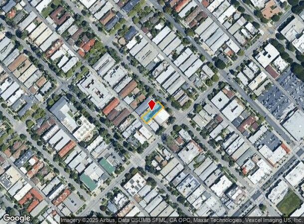
Property Record
1050 12Th St, Santa Monica, CA 90403
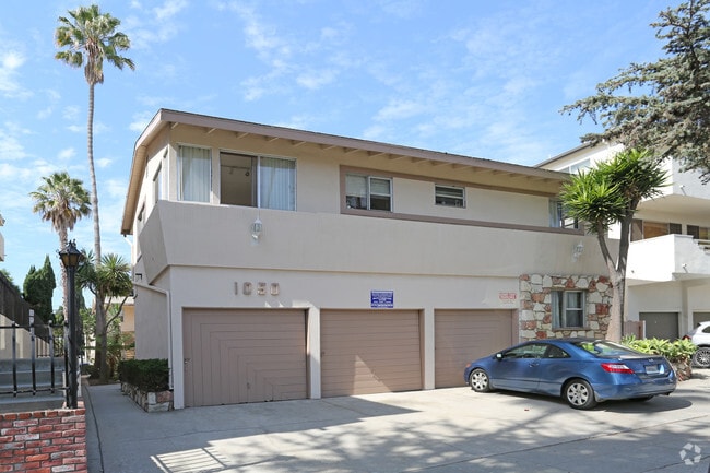
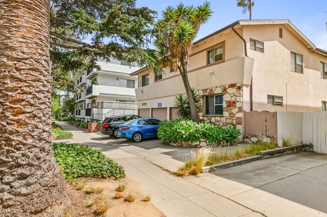

This Property Is For Sale
NEARBY LISTINGS FOR SALE OR LEASE
Property Detail
1050 12Th St
Los Angeles-Long Beach-Glendale, CA
Santa Monica
4281-021-010
SANTA MONICA LOT J BLK 65
Multifamilydwelling
Los Angeles
X
California
06037C1588G
j
2024
0.17 AC
2025
Wilshire Montana
701501
Los Angeles
7,068 SF
DEMOGRAPHICS near 1050 12Th St
1 Mile
3 Mile
5 Mile
2024 Total Population
44,213
193,397
432,693
2029 Population
43,668
189,759
425,373
Pop Growth 2024-2029
(1.23%)
(1.88%)
(1.69%)
Average Age
44
42
41
2024 Total Households
23,680
95,111
197,316
HH Growth 2024-2029
(1.28%)
(2.01%)
(1.85%)
Median Household Inc
$116,473
$112,109
$108,206
Avg Household Size
1.80
2.00
2.00
2024 Avg HH Vehicles
1.00
1.00
1.00
Median Home Value
$1,113,558
$1,112,325
$1,110,860
Median Year Built
1970
1968
1971
Nearby Places
- Restaurants
- Banks
- Shops
- Fitness
- Groceries
PUBLIC TRANSPORTATION
TRANSIT/SUBWAY
17 St/ SMC (Expo Line - Los Angeles County Metropolitan Transportation Authority (Metro))
DRIVE
WALK
Distance
17 St/ SMC (Expo Line - Los Angeles County Metropolitan Transportation Authority (Metro))
3 min
19 min
1.0 mi
AIRPORT
Los Angeles International
DRIVE
WALK
Distance
Los Angeles International
19 min
9.4 mi
Bob Hope
DRIVE
WALK
Distance
Bob Hope
36 min
21.1 mi
Long Beach (Daugherty Field)
DRIVE
WALK
Distance
Long Beach (Daugherty Field)
40 min
29.6 mi
Freight Ports
Port of Long Beach
DRIVE
WALK
Distance
Port of Long Beach
43 min
31.6 mi
Nearby Properties
Address
Land Use
TOTAL SIZE
Lot Size
Zoning
Address
Land Use
TOTAL SIZE
Lot Size
Zoning
486,993 SF
8.31 AC
SMCP3-CP5*
Address
Land Use
TOTAL SIZE
Lot Size
Zoning
318,556 SF
3.19 AC
SMC5*
Address
Land Use
TOTAL SIZE
Lot Size
Zoning
500,629 SF
1.60 AC
LAC4
Address
Land Use
TOTAL SIZE
Lot Size
Zoning
197,520 SF
0.81 AC
SMRVC*
Address
Land Use
TOTAL SIZE
Lot Size
Zoning
301,579 SF
2.69 AC
SMRVC*
Address
Land Use
TOTAL SIZE
Lot Size
Zoning
858,380 SF
7.23 AC
SMC5*
Address
Land Use
TOTAL SIZE
Lot Size
Zoning
35,635 SF
2.81 AC
LAC2
Address
Land Use
TOTAL SIZE
Lot Size
Zoning
483,875 SF
7.31 AC
SMC5*
Address
Land Use
TOTAL SIZE
Lot Size
Zoning
475,736 SF
4.94 AC
SMC3C*
Address
Land Use
TOTAL SIZE
Lot Size
Zoning
424,403 SF
1.76 AC
SMLMSD*
Address
Land Use
TOTAL SIZE
Lot Size
Zoning
208,783 SF
2.94 AC
SMLMSD*
Address
Land Use
TOTAL SIZE
Lot Size
Zoning
65,958 SF
6.79 AC
MOM*
Address
Land Use
TOTAL SIZE
Lot Size
Zoning
178,691 SF
3.42 AC
SMRMH*
Address
Land Use
TOTAL SIZE
Lot Size
Zoning
500,824 SF
3.59 AC
LAC2
Address
Land Use
TOTAL SIZE
Lot Size
Zoning
322,769 SF
3.61 AC
SMC5*
Address
Land Use
TOTAL SIZE
Lot Size
Zoning
172,273 SF
1.21 AC
SMC3
Address
Land Use
TOTAL SIZE
Lot Size
Zoning
102,157 SF
0.71 AC
SMRVC*
Address
Land Use
TOTAL SIZE
Lot Size
Zoning
350,132 SF
3.91 AC
SMC5*
Address
Land Use
TOTAL SIZE
Lot Size
Zoning
73,316 SF
2.07 AC
SMLMSD*
Address
Land Use
TOTAL SIZE
Lot Size
Zoning
355,770 SF
1.12 AC
LAC2
Address
Land Use
TOTAL SIZE
Lot Size
Zoning
126,282 SF
0.86 AC
SMC3-R3A*
Address
Land Use
TOTAL SIZE
Lot Size
Zoning
293,240 SF
3.35 AC
SMC5*
Address
Land Use
TOTAL SIZE
Lot Size
Zoning
321,111 SF
3.31 AC
SMCC*
Address
Land Use
TOTAL SIZE
Lot Size
Zoning
89,748 SF
2.13 AC
Address
Land Use
TOTAL SIZE
Lot Size
Zoning
419,445 SF
2.81 AC
LAC2
Address
Land Use
TOTAL SIZE
Lot Size
Zoning
532,416 SF
4.96 AC
SMOP4*
Address
Land Use
TOTAL SIZE
Lot Size
Zoning
417,650 SF
7.43 AC
LAM2
Address
Land Use
TOTAL SIZE
Lot Size
Zoning
189,347 SF
4.34 AC
SMC5*
Address
Land Use
TOTAL SIZE
Lot Size
Zoning
418,909 SF
1.93 AC
LAM2
Address
Land Use
TOTAL SIZE
Lot Size
Zoning
285,379 SF
0.56 AC
SMRVC*
The World's #1 Commercial Real Estate Marketplace
Connect with us
© 2025 CoStar Group
The information above has been obtained from sources believed reliable. While we do not doubt its accuracy we have not verified it and make no guarantee, warranty or representation about it. It is your responsibility to independently confirm its accuracy and completeness. Any projections, opinions, assumptions, or estimates used are for example only and do not represent the current or future performance of the property. The value of this transaction to you depends on tax and other factors which should be evaluated by your tax, financial, and legal advisors. You and your advisors should conduct a careful, independent investigation of the property to determine to your satisfaction the suitability of the property for your needs.