Property Record
1050 Branger Dr, Mineral Point, WI 53565

NEARBY LISTINGS FOR SALE OR LEASE
-
-
View all Mineral Point listings for sale on LoopNet.com
Property Detail
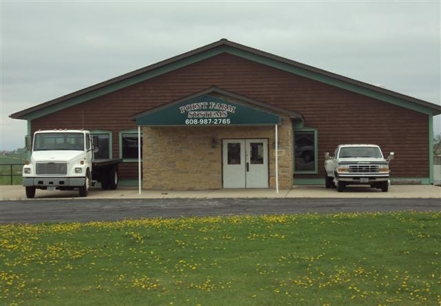
1050 Branger Dr
Madison, WI
Str: Ne4sw4s29t5nr3e
251-1113.002
LOT 1 CSM 610 REC IN V 4 CS P 58 BEING PT OF LOT 2 CSM 499 LOCATED IN THE NE1/4 OF SW1/4
Commercialnec
Iowa
X
Wisconsin
55049C0370D
1-2
2024
2.67 AC
2024
Iowa County
950300
Milwaukee/Madison
DEMOGRAPHICS near 1050 Branger Dr
1 Mile
3 Mile
5 Mile
2024 Total Population
372
3,314
3,961
2029 Population
376
3,372
4,025
Pop Growth 2024-2029
+ 1.08%
+ 1.75%
+ 1.62%
Average Age
44
43
43
2024 Total Households
160
1,456
1,736
HH Growth 2024-2029
+ 1.25%
+ 1.72%
+ 1.56%
Median Household Inc
$64,091
$67,317
$66,827
Avg Household Size
2.30
2.20
2.20
2024 Avg HH Vehicles
2.00
2.00
2.00
Median Home Value
$246,341
$222,956
$219,200
Median Year Built
1974
1956
1958
Nearby Places
Map Layers
Map Styles
 Street
 Aerial
- Restaurants
- Banks
- Shops
- Fitness
- Groceries
Nearby Properties
Address
Land Use
TOTAL SIZE
Lot Size
Zoning
Address
Land Use
TOTAL SIZE
Lot Size
Zoning
9.36 AC
Address
Land Use
TOTAL SIZE
Lot Size
Zoning
2.44 AC
Address
Land Use
TOTAL SIZE
Lot Size
Zoning
0.60 AC
Address
Land Use
TOTAL SIZE
Lot Size
Zoning
15.95 AC
Address
Land Use
TOTAL SIZE
Lot Size
Zoning
Address
Land Use
TOTAL SIZE
Lot Size
Zoning
1.12 AC
Address
Land Use
TOTAL SIZE
Lot Size
Zoning
1.01 AC
Address
Land Use
TOTAL SIZE
Lot Size
Zoning
1.65 AC
Address
Land Use
TOTAL SIZE
Lot Size
Zoning
Address
Land Use
TOTAL SIZE
Lot Size
Zoning
Address
Land Use
TOTAL SIZE
Lot Size
Zoning
4.60 AC
Address
Land Use
TOTAL SIZE
Lot Size
Zoning
1.57 AC
Address
Land Use
TOTAL SIZE
Lot Size
Zoning
Address
Land Use
TOTAL SIZE
Lot Size
Zoning
Address
Land Use
TOTAL SIZE
Lot Size
Zoning
Address
Land Use
TOTAL SIZE
Lot Size
Zoning
Address
Land Use
TOTAL SIZE
Lot Size
Zoning
Address
Land Use
TOTAL SIZE
Lot Size
Zoning
4.65 AC
Address
Land Use
TOTAL SIZE
Lot Size
Zoning
Address
Land Use
TOTAL SIZE
Lot Size
Zoning
3.77 AC
Address
Land Use
TOTAL SIZE
Lot Size
Zoning
Address
Land Use
TOTAL SIZE
Lot Size
Zoning
Address
Land Use
TOTAL SIZE
Lot Size
Zoning
Address
Land Use
TOTAL SIZE
Lot Size
Zoning
5.08 AC
Address
Land Use
TOTAL SIZE
Lot Size
Zoning
Address
Land Use
TOTAL SIZE
Lot Size
Zoning
Address
Land Use
TOTAL SIZE
Lot Size
Zoning
0.97 AC
Address
Land Use
TOTAL SIZE
Lot Size
Zoning
The World's #1 Commercial Real Estate Marketplace
Connect with us
© 2025 CoStar Group
The information above has been obtained from sources believed reliable. While we do not doubt its accuracy we have not verified it and make no guarantee, warranty or representation about it. It is your responsibility to independently confirm its accuracy and completeness. Any projections, opinions, assumptions, or estimates used are for example only and do not represent the current or future performance of the property. The value of this transaction to you depends on tax and other factors which should be evaluated by your tax, financial, and legal advisors. You and your advisors should conduct a careful, independent investigation of the property to determine to your satisfaction the suitability of the property for your needs.