Property Record
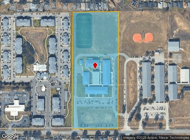
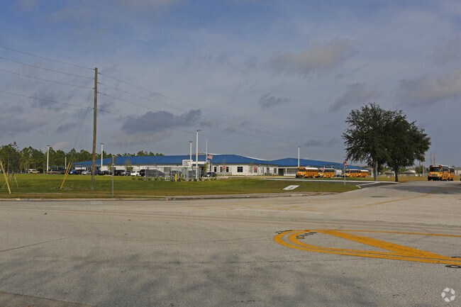
1050 Dunson Rd, Davenport, FL 33896

NEARBY LISTINGS FOR SALE OR LEASE
Property Detail
1050 Dunson Rd
27-26-06-000000-042030
Alameda Heights
Privateschool
COMM SE COR OF SE1/4 OF SW1/4 OF SEC N0-13-02W ALONG E LINE OF SE1/4 OF SW1/4 40 FT TO POB N0-13- 02W ALONG SAID E LINE 1280.81 FT TO S LINE OF HAMLET AT WEST HAVEN REC IN PB 124 PG 7 S89-06-08W ALONG S LINE OF SAID SUB 510.32 FT S0-13-02E 1280.1 FT
X
Polk
12105C0225G
Florida
0
15.15 AC
2025
Polk County
012405
Tampa/St Petersburg
79,031 SF
Lakeland-Winter Haven, FL
DEMOGRAPHICS near 1050 Dunson Rd
1 Mile
3 Mile
5 Mile
2024 Total Population
5,783
41,528
85,799
2029 Population
7,332
52,165
107,474
Pop Growth 2024-2029
+ 26.79%
+ 25.61%
+ 25.26%
Average Age
40
39
39
2024 Total Households
2,163
15,538
31,197
HH Growth 2024-2029
+ 26.95%
+ 25.69%
+ 25.34%
Median Household Inc
$72,954
$70,959
$67,444
Avg Household Size
2.60
2.60
2.70
2024 Avg HH Vehicles
2.00
2.00
2.00
Median Home Value
$266,690
$260,219
$262,314
Median Year Built
2009
2008
2007
Nearby Places
Map Layers
Map Styles
 Street
 Aerial
- Restaurants
- Banks
- Shops
- Fitness
- Groceries
PUBLIC TRANSPORTATION
AIRPORT
Orlando International
DRIVE
WALK
Distance
Orlando International
44 min
30.5 mi
Freight Ports
Port of Tampa Bay
DRIVE
WALK
Distance
Port of Tampa Bay
72 min
58.1 mi
Nearby Properties
Address
Land Use
TOTAL SIZE
Lot Size
Zoning
Address
Land Use
TOTAL SIZE
Lot Size
Zoning
736,399 SF
23.59 AC
OPD
Address
Land Use
TOTAL SIZE
Lot Size
Zoning
1,125,150 SF
51.12 AC
RC
Address
Land Use
TOTAL SIZE
Lot Size
Zoning
969,150 SF
91.98 AC
RC
Address
Land Use
TOTAL SIZE
Lot Size
Zoning
295,034 SF
14.25 AC
Address
Land Use
TOTAL SIZE
Lot Size
Zoning
422,457 SF
17.46 AC
Address
Land Use
TOTAL SIZE
Lot Size
Zoning
336,380 SF
19.05 AC
Address
Land Use
TOTAL SIZE
Lot Size
Zoning
380,530 SF
18.92 AC
RC
Address
Land Use
TOTAL SIZE
Lot Size
Zoning
436,302 SF
27.87 AC
Address
Land Use
TOTAL SIZE
Lot Size
Zoning
480,104 SF
12.37 AC
Address
Land Use
TOTAL SIZE
Lot Size
Zoning
403,448 SF
14.96 AC
Address
Land Use
TOTAL SIZE
Lot Size
Zoning
322,095 SF
16.88 AC
Address
Land Use
TOTAL SIZE
Lot Size
Zoning
301,623 SF
20.06 AC
Address
Land Use
TOTAL SIZE
Lot Size
Zoning
412,886 SF
10.72 AC
Address
Land Use
TOTAL SIZE
Lot Size
Zoning
372,655 SF
17.06 AC
C5
Address
Land Use
TOTAL SIZE
Lot Size
Zoning
354,600 SF
14.93 AC
Address
Land Use
TOTAL SIZE
Lot Size
Zoning
308,973 SF
18.38 AC
Address
Land Use
TOTAL SIZE
Lot Size
Zoning
479,776 SF
20.90 AC
Address
Land Use
TOTAL SIZE
Lot Size
Zoning
360,270 SF
16.97 AC
OPD
Address
Land Use
TOTAL SIZE
Lot Size
Zoning
328,817 SF
12.62 AC
Address
Land Use
TOTAL SIZE
Lot Size
Zoning
491,027 SF
18.81 AC
RC
Address
Land Use
TOTAL SIZE
Lot Size
Zoning
601,750 SF
32.69 AC
Address
Land Use
TOTAL SIZE
Lot Size
Zoning
256,589 SF
15.37 AC
OPD
Address
Land Use
TOTAL SIZE
Lot Size
Zoning
450,000 SF
34.23 AC
Address
Land Use
TOTAL SIZE
Lot Size
Zoning
236,745 SF
26.56 AC
Address
Land Use
TOTAL SIZE
Lot Size
Zoning
164,106 SF
7.13 AC
Address
Land Use
TOTAL SIZE
Lot Size
Zoning
406,208 SF
59.48 AC
Address
Land Use
TOTAL SIZE
Lot Size
Zoning
404,725 SF
26.87 AC
Address
Land Use
TOTAL SIZE
Lot Size
Zoning
192,257 SF
5.79 AC
Address
Land Use
TOTAL SIZE
Lot Size
Zoning
319,770 SF
40.72 AC
XX
Address
Land Use
TOTAL SIZE
Lot Size
Zoning
447,000 SF
23.26 AC
The World's #1 Commercial Real Estate Marketplace
Connect with us
© 2026 CoStar Group
The information above has been obtained from sources believed reliable. While we do not doubt its accuracy we have not verified it and make no guarantee, warranty or representation about it. It is your responsibility to independently confirm its accuracy and completeness. Any projections, opinions, assumptions, or estimates used are for example only and do not represent the current or future performance of the property. The value of this transaction to you depends on tax and other factors which should be evaluated by your tax, financial, and legal advisors. You and your advisors should conduct a careful, independent investigation of the property to determine to your satisfaction the suitability of the property for your needs.