Property Record
1050 E Main St, Madison, WI 53703

NEARBY LISTINGS FOR SALE OR LEASE
-
-
View all Madison listings for sale on LoopNet.com
Property Detail
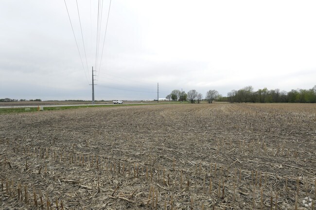
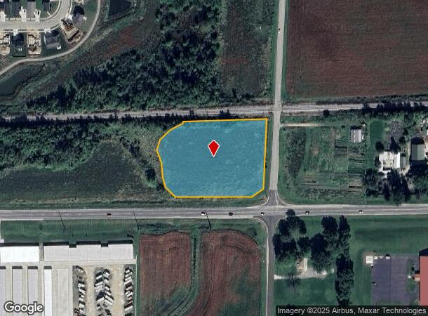
1050 E Main St
Madison, WI
LOT 3 CSM 16354 CS121/295-304 09/26/2023 F/K/A SEC 4-8-11 PRT NE1/4SE1/4, PRT SE 1/4SE1/4 & PRT SW1/4SE1/4 DESCR AS COM AT E1/4 COR OF SEC 4 TH S02DEG00'27W ALG E LN OF SE1/4 OF SD SEC 4 2253.85 FT TO S R/W LN OF CANADIAN PACIFIC RR & POB T H CONT S0
0811-044-9775-2
Dane
Commercialnec
Wisconsin
X
3
55025C0287H
2.89 AC
2024
Outlying Dane East
2024
Milwaukee/Madison
001901
DEMOGRAPHICS near 1050 E Main St
1 mile
3 mile
5 mile
2024 Total Population
5,545
25,558
46,419
2029 Population
5,710
26,497
48,191
Pop Growth 2024-2029
+ 2.98%
+ 3.67%
+ 3.82%
Average Age
38
38
38
2024 Total Households
2,204
10,142
18,315
HH Growth 2024-2029
+ 3.04%
+ 3.81%
+ 4.00%
Median Household Inc
$102,639
$79,259
$89,551
Avg Household Size
2.50
2.40
2.50
2024 Avg HH Vehicles
2.00
2.00
2.00
Median Home Value
$307,836
$296,306
$323,377
Median Year Built
1991
1989
1996
Nearby Places
Map Layers
Map Styles
 Street
 Aerial
Transit
 Traffic
 Biking
Places
Listings with unknown addresses are not visible on the map
- Restaurants
- Banks
- Shops
- Fitness
- Groceries
PUBLIC TRANSPORTATION
AIRPORT
Dane County Regional/Truax Field
Drive
Walk
Distance
Dane County Regional/Truax Field
20 min
11.7 mi
Freight Ports
Port Milwaukee
Drive
Walk
Distance
Port Milwaukee
89 min
75.2 mi
Nearby Properties
Address
Land Use
TOTAL SIZE
Lot Size
Zoning
Address
Land Use
TOTAL SIZE
Lot Size
Zoning
4.64 AC
Address
Land Use
TOTAL SIZE
Lot Size
Zoning
31,986 SF
5 AC
PD
Address
Land Use
TOTAL SIZE
Lot Size
Zoning
147,310 SF
14.68 AC
SC
Address
Land Use
TOTAL SIZE
Lot Size
Zoning
12.16 AC
Address
Land Use
TOTAL SIZE
Lot Size
Zoning
430,172 SF
18.33 AC
SI
Address
Land Use
TOTAL SIZE
Lot Size
Zoning
16,464 SF
7.37 AC
UR12
Address
Land Use
TOTAL SIZE
Lot Size
Zoning
155,550 SF
21.13 AC
SI
Address
Land Use
TOTAL SIZE
Lot Size
Zoning
24.49 AC
Address
Land Use
TOTAL SIZE
Lot Size
Zoning
15.24 AC
ABA
Address
Land Use
TOTAL SIZE
Lot Size
Zoning
15,288 SF
14.55 AC
UR12
Address
Land Use
TOTAL SIZE
Lot Size
Zoning
39,676 SF
2.57 AC
UC
Address
Land Use
TOTAL SIZE
Lot Size
Zoning
1.76 AC
Address
Land Use
TOTAL SIZE
Lot Size
Zoning
12.24 AC
Address
Land Use
TOTAL SIZE
Lot Size
Zoning
61,029 SF
6 AC
Address
Land Use
TOTAL SIZE
Lot Size
Zoning
21.09 AC
SI
Address
Land Use
TOTAL SIZE
Lot Size
Zoning
46,035 SF
1.84 AC
PD
Address
Land Use
TOTAL SIZE
Lot Size
Zoning
26,675 SF
5.02 AC
UR12
Address
Land Use
TOTAL SIZE
Lot Size
Zoning
Address
Land Use
TOTAL SIZE
Lot Size
Zoning
12.21 AC
Address
Land Use
TOTAL SIZE
Lot Size
Zoning
19,200 SF
9.02 AC
SC
Address
Land Use
TOTAL SIZE
Lot Size
Zoning
8.19 AC
SI
Address
Land Use
TOTAL SIZE
Lot Size
Zoning
Address
Land Use
TOTAL SIZE
Lot Size
Zoning
3,600 SF
7.75 AC
UI
Address
Land Use
TOTAL SIZE
Lot Size
Zoning
40,122 SF
5.28 AC
SO
Address
Land Use
TOTAL SIZE
Lot Size
Zoning
13.09 AC
SI
Address
Land Use
TOTAL SIZE
Lot Size
Zoning
7,888 SF
8.77 AC
UR12
Address
Land Use
TOTAL SIZE
Lot Size
Zoning
30,528 SF
1.46 AC
PD
Address
Land Use
TOTAL SIZE
Lot Size
Zoning
1.52 AC
Address
Land Use
TOTAL SIZE
Lot Size
Zoning
79,087 SF
4.03 AC
SI
Address
Land Use
TOTAL SIZE
Lot Size
Zoning
The World's #1 Commercial Real Estate Marketplace
Connect with us
© 2026 CoStar Group
The information above has been obtained from sources believed reliable. While we do not doubt its accuracy we have not verified it and make no guarantee, warranty or representation about it. It is your responsibility to independently confirm its accuracy and completeness. Any projections, opinions, assumptions, or estimates used are for example only and do not represent the current or future performance of the property. The value of this transaction to you depends on tax and other factors which should be evaluated by your tax, financial, and legal advisors. You and your advisors should conduct a careful, independent investigation of the property to determine to your satisfaction the suitability of the property for your needs.