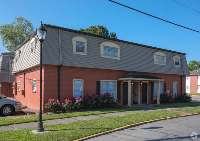
Property Record
1050 Manhattan Blvd, Harvey, LA 70058
NEARBY LISTINGS FOR SALE OR LEASE
Property Detail
1050 Manhattan Blvd
New Orleans-Metairie, LA
Manhattan Gdn
0300010319
PARCEL 2 MANHATTAN GARDENS
Realpropertynec
Jefferson
X
Louisiana
22051C0215F
0.95 AC
2024
Westbank
2024
New Orleans/Metairie/Kenner
026100
DEMOGRAPHICS near 1050 Manhattan Blvd
1 Mile
3 Mile
5 Mile
2024 Total Population
14,187
123,779
314,615
2029 Population
13,697
119,328
303,546
Pop Growth 2024-2029
(3.45%)
(3.60%)
(3.52%)
Average Age
38
40
40
2024 Total Households
5,620
52,338
132,560
HH Growth 2024-2029
(3.61%)
(3.66%)
(3.43%)
Median Household Inc
$33,488
$53,409
$54,463
Avg Household Size
2.40
2.30
2.20
2024 Avg HH Vehicles
1.00
1.00
1.00
Median Home Value
$158,648
$218,758
$240,568
Median Year Built
1968
1969
1965
Nearby Places
Map Layers
Map Styles
 Street
 Aerial
- Restaurants
- Banks
- Shops
- Fitness
- Groceries
PUBLIC TRANSPORTATION
COMMUTER RAIL
New Orleans Union Passenger Terminal (City of New Orleans - Amtrak, Crescent - Amtrak, Sunset Limited - Amtrak)
DRIVE
WALK
Distance
New Orleans Union Passenger Terminal (City of New Orleans - Amtrak, Crescent - Amtrak, Sunset Limited - Amtrak)
11 min
6.7 mi
AIRPORT
Louis Armstrong New Orleans International
DRIVE
WALK
Distance
Louis Armstrong New Orleans International
30 min
21.0 mi
Freight Ports
Port of New Orleans
DRIVE
WALK
Distance
Port of New Orleans
16 min
7.4 mi
Nearby Properties
Address
Land Use
TOTAL SIZE
Lot Size
Zoning
Address
Land Use
TOTAL SIZE
Lot Size
Zoning
3.66 AC
MC
Address
Land Use
TOTAL SIZE
Lot Size
Zoning
0.12 AC
Address
Land Use
TOTAL SIZE
Lot Size
Zoning
Address
Land Use
TOTAL SIZE
Lot Size
Zoning
512,729 SF
6.60 AC
Address
Land Use
TOTAL SIZE
Lot Size
Zoning
0.14 AC
Address
Land Use
TOTAL SIZE
Lot Size
Zoning
4.12 AC
Address
Land Use
TOTAL SIZE
Lot Size
Zoning
25.26 AC
Address
Land Use
TOTAL SIZE
Lot Size
Zoning
151,320 SF
27.55 AC
Address
Land Use
TOTAL SIZE
Lot Size
Zoning
23.90 AC
Address
Land Use
TOTAL SIZE
Lot Size
Zoning
188,935 SF
1.12 AC
CBD-6
Address
Land Use
TOTAL SIZE
Lot Size
Zoning
0.17 AC
Address
Land Use
TOTAL SIZE
Lot Size
Zoning
3.46 AC
HU-RD2
Address
Land Use
TOTAL SIZE
Lot Size
Zoning
14.40 AC
Address
Land Use
TOTAL SIZE
Lot Size
Zoning
3.55 AC
Address
Land Use
TOTAL SIZE
Lot Size
Zoning
12.79 AC
Address
Land Use
TOTAL SIZE
Lot Size
Zoning
14.69 AC
Address
Land Use
TOTAL SIZE
Lot Size
Zoning
495,542 SF
6.67 AC
HU-RM2
Address
Land Use
TOTAL SIZE
Lot Size
Zoning
Address
Land Use
TOTAL SIZE
Lot Size
Zoning
0.16 AC
Address
Land Use
TOTAL SIZE
Lot Size
Zoning
0.19 AC
Address
Land Use
TOTAL SIZE
Lot Size
Zoning
21.96 AC
MUCD
Address
Land Use
TOTAL SIZE
Lot Size
Zoning
10.14 AC
Address
Land Use
TOTAL SIZE
Lot Size
Zoning
Address
Land Use
TOTAL SIZE
Lot Size
Zoning
0.78 AC
Address
Land Use
TOTAL SIZE
Lot Size
Zoning
0.14 AC
Address
Land Use
TOTAL SIZE
Lot Size
Zoning
416,173 SF
6.34 AC
HU-RM2
Address
Land Use
TOTAL SIZE
Lot Size
Zoning
2.84 AC
Address
Land Use
TOTAL SIZE
Lot Size
Zoning
20.52 AC
MUCD
Address
Land Use
TOTAL SIZE
Lot Size
Zoning
53,036 SF
2.81 AC
MU-2
Address
Land Use
TOTAL SIZE
Lot Size
Zoning
The World's #1 Commercial Real Estate Marketplace
Connect with us
© 2025 CoStar Group
The information above has been obtained from sources believed reliable. While we do not doubt its accuracy we have not verified it and make no guarantee, warranty or representation about it. It is your responsibility to independently confirm its accuracy and completeness. Any projections, opinions, assumptions, or estimates used are for example only and do not represent the current or future performance of the property. The value of this transaction to you depends on tax and other factors which should be evaluated by your tax, financial, and legal advisors. You and your advisors should conduct a careful, independent investigation of the property to determine to your satisfaction the suitability of the property for your needs.