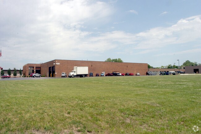
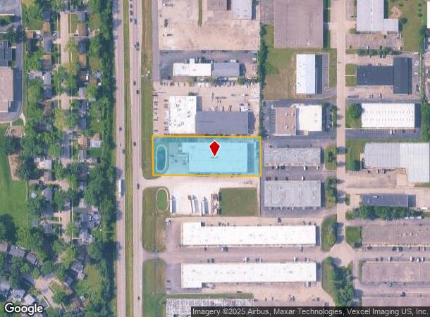
Property Record
1050 N Rand Rd, Wauconda, IL 60084
NEARBY LISTINGS FOR SALE OR LEASE
Property Detail
1050 N Rand Rd
Chicago-Naperville-Elgin, IL-IN-WI
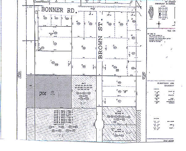
Specialty Pipe Subdivision
09-23-303-014
SPECIALTY PIPE SUBDIVISION; LOT 1
Industrialgeneral
Lake
X
Illinois
17097C0119K
1
2023
1.62 AC
2024
South Lake County
864207
Chicago
31,200 SF
DEMOGRAPHICS near 1050 N Rand Rd
1 Mile
3 Mile
5 Mile
2024 Total Population
3,586
26,594
65,444
2029 Population
3,527
26,222
64,854
Pop Growth 2024-2029
(1.65%)
(1.40%)
(0.90%)
Average Age
42
40
41
2024 Total Households
1,398
9,921
24,295
HH Growth 2024-2029
(1.72%)
(1.44%)
(0.93%)
Median Household Inc
$83,399
$95,656
$102,395
Avg Household Size
2.50
2.60
2.70
2024 Avg HH Vehicles
2.00
2.00
2.00
Median Home Value
$224,593
$271,370
$291,365
Median Year Built
1976
1987
1991
Nearby Places
Map Layers
Map Styles
 Street
 Aerial
- Restaurants
- Banks
- Shops
- Fitness
- Groceries
PUBLIC TRANSPORTATION
COMMUTER RAIL
Round Lake Station (Milwaukee District North Line - Northeast Illinois Regional Commuter Railroad (Metra))
DRIVE
WALK
Distance
Round Lake Station (Milwaukee District North Line - Northeast Illinois Regional Commuter Railroad (Metra))
13 min
8.3 mi
Long Lake Station (Milwaukee District North Line - Northeast Illinois Regional Commuter Railroad (Metra))
DRIVE
WALK
Distance
Long Lake Station (Milwaukee District North Line - Northeast Illinois Regional Commuter Railroad (Metra))
12 min
8.9 mi
AIRPORT
Chicago O'Hare International
DRIVE
WALK
Distance
Chicago O'Hare International
65 min
34.1 mi
Nearby Properties
Address
Land Use
TOTAL SIZE
Lot Size
Zoning
Address
Land Use
TOTAL SIZE
Lot Size
Zoning
220,060 SF
11.75 AC
Address
Land Use
TOTAL SIZE
Lot Size
Zoning
68,132 SF
1.96 AC
Address
Land Use
TOTAL SIZE
Lot Size
Zoning
32.23 AC
Address
Land Use
TOTAL SIZE
Lot Size
Zoning
212,880 SF
20.06 AC
Address
Land Use
TOTAL SIZE
Lot Size
Zoning
114,186 SF
17.14 AC
Address
Land Use
TOTAL SIZE
Lot Size
Zoning
258,252 SF
1.97 AC
Address
Land Use
TOTAL SIZE
Lot Size
Zoning
118,869 SF
5.88 AC
Address
Land Use
TOTAL SIZE
Lot Size
Zoning
521,479 SF
6.20 AC
Address
Land Use
TOTAL SIZE
Lot Size
Zoning
1,525,750 SF
7.55 AC
Address
Land Use
TOTAL SIZE
Lot Size
Zoning
326,933 SF
23.75 AC
Address
Land Use
TOTAL SIZE
Lot Size
Zoning
34,600 SF
2.91 AC
Address
Land Use
TOTAL SIZE
Lot Size
Zoning
54,572 SF
4.97 AC
Address
Land Use
TOTAL SIZE
Lot Size
Zoning
142,560 SF
8.02 AC
Address
Land Use
TOTAL SIZE
Lot Size
Zoning
100,000 SF
5.13 AC
Address
Land Use
TOTAL SIZE
Lot Size
Zoning
77,881 SF
4.60 AC
Address
Land Use
TOTAL SIZE
Lot Size
Zoning
10.55 AC
Address
Land Use
TOTAL SIZE
Lot Size
Zoning
18,873 SF
159.95 AC
Address
Land Use
TOTAL SIZE
Lot Size
Zoning
123,948 SF
4 AC
Address
Land Use
TOTAL SIZE
Lot Size
Zoning
56,042 SF
1.15 AC
Address
Land Use
TOTAL SIZE
Lot Size
Zoning
4,256 SF
6.62 AC
Address
Land Use
TOTAL SIZE
Lot Size
Zoning
99,256 SF
2 AC
Address
Land Use
TOTAL SIZE
Lot Size
Zoning
56,566 SF
1.86 AC
Address
Land Use
TOTAL SIZE
Lot Size
Zoning
44,952 SF
3.26 AC
Address
Land Use
TOTAL SIZE
Lot Size
Zoning
163,800 SF
5 AC
Address
Land Use
TOTAL SIZE
Lot Size
Zoning
71,007 SF
7.02 AC
Address
Land Use
TOTAL SIZE
Lot Size
Zoning
70,062 SF
12.03 AC
Address
Land Use
TOTAL SIZE
Lot Size
Zoning
129,600 SF
17.05 AC
Address
Land Use
TOTAL SIZE
Lot Size
Zoning
13,833 SF
1.54 AC
Address
Land Use
TOTAL SIZE
Lot Size
Zoning
17,939 SF
16.60 AC
Address
Land Use
TOTAL SIZE
Lot Size
Zoning
40,108 SF
3.46 AC
The World's #1 Commercial Real Estate Marketplace
Connect with us
© 2025 CoStar Group
The information above has been obtained from sources believed reliable. While we do not doubt its accuracy we have not verified it and make no guarantee, warranty or representation about it. It is your responsibility to independently confirm its accuracy and completeness. Any projections, opinions, assumptions, or estimates used are for example only and do not represent the current or future performance of the property. The value of this transaction to you depends on tax and other factors which should be evaluated by your tax, financial, and legal advisors. You and your advisors should conduct a careful, independent investigation of the property to determine to your satisfaction the suitability of the property for your needs.