Property Record
1024 Nw 38Th St, Lawton, OK 73505
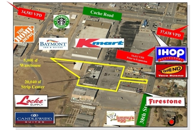

NEARBY LISTINGS FOR SALE OR LEASE
Property Detail
1024 Nw 38Th St
Lawton, OK
2N-12W City Tracts
0026894
27-2N-12W C T COM AT NE/C NE/4; (S0*E) ALG SEC LNE 1417.8'; (S89*58'W) 548', (N0*02'W) 315', (N39*14'W) 318.02', (N0*02'W) 85
Commercialacreage
Comanche
X
Oklahoma
40031C0427E
1
2024
0.52 AC
2025
Oklahoma West Area
000300
Other Market Areas
DEMOGRAPHICS near 1024 Nw 38Th St
1 Mile
3 Mile
5 Mile
2024 Total Population
10,018
66,200
82,688
2029 Population
10,356
68,632
85,575
Pop Growth 2024-2029
+ 3.37%
+ 3.67%
+ 3.49%
Average Age
38
37
36
2024 Total Households
4,242
26,568
31,405
HH Growth 2024-2029
+ 3.42%
+ 3.76%
+ 3.72%
Median Household Inc
$43,333
$43,980
$44,123
Avg Household Size
2.30
2.30
2.40
2024 Avg HH Vehicles
1.00
2.00
2.00
Median Home Value
$141,875
$131,576
$130,589
Median Year Built
1966
1972
1972
Nearby Places
Map Layers
Map Styles
 Street
 Aerial
- Restaurants
- Banks
- Shops
- Fitness
- Groceries
PUBLIC TRANSPORTATION
AIRPORT
Lawton-Fort Sill Regional
DRIVE
WALK
Distance
Lawton-Fort Sill Regional
12 min
5.3 mi
Freight Ports
Tulsa Port Of Catoosa
DRIVE
WALK
Distance
Tulsa Port Of Catoosa
226 min
210.8 mi
Nearby Properties
Address
Land Use
TOTAL SIZE
Lot Size
Zoning
Address
Land Use
TOTAL SIZE
Lot Size
Zoning
74,800 SF
1.41 AC
Address
Land Use
TOTAL SIZE
Lot Size
Zoning
2,288 SF
2.94 AC
Address
Land Use
TOTAL SIZE
Lot Size
Zoning
30,000 SF
17.22 AC
Address
Land Use
TOTAL SIZE
Lot Size
Zoning
25,930 SF
5.47 AC
Address
Land Use
TOTAL SIZE
Lot Size
Zoning
32,000 SF
5.32 AC
Address
Land Use
TOTAL SIZE
Lot Size
Zoning
9,240 SF
6.43 AC
Address
Land Use
TOTAL SIZE
Lot Size
Zoning
1,488 SF
19.43 AC
Address
Land Use
TOTAL SIZE
Lot Size
Zoning
13,326 SF
8.47 AC
Address
Land Use
TOTAL SIZE
Lot Size
Zoning
906 SF
5.51 AC
Address
Land Use
TOTAL SIZE
Lot Size
Zoning
800 SF
15.64 AC
Address
Land Use
TOTAL SIZE
Lot Size
Zoning
195,881 SF
15.39 AC
Address
Land Use
TOTAL SIZE
Lot Size
Zoning
12,068 SF
5.31 AC
Address
Land Use
TOTAL SIZE
Lot Size
Zoning
16,996 SF
12.16 AC
Address
Land Use
TOTAL SIZE
Lot Size
Zoning
25,800 SF
3.82 AC
Address
Land Use
TOTAL SIZE
Lot Size
Zoning
2,376 SF
8.64 AC
Address
Land Use
TOTAL SIZE
Lot Size
Zoning
123,414 SF
17.50 AC
Address
Land Use
TOTAL SIZE
Lot Size
Zoning
117,301 SF
13.83 AC
Address
Land Use
TOTAL SIZE
Lot Size
Zoning
36,063 SF
6.35 AC
Address
Land Use
TOTAL SIZE
Lot Size
Zoning
63,224 SF
2.66 AC
Address
Land Use
TOTAL SIZE
Lot Size
Zoning
82,509 SF
6.29 AC
Address
Land Use
TOTAL SIZE
Lot Size
Zoning
2,688 SF
4.50 AC
Address
Land Use
TOTAL SIZE
Lot Size
Zoning
50,002 SF
7.66 AC
Address
Land Use
TOTAL SIZE
Lot Size
Zoning
41,192 SF
6.60 AC
Address
Land Use
TOTAL SIZE
Lot Size
Zoning
57,096 SF
16.03 AC
Address
Land Use
TOTAL SIZE
Lot Size
Zoning
7,960 SF
0.58 AC
Address
Land Use
TOTAL SIZE
Lot Size
Zoning
3,366 SF
5.97 AC
Address
Land Use
TOTAL SIZE
Lot Size
Zoning
3,292 SF
1.13 AC
Address
Land Use
TOTAL SIZE
Lot Size
Zoning
4,000 SF
3 AC
Address
Land Use
TOTAL SIZE
Lot Size
Zoning
3,366 SF
4.70 AC
Address
Land Use
TOTAL SIZE
Lot Size
Zoning
55,965 SF
10.72 AC
The World's #1 Commercial Real Estate Marketplace
Connect with us
© 2025 CoStar Group
The information above has been obtained from sources believed reliable. While we do not doubt its accuracy we have not verified it and make no guarantee, warranty or representation about it. It is your responsibility to independently confirm its accuracy and completeness. Any projections, opinions, assumptions, or estimates used are for example only and do not represent the current or future performance of the property. The value of this transaction to you depends on tax and other factors which should be evaluated by your tax, financial, and legal advisors. You and your advisors should conduct a careful, independent investigation of the property to determine to your satisfaction the suitability of the property for your needs.