Property Record
1050 Ruud Trl, Hartford, SD 57033

NEARBY LISTINGS FOR SALE OR LEASE
-
-
View all Hartford listings for sale on LoopNet.com
Property Detail
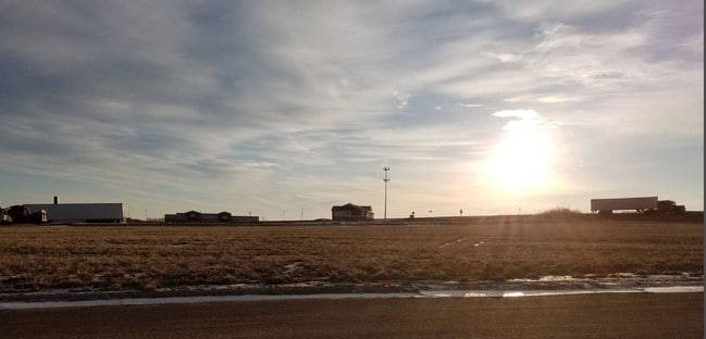
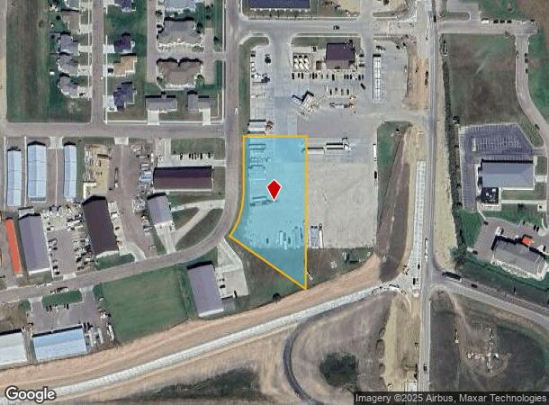
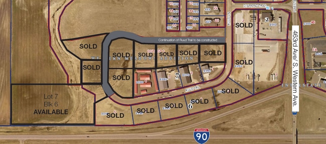
1050 Ruud Trl
Sioux Falls, SD
Meadows Addition
88452
LOT 1 BLOCK 6 WESTERN MEADOWS ADDITION TO THE CITY OF HARTFORD
Commercialacreage
Minnehaha
X
South Dakota
46099C0240D
1
2024
1.95 AC
2024
Sioux Falls
010300
Other Market Areas
DEMOGRAPHICS near 1050 Ruud Trl
1 Mile
3 Mile
5 Mile
2024 Total Population
1,723
4,141
5,157
2029 Population
1,869
4,474
5,567
Pop Growth 2024-2029
+ 8.47%
+ 8.04%
+ 7.95%
Average Age
36
36
37
2024 Total Households
610
1,499
1,854
HH Growth 2024-2029
+ 8.85%
+ 8.34%
+ 8.31%
Median Household Inc
$100,615
$95,312
$98,977
Avg Household Size
2.80
2.80
2.80
2024 Avg HH Vehicles
2.00
2.00
2.00
Median Home Value
$289,150
$255,350
$288,307
Median Year Built
1999
1994
1992
Nearby Places
Map Layers
Map Styles
 Street
 Aerial
- Restaurants
- Banks
- Shops
- Fitness
- Groceries
PUBLIC TRANSPORTATION
AIRPORT
Joe Foss Field
DRIVE
WALK
Distance
Joe Foss Field
33 min
16.4 mi
Freight Ports
Port Milwaukee
DRIVE
WALK
Distance
Port Milwaukee
554 min
511.9 mi
SALE & LEASE HISTORY
LISTING DATE
SALE/LEASE

Nov 07, 2016
For Sale
Nearby Properties
Address
Land Use
TOTAL SIZE
Lot Size
Zoning
Address
Land Use
TOTAL SIZE
Lot Size
Zoning
67,821 SF
9.81 AC
Address
Land Use
TOTAL SIZE
Lot Size
Zoning
46,948 SF
2.21 AC
Address
Land Use
TOTAL SIZE
Lot Size
Zoning
4,040 SF
11.70 AC
A1
Address
Land Use
TOTAL SIZE
Lot Size
Zoning
28,376 SF
2 AC
Address
Land Use
TOTAL SIZE
Lot Size
Zoning
60,660 SF
18 AC
Address
Land Use
TOTAL SIZE
Lot Size
Zoning
2,974 SF
74.04 AC
Address
Land Use
TOTAL SIZE
Lot Size
Zoning
19,088 SF
2.39 AC
Address
Land Use
TOTAL SIZE
Lot Size
Zoning
16,992 SF
1.76 AC
Address
Land Use
TOTAL SIZE
Lot Size
Zoning
19,552 SF
1.13 AC
Address
Land Use
TOTAL SIZE
Lot Size
Zoning
1,056 SF
3.90 AC
NO;SPECIAL
Address
Land Use
TOTAL SIZE
Lot Size
Zoning
2.08 AC
Address
Land Use
TOTAL SIZE
Lot Size
Zoning
15,080 SF
1.80 AC
Address
Land Use
TOTAL SIZE
Lot Size
Zoning
14,820 SF
1.87 AC
Address
Land Use
TOTAL SIZE
Lot Size
Zoning
17,048 SF
1.84 AC
Address
Land Use
TOTAL SIZE
Lot Size
Zoning
8,961 SF
6.56 AC
Address
Land Use
TOTAL SIZE
Lot Size
Zoning
56.06 AC
Address
Land Use
TOTAL SIZE
Lot Size
Zoning
16,470 SF
1.33 AC
Address
Land Use
TOTAL SIZE
Lot Size
Zoning
15,400 SF
2.14 AC
Address
Land Use
TOTAL SIZE
Lot Size
Zoning
14,256 SF
0.81 AC
Address
Land Use
TOTAL SIZE
Lot Size
Zoning
10,252 SF
0.42 AC
Address
Land Use
TOTAL SIZE
Lot Size
Zoning
14,244 SF
0.70 AC
Address
Land Use
TOTAL SIZE
Lot Size
Zoning
11,264 SF
0.98 AC
Address
Land Use
TOTAL SIZE
Lot Size
Zoning
11,226 SF
0.87 AC
Address
Land Use
TOTAL SIZE
Lot Size
Zoning
10,800 SF
0.84 AC
Address
Land Use
TOTAL SIZE
Lot Size
Zoning
1.25 AC
Address
Land Use
TOTAL SIZE
Lot Size
Zoning
7,600 SF
1.84 AC
Address
Land Use
TOTAL SIZE
Lot Size
Zoning
7.17 AC
Address
Land Use
TOTAL SIZE
Lot Size
Zoning
1.36 AC
Address
Land Use
TOTAL SIZE
Lot Size
Zoning
7,876 SF
0.94 AC
Address
Land Use
TOTAL SIZE
Lot Size
Zoning
10,080 SF
1.18 AC
The World's #1 Commercial Real Estate Marketplace
Connect with us
© 2025 CoStar Group
The information above has been obtained from sources believed reliable. While we do not doubt its accuracy we have not verified it and make no guarantee, warranty or representation about it. It is your responsibility to independently confirm its accuracy and completeness. Any projections, opinions, assumptions, or estimates used are for example only and do not represent the current or future performance of the property. The value of this transaction to you depends on tax and other factors which should be evaluated by your tax, financial, and legal advisors. You and your advisors should conduct a careful, independent investigation of the property to determine to your satisfaction the suitability of the property for your needs.