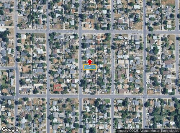
Property Record
1050 S Quitman St, Denver, CO 80219
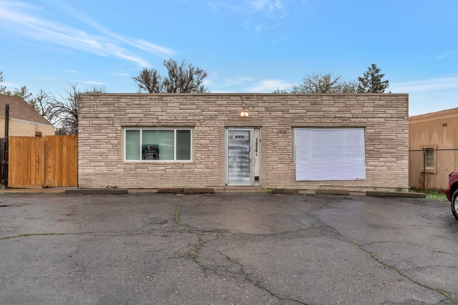
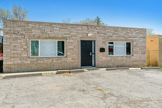
This Property Is For Sale
NEARBY LISTINGS FOR SALE OR LEASE
Property Detail
1050 S Quitman St
Denver-Aurora-Centennial, CO
Kentucky Gardens
5184-29-007
L 13 & 14 BLK 14 KENTUCKY GARDENS ANNEX
Warehouse
Denver
X
Colorado
08059C0308F
13,14
2024
0.15 AC
2025
Upper South Central
004503
Denver
2,873 SF
DEMOGRAPHICS near 1050 S Quitman St
1 mile
3 mile
5 mile
2024 Total Population
25,984
158,557
467,822
2029 Population
25,893
158,419
471,105
Pop Growth 2024-2029
(0.35%)
(0.09%)
+ 0.70%
Average Age
36
38
39
2024 Total Households
8,169
59,192
215,896
HH Growth 2024-2029
(0.54%)
(0.14%)
+ 0.87%
Median Household Inc
$51,939
$67,452
$77,575
Avg Household Size
3.00
2.50
2.10
2024 Avg HH Vehicles
2.00
2.00
2.00
Median Home Value
$350,407
$419,143
$540,067
Median Year Built
1956
1962
1970
Nearby Places
Map Layers
Map Styles
 Street
 Aerial
Transit
 Traffic
 Biking
Places
Listings with unknown addresses are not visible on the map
- Restaurants
- Banks
- Shops
- Fitness
- Groceries
PUBLIC TRANSPORTATION
COMMUTER RAIL
Union Station: LoDo-Coors Field-16th Street Mall (C Line - Denver Regional Transportation District Light Rail (TheRide), E Line - Denver Regional Transportation District Light Rail (TheRide), W Line - Denver Regional Transportation District Light Rail (TheRide))
Drive
Walk
Distance
Union Station: LoDo-Coors Field-16th Street Mall (C Line - Denver Regional Transportation District Light Rail (TheRide), E Line - Denver Regional Transportation District Light Rail (TheRide), W Line - Denver Regional Transportation District Light Rail (TheRide))
13 min
5.6 mi
Drive
Walk
Distance
13 min
5.6 mi
AIRPORT
Denver International
Drive
Walk
Distance
Denver International
43 min
29.7 mi
Nearby Properties
Address
Land Use
TOTAL SIZE
Lot Size
Zoning
Address
Land Use
TOTAL SIZE
Lot Size
Zoning
472,235 SF
1.98 AC
C-RX
Address
Land Use
TOTAL SIZE
Lot Size
Zoning
297,776 SF
2.88 AC
C-MX
Address
Land Use
TOTAL SIZE
Lot Size
Zoning
200,014 SF
5.14 AC
I-MX-3
Address
Land Use
TOTAL SIZE
Lot Size
Zoning
169,731 SF
0.69 AC
C-RX
Address
Land Use
TOTAL SIZE
Lot Size
Zoning
101,906 SF
2.30 AC
C-RX
Address
Land Use
TOTAL SIZE
Lot Size
Zoning
76,877 SF
1.45 AC
C-RX
Address
Land Use
TOTAL SIZE
Lot Size
Zoning
113,932 SF
9.60 AC
I-B
Address
Land Use
TOTAL SIZE
Lot Size
Zoning
323,426 SF
29.84 AC
I-B
Address
Land Use
TOTAL SIZE
Lot Size
Zoning
333,925 SF
3.34 AC
C-MX-5
Address
Land Use
TOTAL SIZE
Lot Size
Zoning
70,944 SF
1.08 AC
C-RX
Address
Land Use
TOTAL SIZE
Lot Size
Zoning
381 SF
66.05 AC
I-B
Address
Land Use
TOTAL SIZE
Lot Size
Zoning
362,988 SF
4.71 AC
T-MU-30
Address
Land Use
TOTAL SIZE
Lot Size
Zoning
34,642 SF
C-MX-8
Address
Land Use
TOTAL SIZE
Lot Size
Zoning
304,560 SF
23.94 AC
S-SU-F
Address
Land Use
TOTAL SIZE
Lot Size
Zoning
67,603 SF
24.89 AC
I-B
Address
Land Use
TOTAL SIZE
Lot Size
Zoning
199,685 SF
27.73 AC
Address
Land Use
TOTAL SIZE
Lot Size
Zoning
341,493 SF
4.22 AC
T-MU-30
Address
Land Use
TOTAL SIZE
Lot Size
Zoning
356,004 SF
4.59 AC
C-MX-12
Address
Land Use
TOTAL SIZE
Lot Size
Zoning
180,689 SF
2.67 AC
I-A
Address
Land Use
TOTAL SIZE
Lot Size
Zoning
115,078 SF
7.61 AC
C-MX-16
Address
Land Use
TOTAL SIZE
Lot Size
Zoning
368,527 SF
18.71 AC
S-SU-D
Address
Land Use
TOTAL SIZE
Lot Size
Zoning
175,000 SF
2.99 AC
C-MU-30
Address
Land Use
TOTAL SIZE
Lot Size
Zoning
4.35 AC
I-B
Address
Land Use
TOTAL SIZE
Lot Size
Zoning
307,325 SF
5.35 AC
C-RX-5
Address
Land Use
TOTAL SIZE
Lot Size
Zoning
339,907 SF
11.18 AC
I-A
Address
Land Use
TOTAL SIZE
Lot Size
Zoning
238,452 SF
8.03 AC
Address
Land Use
TOTAL SIZE
Lot Size
Zoning
324,531 SF
14.97 AC
I-A
Address
Land Use
TOTAL SIZE
Lot Size
Zoning
174,850 SF
17.21 AC
I-A
Address
Land Use
TOTAL SIZE
Lot Size
Zoning
310,910 SF
2.68 AC
C-MX-16
Address
Land Use
TOTAL SIZE
Lot Size
Zoning
70,662 SF
0.13 AC
I-A
The World's #1 Commercial Real Estate Marketplace
Connect with us
© 2026 CoStar Group
The information above has been obtained from sources believed reliable. While we do not doubt its accuracy we have not verified it and make no guarantee, warranty or representation about it. It is your responsibility to independently confirm its accuracy and completeness. Any projections, opinions, assumptions, or estimates used are for example only and do not represent the current or future performance of the property. The value of this transaction to you depends on tax and other factors which should be evaluated by your tax, financial, and legal advisors. You and your advisors should conduct a careful, independent investigation of the property to determine to your satisfaction the suitability of the property for your needs.