Property Record
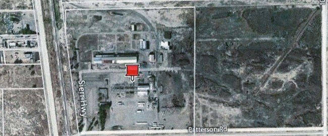
1050 Sierra Hwy, Rosamond, CA 93560

NEARBY LISTINGS FOR SALE OR LEASE
Property Detail
1050 Sierra Hwy
473-023-17-00-5
SECTION 28 , TOWNSHIP 9 , RANGE 12 , QUARTER
Lightindustrial
Kern
X
California
06029C4025E
39.28 AC
2024
SE Outlying Kern County
2025
Bakersfield
005514
Bakersfield, CA
DEMOGRAPHICS near 1050 Sierra Hwy
1 Mile
3 Mile
5 Mile
2024 Total Population
915
17,631
20,508
2029 Population
926
17,731
20,657
Pop Growth 2024-2029
+ 1.20%
+ 0.57%
+ 0.73%
Average Age
34
34
35
2024 Total Households
316
5,926
6,937
HH Growth 2024-2029
+ 0.95%
+ 0.42%
+ 0.59%
Median Household Inc
$21,939
$68,620
$70,309
Avg Household Size
2.80
2.90
2.90
2024 Avg HH Vehicles
2.00
2.00
2.00
Median Home Value
$92,646
$283,729
$280,842
Median Year Built
1994
1993
1993
Nearby Places
Map Layers
Map Styles
 Street
 Aerial
- Restaurants
- Banks
- Shops
- Fitness
- Groceries
PUBLIC TRANSPORTATION
COMMUTER RAIL
Lancaster (Antelope Valley Line - Southern California Regional Rail Authority (Metrolink))
DRIVE
WALK
Distance
Lancaster (Antelope Valley Line - Southern California Regional Rail Authority (Metrolink))
16 min
9.8 mi
Freight Ports
Port of Long Beach
DRIVE
WALK
Distance
Port of Long Beach
121 min
104.1 mi
SALE & LEASE HISTORY
LISTING DATE
SALE/LEASE

Sep 24, 2016
For Sale
Aug 04, 2017
For Sale
Nearby Properties
Address
Land Use
TOTAL SIZE
Lot Size
Zoning
Address
Land Use
TOTAL SIZE
Lot Size
Zoning
59,719 SF
7.33 AC
R-1
Address
Land Use
TOTAL SIZE
Lot Size
Zoning
78,737 SF
2.73 AC
C2
Address
Land Use
TOTAL SIZE
Lot Size
Zoning
17,253 SF
2.91 AC
C2
Address
Land Use
TOTAL SIZE
Lot Size
Zoning
11,575 SF
4.16 AC
R3
Address
Land Use
TOTAL SIZE
Lot Size
Zoning
Address
Land Use
TOTAL SIZE
Lot Size
Zoning
47,337 SF
3.65 AC
C2
Address
Land Use
TOTAL SIZE
Lot Size
Zoning
12,240 SF
5.30 AC
M-2
Address
Land Use
TOTAL SIZE
Lot Size
Zoning
Address
Land Use
TOTAL SIZE
Lot Size
Zoning
19,519 SF
9.32 AC
M-3
Address
Land Use
TOTAL SIZE
Lot Size
Zoning
22,352 SF
8.64 AC
M-3
Address
Land Use
TOTAL SIZE
Lot Size
Zoning
4,951 SF
1.49 AC
C1
Address
Land Use
TOTAL SIZE
Lot Size
Zoning
Address
Land Use
TOTAL SIZE
Lot Size
Zoning
31,608 SF
2.72 AC
R-1
Address
Land Use
TOTAL SIZE
Lot Size
Zoning
21,000 SF
2.44 AC
C-2 PD
Address
Land Use
TOTAL SIZE
Lot Size
Zoning
9,209 SF
1.80 AC
C2 PD FPS
Address
Land Use
TOTAL SIZE
Lot Size
Zoning
27,340 SF
1.54 AC
R-3 PD
Address
Land Use
TOTAL SIZE
Lot Size
Zoning
27,340 SF
1.54 AC
R-3 PD
Address
Land Use
TOTAL SIZE
Lot Size
Zoning
9,350 SF
0.73 AC
R-3
Address
Land Use
TOTAL SIZE
Lot Size
Zoning
2,400 SF
0.82 AC
M-1
Address
Land Use
TOTAL SIZE
Lot Size
Zoning
Address
Land Use
TOTAL SIZE
Lot Size
Zoning
1,120 SF
6.17 AC
M2
Address
Land Use
TOTAL SIZE
Lot Size
Zoning
1,913 SF
0.96 AC
C-2 PD
Address
Land Use
TOTAL SIZE
Lot Size
Zoning
2.13 AC
C-2 PD
Address
Land Use
TOTAL SIZE
Lot Size
Zoning
9,100 SF
1.02 AC
C-2
Address
Land Use
TOTAL SIZE
Lot Size
Zoning
4,530 SF
0.84 AC
C2
Address
Land Use
TOTAL SIZE
Lot Size
Zoning
1,842 SF
2.55 AC
R-3 PD FPS
Address
Land Use
TOTAL SIZE
Lot Size
Zoning
4.27 AC
R-3 PD
Address
Land Use
TOTAL SIZE
Lot Size
Zoning
5.58 AC
R-1
Address
Land Use
TOTAL SIZE
Lot Size
Zoning
28.93 AC
M-2
Address
Land Use
TOTAL SIZE
Lot Size
Zoning
7,378 SF
0.66 AC
C-2
The World's #1 Commercial Real Estate Marketplace
Connect with us
© 2025 CoStar Group
The information above has been obtained from sources believed reliable. While we do not doubt its accuracy we have not verified it and make no guarantee, warranty or representation about it. It is your responsibility to independently confirm its accuracy and completeness. Any projections, opinions, assumptions, or estimates used are for example only and do not represent the current or future performance of the property. The value of this transaction to you depends on tax and other factors which should be evaluated by your tax, financial, and legal advisors. You and your advisors should conduct a careful, independent investigation of the property to determine to your satisfaction the suitability of the property for your needs.