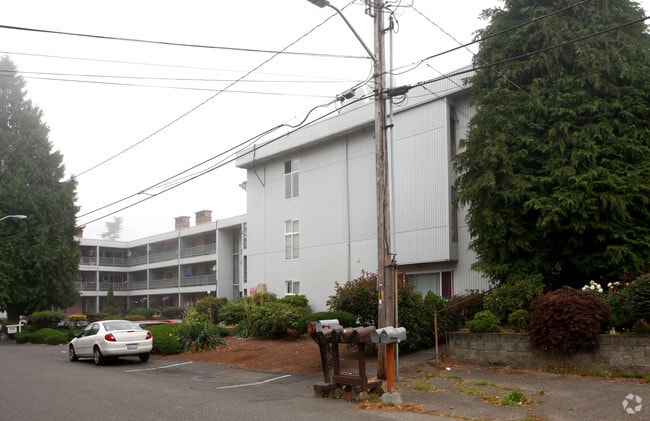
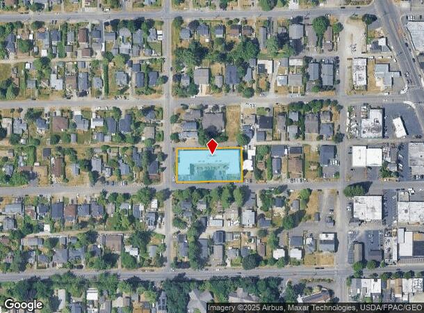
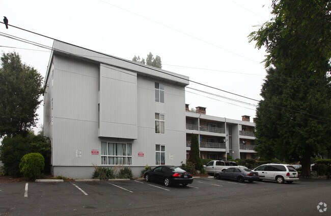
Property Record
1050 Sw 151St St, Burien, WA 98166
NEARBY LISTINGS FOR SALE OR LEASE
-
-
-
-
-
No Photo
-
-
-
View all Burien listings for sale on LoopNet.com
Property Detail
1050 Sw 151St St
Seattle-Tacoma-Bellevue, WA
Dashleys Add No. 02
190000-0135
DASHLEYS ADD # 2
Apartment
King
X
Washington
53033C0953G
7-8-1
2025
0.72 AC
2024
Lake Burien
027902
Seattle/Puget Sound
25,396 SF
DEMOGRAPHICS near 1050 Sw 151St St
1 Mile
3 Mile
5 Mile
2024 Total Population
14,531
78,819
190,970
2029 Population
14,621
79,245
191,742
Pop Growth 2024-2029
+ 0.62%
+ 0.54%
+ 0.40%
Average Age
42
40
40
2024 Total Households
6,052
28,925
71,330
HH Growth 2024-2029
+ 0.51%
+ 0.34%
+ 0.18%
Median Household Inc
$89,023
$90,112
$86,072
Avg Household Size
2.30
2.60
2.50
2024 Avg HH Vehicles
2.00
2.00
2.00
Median Home Value
$726,884
$624,258
$627,862
Median Year Built
1965
1965
1967
Nearby Places
Map Layers
Map Styles
 Street
 Aerial
- Restaurants
- Banks
- Shops
- Fitness
- Groceries
PUBLIC TRANSPORTATION
COMMUTER RAIL
Tukwila Station (Seattle - Tacoma/Lakewood - Sound Transit, Sounder South Line - Sound Transit)
DRIVE
WALK
Distance
Tukwila Station (Seattle - Tacoma/Lakewood - Sound Transit, Sounder South Line - Sound Transit)
10 min
5.9 mi
AIRPORT
Seattle-Tacoma International
DRIVE
WALK
Distance
Seattle-Tacoma International
10 min
4.5 mi
Freight Ports
Port of Seattle
DRIVE
WALK
Distance
Port of Seattle
18 min
9.3 mi
Nearby Properties
Address
Land Use
TOTAL SIZE
Lot Size
Zoning
Address
Land Use
TOTAL SIZE
Lot Size
Zoning
31,032 SF
1,746.88 AC
AVO
Address
Land Use
TOTAL SIZE
Lot Size
Zoning
704,186 SF
21.86 AC
I
Address
Land Use
TOTAL SIZE
Lot Size
Zoning
230,950 SF
6.56 AC
CBP
Address
Land Use
TOTAL SIZE
Lot Size
Zoning
139,868 SF
6.64 AC
O
Address
Land Use
TOTAL SIZE
Lot Size
Zoning
463,722 SF
25.21 AC
RM-18
Address
Land Use
TOTAL SIZE
Lot Size
Zoning
130,200 SF
9.55 AC
CB-C
Address
Land Use
TOTAL SIZE
Lot Size
Zoning
325,494 SF
23.53 AC
AI-2
Address
Land Use
TOTAL SIZE
Lot Size
Zoning
236,919 SF
13.40 AC
AI-1
Address
Land Use
TOTAL SIZE
Lot Size
Zoning
256,409 SF
17.60 AC
RS-7200
Address
Land Use
TOTAL SIZE
Lot Size
Zoning
19,008 SF
12.79 AC
RBX
Address
Land Use
TOTAL SIZE
Lot Size
Zoning
140,000 SF
19.42 AC
UL-7200
Address
Land Use
TOTAL SIZE
Lot Size
Zoning
185,925 SF
6.45 AC
RM-24
Address
Land Use
TOTAL SIZE
Lot Size
Zoning
153,668 SF
6.90 AC
RM-24
Address
Land Use
TOTAL SIZE
Lot Size
Zoning
24,240 SF
8 AC
DC
Address
Land Use
TOTAL SIZE
Lot Size
Zoning
132,662 SF
2.38 AC
CB-C
Address
Land Use
TOTAL SIZE
Lot Size
Zoning
115,736 SF
4.63 AC
R48DPA
Address
Land Use
TOTAL SIZE
Lot Size
Zoning
103,680 SF
3.82 AC
RM-48
Address
Land Use
TOTAL SIZE
Lot Size
Zoning
135,875 SF
9.09 AC
AI-1
Address
Land Use
TOTAL SIZE
Lot Size
Zoning
104,202 SF
5.23 AC
RM-24
Address
Land Use
TOTAL SIZE
Lot Size
Zoning
24,204 SF
30.53 AC
R6
Address
Land Use
TOTAL SIZE
Lot Size
Zoning
110,452 SF
4.37 AC
RM-24
Address
Land Use
TOTAL SIZE
Lot Size
Zoning
102,548 SF
3.90 AC
R48
Address
Land Use
TOTAL SIZE
Lot Size
Zoning
1,210 SF
1.13 AC
CBP
Address
Land Use
TOTAL SIZE
Lot Size
Zoning
102,672 SF
4.56 AC
R48
Address
Land Use
TOTAL SIZE
Lot Size
Zoning
274,136 SF
0.65 AC
CB-C
Address
Land Use
TOTAL SIZE
Lot Size
Zoning
100,800 SF
7.01 AC
RM-18
Address
Land Use
TOTAL SIZE
Lot Size
Zoning
56,811 SF
8.60 AC
SPA-3
Address
Land Use
TOTAL SIZE
Lot Size
Zoning
16,184 SF
7.73 AC
I
Address
Land Use
TOTAL SIZE
Lot Size
Zoning
1,500 SF
56.31 AC
P
The World's #1 Commercial Real Estate Marketplace
Connect with us
© 2025 CoStar Group
The information above has been obtained from sources believed reliable. While we do not doubt its accuracy we have not verified it and make no guarantee, warranty or representation about it. It is your responsibility to independently confirm its accuracy and completeness. Any projections, opinions, assumptions, or estimates used are for example only and do not represent the current or future performance of the property. The value of this transaction to you depends on tax and other factors which should be evaluated by your tax, financial, and legal advisors. You and your advisors should conduct a careful, independent investigation of the property to determine to your satisfaction the suitability of the property for your needs.