Property Record
1050 W 6Th St, Corona, CA 92882
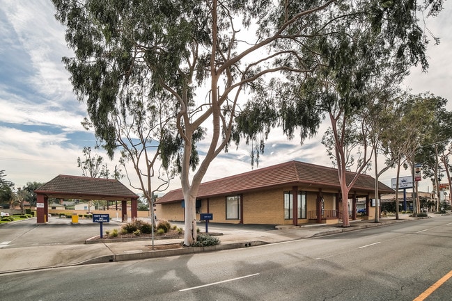

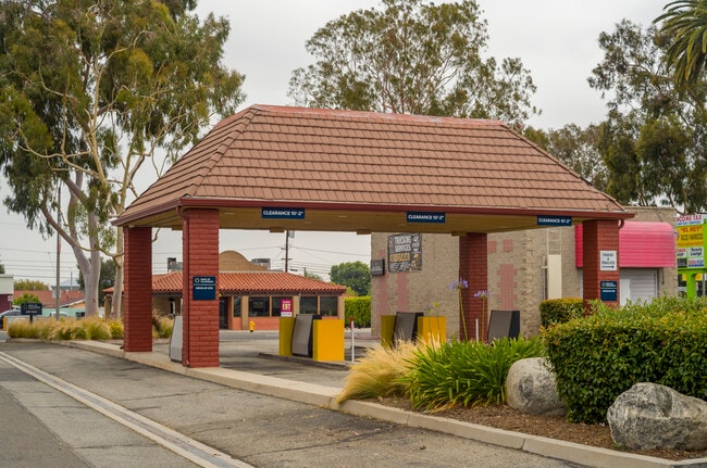

This Property Is For Sale
Property Detail
1050 W 6Th St
110-062-013
.65 ACRES M/L IN POR LOTS 6, 7 & 8 MB 011/001 ELZIE VEACHS FAIRVIEW TR
Financialbuilding
Riverside
C3
California
C and X Area of minimal flood hazard, usually depicted on FIRMs as above the 500-year flood level.
8
2024
0.65 AC
2025
Corona/Eastvale
041704
Inland Empire (California)
6,018 SF
Riverside-San Bernardino-Ontario, CA
NEARBY LISTINGS FOR SALE OR LEASE
DEMOGRAPHICS near 1050 W 6Th St
1 mile
3 mile
5 mile
2025 Total Population
22,867
120,956
200,077
2030 Population
23,214
122,770
203,291
Pop Growth 2025-2030
+ 1.52%
+ 1.50%
+ 1.61%
Average Age
35
37
38
2025 Total Households
6,481
34,881
57,168
HH Growth 2025-2030
+ 0.99%
+ 0.97%
+ 1.10%
Median Household Inc
$71,994
$102,337
$111,049
Avg Household Size
3.40
3.20
3.30
2025 Avg HH Vehicles
2.00
2.00
3.00
Median Home Value
$646,910
$724,478
$731,930
Median Year Built
1975
1985
1987
Nearby Places
Map Layers
Map Styles
 Street
 Aerial
Layers
 Traffic
 Biking
Places
Listings with unknown addresses are not visible on the map
- Restaurants
- Banks
- Shops
- Fitness
- Groceries
PUBLIC TRANSPORTATION
COMMUTER RAIL
North Main Corona (91 Line - Southern California Regional Rail Authority (Metrolink), Inland Empire-Orange County Line - Southern California Regional Rail Authority (Metrolink))
Drive
Walk
Distance
North Main Corona (91 Line - Southern California Regional Rail Authority (Metrolink), Inland Empire-Orange County Line - Southern California Regional Rail Authority (Metrolink))
4 min
1.9 mi
West Corona (91 Line - Southern California Regional Rail Authority (Metrolink), Inland Empire-Orange County Line - Southern California Regional Rail Authority (Metrolink))
Drive
Walk
Distance
West Corona (91 Line - Southern California Regional Rail Authority (Metrolink), Inland Empire-Orange County Line - Southern California Regional Rail Authority (Metrolink))
6 min
2.7 mi
AIRPORT
Ontario International
Drive
Walk
Distance
Ontario International
24 min
15.8 mi
John Wayne/Orange County
Drive
Walk
Distance
John Wayne/Orange County
35 min
27.7 mi
Long Beach (Daugherty Field)
Drive
Walk
Distance
Long Beach (Daugherty Field)
51 min
42.2 mi
Freight Ports
Port of Long Beach
Drive
Walk
Distance
Port of Long Beach
57 min
41.7 mi
Nearby Properties
Address
Land Use
TOTAL SIZE
Lot Size
Zoning
Address
Land Use
TOTAL SIZE
Lot Size
Zoning
12.69 AC
Address
Land Use
TOTAL SIZE
Lot Size
Zoning
91,619 SF
12.54 AC
HDR
Address
Land Use
TOTAL SIZE
Lot Size
Zoning
29,695 SF
18.71 AC
R3
Address
Land Use
TOTAL SIZE
Lot Size
Zoning
263,872 SF
12.87 AC
Address
Land Use
TOTAL SIZE
Lot Size
Zoning
289,297 SF
13.28 AC
M3
Address
Land Use
TOTAL SIZE
Lot Size
Zoning
186,190 SF
9.79 AC
Address
Land Use
TOTAL SIZE
Lot Size
Zoning
164,712 SF
10 AC
R3
Address
Land Use
TOTAL SIZE
Lot Size
Zoning
173,676 SF
10.96 AC
R3
Address
Land Use
TOTAL SIZE
Lot Size
Zoning
24,144 SF
13.34 AC
R3
Address
Land Use
TOTAL SIZE
Lot Size
Zoning
245,658 SF
15.38 AC
PD
Address
Land Use
TOTAL SIZE
Lot Size
Zoning
182,066 SF
9.31 AC
Address
Land Use
TOTAL SIZE
Lot Size
Zoning
8.80 AC
R3
Address
Land Use
TOTAL SIZE
Lot Size
Zoning
421,898 SF
3 AC
Address
Land Use
TOTAL SIZE
Lot Size
Zoning
217,299 SF
7.41 AC
Address
Land Use
TOTAL SIZE
Lot Size
Zoning
141,280 SF
9.31 AC
Address
Land Use
TOTAL SIZE
Lot Size
Zoning
171,707 SF
8.55 AC
Address
Land Use
TOTAL SIZE
Lot Size
Zoning
149,389 SF
6.72 AC
Address
Land Use
TOTAL SIZE
Lot Size
Zoning
152,756 SF
7.07 AC
Address
Land Use
TOTAL SIZE
Lot Size
Zoning
159,517 SF
7.81 AC
Address
Land Use
TOTAL SIZE
Lot Size
Zoning
138,800 SF
10 AC
M4
Address
Land Use
TOTAL SIZE
Lot Size
Zoning
140,216 SF
6.43 AC
Address
Land Use
TOTAL SIZE
Lot Size
Zoning
145,424 SF
7.23 AC
Address
Land Use
TOTAL SIZE
Lot Size
Zoning
111,862 SF
9.98 AC
A
Address
Land Use
TOTAL SIZE
Lot Size
Zoning
357,900 SF
18.93 AC
Address
Land Use
TOTAL SIZE
Lot Size
Zoning
311,297 SF
13.39 AC
Address
Land Use
TOTAL SIZE
Lot Size
Zoning
364,162 SF
10 AC
M4
Address
Land Use
TOTAL SIZE
Lot Size
Zoning
482,479 SF
26.14 AC
M2
Address
Land Use
TOTAL SIZE
Lot Size
Zoning
63,130 SF
10.20 AC
R3
Address
Land Use
TOTAL SIZE
Lot Size
Zoning
203,476 SF
10.40 AC
C3
Address
Land Use
TOTAL SIZE
Lot Size
Zoning
105,813 SF
3.54 AC
The World's #1 Commercial Real Estate Marketplace
Connect with us
© 2026 CoStar Group
The information above has been obtained from sources believed reliable. While we do not doubt its accuracy we have not verified it and make no guarantee, warranty or representation about it. It is your responsibility to independently confirm its accuracy and completeness. Any projections, opinions, assumptions, or estimates used are for example only and do not represent the current or future performance of the property. The value of this transaction to you depends on tax and other factors which should be evaluated by your tax, financial, and legal advisors. You and your advisors should conduct a careful, independent investigation of the property to determine to your satisfaction the suitability of the property for your needs.