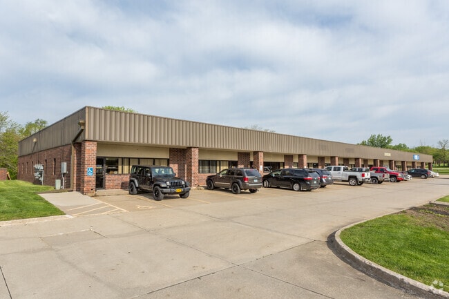
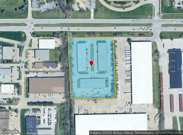
Property Record
10500 Hickman Rd, Clive, IA 50325

Current Lease Availabilities
NEARBY LISTINGS FOR SALE OR LEASE
Property Detail
10500 Hickman Rd
291-00369428011
Interstate Investment Subdivision
Radioortvstationcommunications
BLDG & TOWER ON LSD LAND BNG -EX S 70F- BEG 437.11F W OF NE COR THN W 444.26F S 672.12F E 430.87F N 662.28F TO POB OL Y INTERSTATE INVESTMENT SD
A
Polk
19153C0310F
Iowa
2024
Western Suburbs
2025
Des Moines
011206
Des Moines-West Des Moines, IA
372 SF
DEMOGRAPHICS near 10500 Hickman Rd
1 Mile
3 Mile
5 Mile
2024 Total Population
2,847
67,374
195,966
2029 Population
2,942
70,340
212,019
Pop Growth 2024-2029
+ 3.34%
+ 4.40%
+ 8.19%
Average Age
44
40
39
2024 Total Households
1,180
27,930
81,443
HH Growth 2024-2029
+ 3.47%
+ 4.55%
+ 8.33%
Median Household Inc
$111,759
$84,804
$84,868
Avg Household Size
2.40
2.40
2.40
2024 Avg HH Vehicles
2.00
2.00
2.00
Median Home Value
$262,903
$262,884
$261,902
Median Year Built
1979
1982
1989
Nearby Places
Map Layers
Map Styles
 Street
 Aerial
- Restaurants
- Banks
- Shops
- Fitness
- Groceries
PUBLIC TRANSPORTATION
AIRPORT
Des Moines International
DRIVE
WALK
Distance
Des Moines International
22 min
10.3 mi
Freight Ports
Port Milwaukee
DRIVE
WALK
Distance
Port Milwaukee
424 min
381.4 mi
Nearby Properties
Address
Land Use
TOTAL SIZE
Lot Size
Zoning
Address
Land Use
TOTAL SIZE
Lot Size
Zoning
472,476 SF
12.48 AC
PUD OFFICE
Address
Land Use
TOTAL SIZE
Lot Size
Zoning
18,093 SF
48.92 AC
Address
Land Use
TOTAL SIZE
Lot Size
Zoning
255,521 SF
60.90 AC
RE
Address
Land Use
TOTAL SIZE
Lot Size
Zoning
422,683 SF
46.57 AC
PCP
Address
Land Use
TOTAL SIZE
Lot Size
Zoning
457,056 SF
26.01 AC
Address
Land Use
TOTAL SIZE
Lot Size
Zoning
407,183 SF
17.02 AC
PUD
Address
Land Use
TOTAL SIZE
Lot Size
Zoning
415,320 SF
51.16 AC
PUD
Address
Land Use
TOTAL SIZE
Lot Size
Zoning
241,324 SF
21.67 AC
PUD B&C
Address
Land Use
TOTAL SIZE
Lot Size
Zoning
322,220 SF
7.61 AC
Address
Land Use
TOTAL SIZE
Lot Size
Zoning
275,227 SF
18.31 AC
PCP
Address
Land Use
TOTAL SIZE
Lot Size
Zoning
196,904 SF
26.10 AC
PUD
Address
Land Use
TOTAL SIZE
Lot Size
Zoning
387,456 SF
15.72 AC
PUD HD
Address
Land Use
TOTAL SIZE
Lot Size
Zoning
22,093 SF
12.26 AC
Address
Land Use
TOTAL SIZE
Lot Size
Zoning
182,866 SF
10.21 AC
Address
Land Use
TOTAL SIZE
Lot Size
Zoning
189,691 SF
27.03 AC
PCP
Address
Land Use
TOTAL SIZE
Lot Size
Zoning
572,809 SF
42.13 AC
M-2
Address
Land Use
TOTAL SIZE
Lot Size
Zoning
367,386 SF
24.31 AC
PUD
Address
Land Use
TOTAL SIZE
Lot Size
Zoning
341,024 SF
12.15 AC
RH
Address
Land Use
TOTAL SIZE
Lot Size
Zoning
67,691 SF
7.30 AC
Address
Land Use
TOTAL SIZE
Lot Size
Zoning
151,344 SF
10.43 AC
C-3
Address
Land Use
TOTAL SIZE
Lot Size
Zoning
280,396 SF
34.25 AC
Address
Land Use
TOTAL SIZE
Lot Size
Zoning
195,931 SF
13.66 AC
Address
Land Use
TOTAL SIZE
Lot Size
Zoning
221,654 SF
26.38 AC
PUD MD
Address
Land Use
TOTAL SIZE
Lot Size
Zoning
83,370 SF
0.98 AC
C-3
Address
Land Use
TOTAL SIZE
Lot Size
Zoning
79,916 SF
7.82 AC
PUD OFFICE
Address
Land Use
TOTAL SIZE
Lot Size
Zoning
308,117 SF
18.33 AC
RH
Address
Land Use
TOTAL SIZE
Lot Size
Zoning
80,045 SF
5.07 AC
C-3
Address
Land Use
TOTAL SIZE
Lot Size
Zoning
168,898 SF
17.54 AC
PUD
Address
Land Use
TOTAL SIZE
Lot Size
Zoning
235,620 SF
13.18 AC
RH
Address
Land Use
TOTAL SIZE
Lot Size
Zoning
212,500 SF
10.20 AC
The World's #1 Commercial Real Estate Marketplace
Connect with us
© 2026 CoStar Group
The information above has been obtained from sources believed reliable. While we do not doubt its accuracy we have not verified it and make no guarantee, warranty or representation about it. It is your responsibility to independently confirm its accuracy and completeness. Any projections, opinions, assumptions, or estimates used are for example only and do not represent the current or future performance of the property. The value of this transaction to you depends on tax and other factors which should be evaluated by your tax, financial, and legal advisors. You and your advisors should conduct a careful, independent investigation of the property to determine to your satisfaction the suitability of the property for your needs.