Property Record
10500 Macarthur Blvd, Oakland, CA 94605
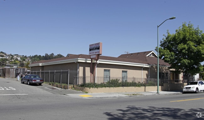


This Property Is For Sale
NEARBY LISTINGS FOR SALE OR LEASE
Property Detail
10500 Macarthur Blvd
Oakland-Hayward-Berkeley, CA
Iveywood Ext
047-5595-022-08
PORTION MYERS STREET
Medicalbuilding
Alameda
X
California
06001C0257G
10,1&
2024
0.32 AC
2025
Oakland-South/Airport
410100
East Bay/Oakland
4,184 SF
DEMOGRAPHICS near 10500 Macarthur Blvd
1 Mile
3 Mile
5 Mile
2024 Total Population
28,070
159,198
355,549
2029 Population
27,111
153,596
342,928
Pop Growth 2024-2029
(3.42%)
(3.52%)
(3.55%)
Average Age
39
39
40
2024 Total Households
9,295
51,314
116,525
HH Growth 2024-2029
(3.61%)
(3.72%)
(3.76%)
Median Household Inc
$84,456
$76,544
$84,428
Avg Household Size
2.90
2.90
2.90
2024 Avg HH Vehicles
2.00
2.00
2.00
Median Home Value
$727,681
$709,760
$765,773
Median Year Built
1950
1955
1955
Nearby Places
Map Layers
Map Styles
 Street
 Aerial
- Restaurants
- Banks
- Shops
- Fitness
- Groceries
PUBLIC TRANSPORTATION
COMMUTER RAIL
DRIVE
WALK
Distance
13 min
7.5 mi
DRIVE
WALK
Distance
13 min
7.5 mi
AIRPORT
Metro Oakland International
DRIVE
WALK
Distance
Metro Oakland International
10 min
5.1 mi
San Francisco International
DRIVE
WALK
Distance
San Francisco International
39 min
29.2 mi
Norman Y Mineta San Jose International
DRIVE
WALK
Distance
Norman Y Mineta San Jose International
43 min
33.8 mi
Freight Ports
Port of Oakland
DRIVE
WALK
Distance
Port of Oakland
15 min
9.7 mi
Nearby Properties
Address
Land Use
TOTAL SIZE
Lot Size
Zoning
Address
Land Use
TOTAL SIZE
Lot Size
Zoning
298,256 SF
12.16 AC
Address
Land Use
TOTAL SIZE
Lot Size
Zoning
165,923 SF
14.99 AC
Address
Land Use
TOTAL SIZE
Lot Size
Zoning
597,179 SF
19.16 AC
Address
Land Use
TOTAL SIZE
Lot Size
Zoning
726,931 SF
37.03 AC
Address
Land Use
TOTAL SIZE
Lot Size
Zoning
713,010 SF
19.96 AC
Address
Land Use
TOTAL SIZE
Lot Size
Zoning
1.64 AC
Address
Land Use
TOTAL SIZE
Lot Size
Zoning
525,864 SF
16.53 AC
Address
Land Use
TOTAL SIZE
Lot Size
Zoning
180,959 SF
9.38 AC
Address
Land Use
TOTAL SIZE
Lot Size
Zoning
289,747 SF
11.31 AC
Address
Land Use
TOTAL SIZE
Lot Size
Zoning
203,925 SF
8.54 AC
Address
Land Use
TOTAL SIZE
Lot Size
Zoning
323,080 SF
12.50 AC
I2
Address
Land Use
TOTAL SIZE
Lot Size
Zoning
99,039 SF
1.04 AC
Address
Land Use
TOTAL SIZE
Lot Size
Zoning
235,760 SF
9.52 AC
Address
Land Use
TOTAL SIZE
Lot Size
Zoning
292,698 SF
12.92 AC
Address
Land Use
TOTAL SIZE
Lot Size
Zoning
693,679 SF
43.49 AC
Address
Land Use
TOTAL SIZE
Lot Size
Zoning
294,146 SF
14.22 AC
Address
Land Use
TOTAL SIZE
Lot Size
Zoning
133,974 SF
4.99 AC
Address
Land Use
TOTAL SIZE
Lot Size
Zoning
240,668 SF
14.11 AC
Address
Land Use
TOTAL SIZE
Lot Size
Zoning
241,382 SF
12.72 AC
Address
Land Use
TOTAL SIZE
Lot Size
Zoning
214,062 SF
16.20 AC
Address
Land Use
TOTAL SIZE
Lot Size
Zoning
24.51 AC
Address
Land Use
TOTAL SIZE
Lot Size
Zoning
132,018 SF
1.11 AC
Address
Land Use
TOTAL SIZE
Lot Size
Zoning
168,104 SF
13.73 AC
Address
Land Use
TOTAL SIZE
Lot Size
Zoning
231,756 SF
9.15 AC
Address
Land Use
TOTAL SIZE
Lot Size
Zoning
136,618 SF
6.34 AC
Address
Land Use
TOTAL SIZE
Lot Size
Zoning
155,000 SF
8.41 AC
Address
Land Use
TOTAL SIZE
Lot Size
Zoning
243,524 SF
15.17 AC
Address
Land Use
TOTAL SIZE
Lot Size
Zoning
149,602 SF
6.90 AC
Address
Land Use
TOTAL SIZE
Lot Size
Zoning
232,068 SF
31.82 AC
Address
Land Use
TOTAL SIZE
Lot Size
Zoning
427,400 SF
17.34 AC
The World's #1 Commercial Real Estate Marketplace
Connect with us
© 2025 CoStar Group
The information above has been obtained from sources believed reliable. While we do not doubt its accuracy we have not verified it and make no guarantee, warranty or representation about it. It is your responsibility to independently confirm its accuracy and completeness. Any projections, opinions, assumptions, or estimates used are for example only and do not represent the current or future performance of the property. The value of this transaction to you depends on tax and other factors which should be evaluated by your tax, financial, and legal advisors. You and your advisors should conduct a careful, independent investigation of the property to determine to your satisfaction the suitability of the property for your needs.