Property Record
Situs Not Available, Commerce City, CO 80003
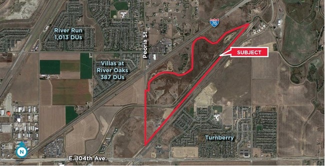
Property Detail
Situs Not Available
Denver-Aurora-Centennial, CO
SECT,TWN,RNG:12-2-67 DESC: PT OF NW4 SEC 12 LYING S AND E OF THE O BRIAN CANAL EXC PARC BEG AT N4 COR OF SEC 12 TH S 0D 36M W 1200 FT ALG N/S C/L TH N 86D 12M W 522/9 FT TH N 00D 38M E 420 FT TH S 86D 24M E 601/8 FT M/L TO TRUE POB EXC HWAY AND EXC P
1721-12-2-00-002
ADAMS
Utilities
Colorado
0
60.40 AC
2025
Northeast Denver
010209
Denver
NEARBY LISTINGS FOR SALE OR LEASE
DEMOGRAPHICS near Situs Not Available
1 mile
3 mile
5 mile
2025 Total Population
6,400
36,037
90,549
2030 Population
6,725
37,968
95,109
Pop Growth 2025-2030
+ 5.08%
+ 5.36%
+ 5.04%
Average Age
34
35
35
2025 Total Households
1,895
11,248
28,482
HH Growth 2025-2030
+ 5.33%
+ 5.65%
+ 5.31%
Median Household Inc
$138,337
$133,492
$128,880
Avg Household Size
3.30
3.20
3.20
2025 Avg HH Vehicles
3.00
2.00
2.00
Median Home Value
$599,753
$572,456
$581,940
Median Year Built
2008
2007
2005
Nearby Places
Map Layers
Map Styles
 Street
 Aerial
Transit
 Traffic
 Biking
Places
Listings with unknown addresses are not visible on the map
- Restaurants
- Banks
- Shops
- Fitness
- Groceries
PUBLIC TRANSPORTATION
COMMUTER RAIL
Thornton Crossroads - 104Th Station Track 1 (Union Station to Eastlake & 124th Station - Regional Transportation District)
Drive
Walk
Distance
Thornton Crossroads - 104Th Station Track 1 (Union Station to Eastlake & 124th Station - Regional Transportation District)
11 min
5.9 mi
Northglenn - 112Th Station Track 2 (Union Station to Eastlake & 124th Station - Regional Transportation District)
Drive
Walk
Distance
Northglenn - 112Th Station Track 2 (Union Station to Eastlake & 124th Station - Regional Transportation District)
14 min
7.7 mi
AIRPORT
Denver International
Drive
Walk
Distance
Denver International
22 min
14.8 mi
Freight Ports
Tulsa Port Of Catoosa
Drive
Walk
Distance
Tulsa Port Of Catoosa
728 min
708.9 mi
SALE & LEASE HISTORY
LISTING DATE
SALE/LEASE

Jul 14, 2017
For Sale
Nearby Properties
Address
Land Use
TOTAL SIZE
Lot Size
Zoning
Address
Land Use
TOTAL SIZE
Lot Size
Zoning
279,946 SF
11.55 AC
Address
Land Use
TOTAL SIZE
Lot Size
Zoning
8,556 SF
382.73 AC
A3
Address
Land Use
TOTAL SIZE
Lot Size
Zoning
358,386 SF
76.08 AC
Address
Land Use
TOTAL SIZE
Lot Size
Zoning
276,395 SF
26.43 AC
A3
Address
Land Use
TOTAL SIZE
Lot Size
Zoning
624.70 AC
A3
Address
Land Use
TOTAL SIZE
Lot Size
Zoning
624.02 AC
A3
Address
Land Use
TOTAL SIZE
Lot Size
Zoning
330,176 SF
17.12 AC
Address
Land Use
TOTAL SIZE
Lot Size
Zoning
298,200 SF
17.67 AC
Address
Land Use
TOTAL SIZE
Lot Size
Zoning
272,800 SF
16.44 AC
Address
Land Use
TOTAL SIZE
Lot Size
Zoning
64,750 SF
11.91 AC
Address
Land Use
TOTAL SIZE
Lot Size
Zoning
121,103 SF
13.47 AC
Address
Land Use
TOTAL SIZE
Lot Size
Zoning
231,205 SF
10.46 AC
Address
Land Use
TOTAL SIZE
Lot Size
Zoning
158,001 SF
20.40 AC
Address
Land Use
TOTAL SIZE
Lot Size
Zoning
Address
Land Use
TOTAL SIZE
Lot Size
Zoning
96,628 SF
4.35 AC
Address
Land Use
TOTAL SIZE
Lot Size
Zoning
140,712 SF
18.29 AC
Address
Land Use
TOTAL SIZE
Lot Size
Zoning
207,682 SF
7.16 AC
Address
Land Use
TOTAL SIZE
Lot Size
Zoning
64,501 SF
29.37 AC
Address
Land Use
TOTAL SIZE
Lot Size
Zoning
121,275 SF
6.56 AC
Address
Land Use
TOTAL SIZE
Lot Size
Zoning
76,279 SF
25.01 AC
Address
Land Use
TOTAL SIZE
Lot Size
Zoning
64,715 SF
10.38 AC
Address
Land Use
TOTAL SIZE
Lot Size
Zoning
106,530 SF
7.04 AC
Address
Land Use
TOTAL SIZE
Lot Size
Zoning
70,573 SF
6.42 AC
Address
Land Use
TOTAL SIZE
Lot Size
Zoning
33,989 SF
24.98 AC
Address
Land Use
TOTAL SIZE
Lot Size
Zoning
63,989 SF
12.74 AC
Address
Land Use
TOTAL SIZE
Lot Size
Zoning
122,399 SF
14.29 AC
Address
Land Use
TOTAL SIZE
Lot Size
Zoning
89,219 SF
11.79 AC
Address
Land Use
TOTAL SIZE
Lot Size
Zoning
44,090 SF
20.72 AC
Address
Land Use
TOTAL SIZE
Lot Size
Zoning
91,505 SF
8.64 AC
Address
Land Use
TOTAL SIZE
Lot Size
Zoning
86,336 SF
16.18 AC
The World's #1 Commercial Real Estate Marketplace
Connect with us
© 2026 CoStar Group
The information above has been obtained from sources believed reliable. While we do not doubt its accuracy we have not verified it and make no guarantee, warranty or representation about it. It is your responsibility to independently confirm its accuracy and completeness. Any projections, opinions, assumptions, or estimates used are for example only and do not represent the current or future performance of the property. The value of this transaction to you depends on tax and other factors which should be evaluated by your tax, financial, and legal advisors. You and your advisors should conduct a careful, independent investigation of the property to determine to your satisfaction the suitability of the property for your needs.