Property Record
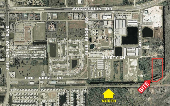
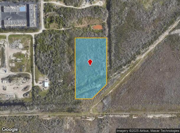
10501 Safety Ln, Fort Myers, FL 33908
This Property Is For Sale
NEARBY LISTINGS FOR SALE OR LEASE
Property Detail
10501 Safety Ln
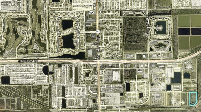
Cape Coral-Fort Myers, FL
Mcgregor / Summerlin
08-46-24-00-00001.0070
PAR IN SE1/4 OF NW1/4 DESC OR 837/802 AKA LOTS 29 + 30 + 31 PINE RIDGE RANCHETTES
Commercialacreage
Lee
AE
Florida
12071C0556G
29-31
2024
5.85 AC
2025
S Ft Myers/San Carlos
001908
Southwest Florida
DEMOGRAPHICS near 10501 Safety Ln
1 Mile
3 Mile
5 Mile
2024 Total Population
2,164
40,774
87,008
2029 Population
2,604
48,977
104,283
Pop Growth 2024-2029
+ 20.33%
+ 20.12%
+ 19.85%
Average Age
58
56
56
2024 Total Households
1,220
20,442
43,981
HH Growth 2024-2029
+ 19.92%
+ 19.94%
+ 19.57%
Median Household Inc
$60,199
$63,111
$63,393
Avg Household Size
1.70
1.90
1.90
2024 Avg HH Vehicles
1.00
1.00
1.00
Median Home Value
$281,451
$298,504
$293,551
Median Year Built
1999
1995
1989
Nearby Places
- Restaurants
- Banks
- Shops
- Fitness
- Groceries
PUBLIC TRANSPORTATION
AIRPORT
Southwest Florida International
DRIVE
WALK
Distance
Southwest Florida International
24 min
13.9 mi
Punta Gorda
DRIVE
WALK
Distance
Punta Gorda
53 min
40.0 mi
Freight Ports
Port Manatee
DRIVE
WALK
Distance
Port Manatee
133 min
111.7 mi
Nearby Properties
Address
Land Use
TOTAL SIZE
Lot Size
Zoning
Address
Land Use
TOTAL SIZE
Lot Size
Zoning
1,116,051 SF
35.44 AC
CPD
Address
Land Use
TOTAL SIZE
Lot Size
Zoning
Address
Land Use
TOTAL SIZE
Lot Size
Zoning
1,350 SF
5.53 AC
CPD
Address
Land Use
TOTAL SIZE
Lot Size
Zoning
29,060 SF
2.29 AC
CPD
Address
Land Use
TOTAL SIZE
Lot Size
Zoning
446,205 SF
28.90 AC
CC
Address
Land Use
TOTAL SIZE
Lot Size
Zoning
564,663 SF
33.53 AC
CPD
Address
Land Use
TOTAL SIZE
Lot Size
Zoning
334,148 SF
48.67 AC
RM-2
Address
Land Use
TOTAL SIZE
Lot Size
Zoning
335,660 SF
15.42 AC
MPD
Address
Land Use
TOTAL SIZE
Lot Size
Zoning
209,483 SF
15.03 AC
CF-2
Address
Land Use
TOTAL SIZE
Lot Size
Zoning
9,510 SF
9.08 AC
VILLAGE
Address
Land Use
TOTAL SIZE
Lot Size
Zoning
153,907 SF
22.03 AC
TFC2
Address
Land Use
TOTAL SIZE
Lot Size
Zoning
4,739 SF
17.92 AC
EC+CF
Address
Land Use
TOTAL SIZE
Lot Size
Zoning
109,000 SF
2.71 AC
DOWNTOWN
Address
Land Use
TOTAL SIZE
Lot Size
Zoning
96,448 SF
3.85 AC
CPD
Address
Land Use
TOTAL SIZE
Lot Size
Zoning
178,149 SF
2.98 AC
DOWNTOWN
Address
Land Use
TOTAL SIZE
Lot Size
Zoning
469,746 SF
89.45 AC
RPD
Address
Land Use
TOTAL SIZE
Lot Size
Zoning
65,051 SF
4.89 AC
CFPD
Address
Land Use
TOTAL SIZE
Lot Size
Zoning
15.22 AC
CF-3
Address
Land Use
TOTAL SIZE
Lot Size
Zoning
2.98 AC
DOWNTOWN
Address
Land Use
TOTAL SIZE
Lot Size
Zoning
84,147 SF
10.60 AC
CPD
Address
Land Use
TOTAL SIZE
Lot Size
Zoning
120,368 SF
3.52 AC
CPD
Address
Land Use
TOTAL SIZE
Lot Size
Zoning
89,321 SF
11.40 AC
CPD
Address
Land Use
TOTAL SIZE
Lot Size
Zoning
13,584 SF
1.12 AC
TFC-2
Address
Land Use
TOTAL SIZE
Lot Size
Zoning
5,654 SF
49.94 AC
MH-2
Address
Land Use
TOTAL SIZE
Lot Size
Zoning
0.54 AC
C-1
Address
Land Use
TOTAL SIZE
Lot Size
Zoning
13.65 AC
CPD
Address
Land Use
TOTAL SIZE
Lot Size
Zoning
11.29 AC
CPD
Address
Land Use
TOTAL SIZE
Lot Size
Zoning
132,456 SF
7.86 AC
IPD
Address
Land Use
TOTAL SIZE
Lot Size
Zoning
38,928 SF
4.88 AC
CT
Address
Land Use
TOTAL SIZE
Lot Size
Zoning
34,157 SF
2.54 AC
CPD
The World's #1 Commercial Real Estate Marketplace
Connect with us
© 2025 CoStar Group
The information above has been obtained from sources believed reliable. While we do not doubt its accuracy we have not verified it and make no guarantee, warranty or representation about it. It is your responsibility to independently confirm its accuracy and completeness. Any projections, opinions, assumptions, or estimates used are for example only and do not represent the current or future performance of the property. The value of this transaction to you depends on tax and other factors which should be evaluated by your tax, financial, and legal advisors. You and your advisors should conduct a careful, independent investigation of the property to determine to your satisfaction the suitability of the property for your needs.