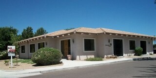
Property Record
10505 N 69Th St, Paradise Valley, AZ 85253


NEARBY LISTINGS FOR SALE OR LEASE
Property Detail
10505 N 69Th St
175-50-017A
PT S2 NE4 NW4 NE4 SEC 27 DAF COM SW COR NE4 NW4 NE4 SEC 27 SD COR ALSO BEING INTERSEC OF MON LNS OF 69TH ST & COCHISE RD TH N 140.16F TH E 30F TO PT ON E R/W LN 69TH ST & TPOB TH N ALG SD R/W LN 122F TH E 110F TH S 122F TH W 110F TPOB
Officebuilding
Maricopa
X
Arizona
04013C1760L
0.31 AC
2025
Central Scottsdale
2025
Phoenix
216830
Phoenix-Mesa-Chandler, AZ
7,300 SF
DEMOGRAPHICS near 10505 N 69Th St
1 Mile
3 Mile
5 Mile
2024 Total Population
7,597
60,567
201,162
2029 Population
8,261
66,359
220,294
Pop Growth 2024-2029
+ 8.74%
+ 9.56%
+ 9.51%
Average Age
46
47
45
2024 Total Households
3,488
26,562
90,993
HH Growth 2024-2029
+ 8.86%
+ 9.86%
+ 9.84%
Median Household Inc
$90,039
$115,662
$103,511
Avg Household Size
2.10
2.20
2.20
2024 Avg HH Vehicles
2.00
2.00
2.00
Median Home Value
$839,861
$754,005
$656,603
Median Year Built
1985
1984
1986
Nearby Places
Map Layers
Map Styles
 Street
 Aerial
- Restaurants
- Banks
- Shops
- Fitness
- Groceries
PUBLIC TRANSPORTATION
AIRPORT
Phoenix Sky Harbor International
DRIVE
WALK
Distance
Phoenix Sky Harbor International
28 min
14.7 mi
Phoenix-Mesa Gateway
DRIVE
WALK
Distance
Phoenix-Mesa Gateway
50 min
35.1 mi
SALE & LEASE HISTORY
LISTING DATE
SALE/LEASE

Jun 11, 2020
For Lease
Nearby Properties
Address
Land Use
TOTAL SIZE
Lot Size
Zoning
Address
Land Use
TOTAL SIZE
Lot Size
Zoning
17.81 AC
Address
Land Use
TOTAL SIZE
Lot Size
Zoning
3.15 AC
I-P
Address
Land Use
TOTAL SIZE
Lot Size
Zoning
33,244 SF
5.93 AC
C-2
Address
Land Use
TOTAL SIZE
Lot Size
Zoning
500,010 SF
4.52 AC
PF
Address
Land Use
TOTAL SIZE
Lot Size
Zoning
4.67 AC
Address
Land Use
TOTAL SIZE
Lot Size
Zoning
367,367 SF
37.89 AC
R-43
Address
Land Use
TOTAL SIZE
Lot Size
Zoning
623,263 SF
27.34 AC
M-H
Address
Land Use
TOTAL SIZE
Lot Size
Zoning
428,891 SF
6.48 AC
PAD
Address
Land Use
TOTAL SIZE
Lot Size
Zoning
9,232 SF
4.07 AC
R-35
Address
Land Use
TOTAL SIZE
Lot Size
Zoning
355,757 SF
32.44 AC
C-R
Address
Land Use
TOTAL SIZE
Lot Size
Zoning
337,668 SF
8.14 AC
PAD
Address
Land Use
TOTAL SIZE
Lot Size
Zoning
734,506 SF
7.75 AC
C-T
Address
Land Use
TOTAL SIZE
Lot Size
Zoning
417,831 SF
2.68 AC
C-R
Address
Land Use
TOTAL SIZE
Lot Size
Zoning
22,630 SF
1.06 AC
SUPP
Address
Land Use
TOTAL SIZE
Lot Size
Zoning
515,127 SF
7.57 AC
C-T
Address
Land Use
TOTAL SIZE
Lot Size
Zoning
250,415 SF
21 AC
I-P
Address
Land Use
TOTAL SIZE
Lot Size
Zoning
Address
Land Use
TOTAL SIZE
Lot Size
Zoning
580,563 SF
9 AC
C-T
Address
Land Use
TOTAL SIZE
Lot Size
Zoning
163,075 SF
17.77 AC
C-R
Address
Land Use
TOTAL SIZE
Lot Size
Zoning
353,691 SF
16.18 AC
M-H
Address
Land Use
TOTAL SIZE
Lot Size
Zoning
166,962 SF
52.81 AC
Address
Land Use
TOTAL SIZE
Lot Size
Zoning
388,480 SF
18.69 AC
PAD
Address
Land Use
TOTAL SIZE
Lot Size
Zoning
345,713 SF
18.25 AC
M-H
Address
Land Use
TOTAL SIZE
Lot Size
Zoning
380,453 SF
17.27 AC
M-H
Address
Land Use
TOTAL SIZE
Lot Size
Zoning
138,984 SF
14.30 AC
C-C
Address
Land Use
TOTAL SIZE
Lot Size
Zoning
247,810 SF
29.27 AC
Address
Land Use
TOTAL SIZE
Lot Size
Zoning
120,666 SF
16.55 AC
R-35
Address
Land Use
TOTAL SIZE
Lot Size
Zoning
20,355 SF
38.96 AC
M-H
Address
Land Use
TOTAL SIZE
Lot Size
Zoning
110,408 SF
6.73 AC
C-C
Address
Land Use
TOTAL SIZE
Lot Size
Zoning
270,059 SF
10.61 AC
M-H
The World's #1 Commercial Real Estate Marketplace
Connect with us
© 2026 CoStar Group
The information above has been obtained from sources believed reliable. While we do not doubt its accuracy we have not verified it and make no guarantee, warranty or representation about it. It is your responsibility to independently confirm its accuracy and completeness. Any projections, opinions, assumptions, or estimates used are for example only and do not represent the current or future performance of the property. The value of this transaction to you depends on tax and other factors which should be evaluated by your tax, financial, and legal advisors. You and your advisors should conduct a careful, independent investigation of the property to determine to your satisfaction the suitability of the property for your needs.