Property Record
10506 W Aero Rd, Spokane, WA 99224

Save to a Folder
{{folder.Name}}
{{folder.ListingIds.length}} Properties
{{folder.ListingIds.length}} Property
Create a New Folder
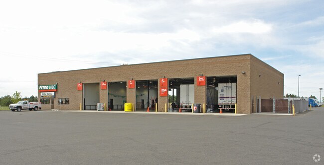
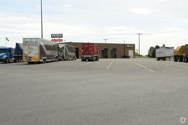
Property Detail
10506 W Aero Rd
24072.9068
07-24-42 PTN OF NW1/4 LYG NLY OF AERO RD WLY OF HAYFORD RD & ELY OF WESTBOW RD EXC PARCEL M (AFN# 9503170136) & EXC RDS.
Storebuilding
SPOKANE
RC
Washington
B and X Area of moderate flood hazard, usually the area between the limits of the 100-year and 500-year floods.
20.39 AC
2026
West Plains
2026
Spokane
014100
Spokane-Spokane Valley, WA
34,051 SF
NEARBY LISTINGS FOR SALE OR LEASE
-
-
View all Spokane listings for sale on LoopNet.com
DEMOGRAPHICS near 10506 W Aero Rd
1 mile
3 mile
5 mile
2025 Total Population
2,706
6,786
26,687
2030 Population
2,820
7,122
27,684
Pop Growth 2025-2030
+ 4.21%
+ 4.95%
+ 3.74%
Average Age
38
40
38
2025 Total Households
984
2,487
9,193
HH Growth 2025-2030
+ 4.27%
+ 4.99%
+ 3.89%
Median Household Inc
$98,306
$92,913
$73,142
Avg Household Size
2.70
2.70
2.60
2025 Avg HH Vehicles
2.00
2.00
2.00
Median Home Value
$426,065
$437,762
$423,625
Median Year Built
2005
2004
2004
Nearby Places
Map Layers
Map Styles
 Street
 Aerial
Layers
 Traffic
 Biking
Places
Listings with unknown addresses are not visible on the map
- Restaurants
- Banks
- Shops
- Fitness
- Groceries
PUBLIC TRANSPORTATION
COMMUTER RAIL
Drive
Walk
Distance
14 min
9.4 mi
AIRPORT
Spokane International
Drive
Walk
Distance
Spokane International
10 min
5.5 mi
Nearby Properties
Address
Land Use
TOTAL SIZE
Lot Size
Zoning
Address
Land Use
TOTAL SIZE
Lot Size
Zoning
2,689,133 SF
79.07 AC
LI
Address
Land Use
TOTAL SIZE
Lot Size
Zoning
771,910 SF
646.44 AC
Address
Land Use
TOTAL SIZE
Lot Size
Zoning
306,250 SF
16.11 AC
LI
Address
Land Use
TOTAL SIZE
Lot Size
Zoning
562,448 SF
62 AC
LI
Address
Land Use
TOTAL SIZE
Lot Size
Zoning
278,722 SF
44.44 AC
RC
Address
Land Use
TOTAL SIZE
Lot Size
Zoning
218,400 SF
14.69 AC
Address
Land Use
TOTAL SIZE
Lot Size
Zoning
187,000 SF
12.43 AC
I-2
Address
Land Use
TOTAL SIZE
Lot Size
Zoning
263,013 SF
10.12 AC
LI
Address
Land Use
TOTAL SIZE
Lot Size
Zoning
202,800 SF
13.77 AC
Address
Land Use
TOTAL SIZE
Lot Size
Zoning
147,774 SF
6.64 AC
RC
Address
Land Use
TOTAL SIZE
Lot Size
Zoning
78,801 SF
14.39 AC
RT
Address
Land Use
TOTAL SIZE
Lot Size
Zoning
141,000 SF
14.82 AC
Address
Land Use
TOTAL SIZE
Lot Size
Zoning
508,598 SF
28.78 AC
LI
Address
Land Use
TOTAL SIZE
Lot Size
Zoning
183,750 SF
21.40 AC
I-2
Address
Land Use
TOTAL SIZE
Lot Size
Zoning
155,440 SF
28.64 AC
LI
Address
Land Use
TOTAL SIZE
Lot Size
Zoning
152,130 SF
35.26 AC
I-2
Address
Land Use
TOTAL SIZE
Lot Size
Zoning
23,494 SF
8.32 AC
LI
Address
Land Use
TOTAL SIZE
Lot Size
Zoning
108,962 SF
14.58 AC
Address
Land Use
TOTAL SIZE
Lot Size
Zoning
91,482 SF
5.13 AC
MDR
Address
Land Use
TOTAL SIZE
Lot Size
Zoning
59,890 SF
9.94 AC
LI
Address
Land Use
TOTAL SIZE
Lot Size
Zoning
96,000 SF
6.72 AC
LI
Address
Land Use
TOTAL SIZE
Lot Size
Zoning
82,446 SF
3.55 AC
RC
Address
Land Use
TOTAL SIZE
Lot Size
Zoning
84,183 SF
11.07 AC
LI
Address
Land Use
TOTAL SIZE
Lot Size
Zoning
70,924 SF
22.62 AC
LI
Address
Land Use
TOTAL SIZE
Lot Size
Zoning
2,136,347 SF
228.86 AC
RT
Address
Land Use
TOTAL SIZE
Lot Size
Zoning
87,100 SF
4.95 AC
Address
Land Use
TOTAL SIZE
Lot Size
Zoning
64,267 SF
23.10 AC
LI
Address
Land Use
TOTAL SIZE
Lot Size
Zoning
75,000 SF
5.71 AC
LI
Address
Land Use
TOTAL SIZE
Lot Size
Zoning
57,384 SF
2.73 AC
LI
The World's #1 Commercial Real Estate Marketplace
Connect with us
© 2026 CoStar Group
The information above has been obtained from sources believed reliable. While we do not doubt its accuracy we have not verified it and make no guarantee, warranty or representation about it. It is your responsibility to independently confirm its accuracy and completeness. Any projections, opinions, assumptions, or estimates used are for example only and do not represent the current or future performance of the property. The value of this transaction to you depends on tax and other factors which should be evaluated by your tax, financial, and legal advisors. You and your advisors should conduct a careful, independent investigation of the property to determine to your satisfaction the suitability of the property for your needs.