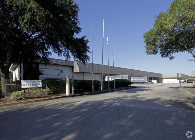
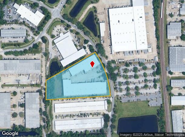
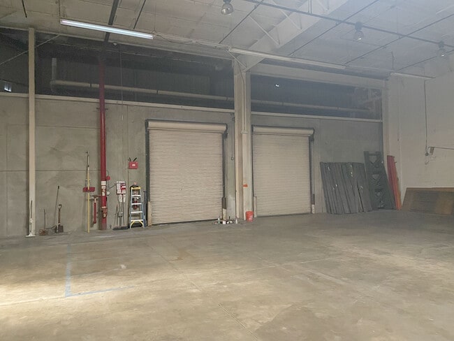
Property Record
1051 Bennett Dr, Longwood, FL 32750

Current Lease Availabilities
NEARBY LISTINGS FOR SALE OR LEASE
Property Detail
1051 Bennett Dr
Orlando-Kissimmee-Sanford, FL
Florida Central Commerce Park
06-21-30-510-0000-0350
LOT 35 FLORIDA CENTRAL COMMERCE PARK PB 27 PGS 53 TO 58
Stripcommercialcenter
Seminole
A
Florida
12117C0155F
35
2024
5.83 AC
2024
Seminole County
021504
Orlando
61,125 SF
DEMOGRAPHICS near 1051 Bennett Dr
1 Mile
3 Mile
5 Mile
2024 Total Population
5,421
83,803
217,030
2029 Population
5,840
87,414
225,732
Pop Growth 2024-2029
+ 7.73%
+ 4.31%
+ 4.01%
Average Age
46
42
42
2024 Total Households
1,992
35,071
89,761
HH Growth 2024-2029
+ 8.03%
+ 4.49%
+ 4.18%
Median Household Inc
$64,444
$61,357
$66,009
Avg Household Size
2.50
2.30
2.40
2024 Avg HH Vehicles
2.00
2.00
2.00
Median Home Value
$322,241
$278,975
$310,741
Median Year Built
1983
1979
1982
Nearby Places
- Restaurants
- Banks
- Shops
- Fitness
- Groceries
PUBLIC TRANSPORTATION
COMMUTER RAIL
Longwood (SunRail - Florida Department of Transportation)
DRIVE
WALK
Distance
Longwood (SunRail - Florida Department of Transportation)
4 min
1.7 mi
Altamonte Springs (SunRail - Florida Department of Transportation)
DRIVE
WALK
Distance
Altamonte Springs (SunRail - Florida Department of Transportation)
6 min
2.7 mi
AIRPORT
Orlando Sanford International
DRIVE
WALK
Distance
Orlando Sanford International
21 min
11.4 mi
Orlando International
DRIVE
WALK
Distance
Orlando International
35 min
19.4 mi
Freight Ports
Port Canaveral
DRIVE
WALK
Distance
Port Canaveral
80 min
61.6 mi
Nearby Properties
Address
Land Use
TOTAL SIZE
Lot Size
Zoning
Address
Land Use
TOTAL SIZE
Lot Size
Zoning
88,256 SF
39.64 AC
MOC3
Address
Land Use
TOTAL SIZE
Lot Size
Zoning
423,270 SF
3.45 AC
MOC3
Address
Land Use
TOTAL SIZE
Lot Size
Zoning
21.25 AC
GC
Address
Land Use
TOTAL SIZE
Lot Size
Zoning
Address
Land Use
TOTAL SIZE
Lot Size
Zoning
1,158 SF
17.22 AC
Address
Land Use
TOTAL SIZE
Lot Size
Zoning
629,182 SF
1.81 AC
R1A
Address
Land Use
TOTAL SIZE
Lot Size
Zoning
206 SF
1.43 AC
VMU
Address
Land Use
TOTAL SIZE
Lot Size
Zoning
400 SF
13.82 AC
R1AA
Address
Land Use
TOTAL SIZE
Lot Size
Zoning
5,256 SF
1.10 AC
PUDRES
Address
Land Use
TOTAL SIZE
Lot Size
Zoning
231,070 SF
35.59 AC
MOR2
Address
Land Use
TOTAL SIZE
Lot Size
Zoning
350,767 SF
11.12 AC
PUD
Address
Land Use
TOTAL SIZE
Lot Size
Zoning
456 SF
9.56 AC
Address
Land Use
TOTAL SIZE
Lot Size
Zoning
1,428 SF
8.56 AC
MOR3
Address
Land Use
TOTAL SIZE
Lot Size
Zoning
97,888 SF
3.72 AC
IND
Address
Land Use
TOTAL SIZE
Lot Size
Zoning
6,817 SF
19.83 AC
R3
Address
Land Use
TOTAL SIZE
Lot Size
Zoning
17,728 SF
14.64 AC
GC
Address
Land Use
TOTAL SIZE
Lot Size
Zoning
254,371 SF
15.63 AC
R1A
Address
Land Use
TOTAL SIZE
Lot Size
Zoning
6,466 SF
18.97 AC
MOC3
Address
Land Use
TOTAL SIZE
Lot Size
Zoning
279,457 SF
20.56 AC
R3
Address
Land Use
TOTAL SIZE
Lot Size
Zoning
377,321 SF
20.58 AC
R3A
Address
Land Use
TOTAL SIZE
Lot Size
Zoning
259,436 SF
11.23 AC
A1
Address
Land Use
TOTAL SIZE
Lot Size
Zoning
147,310 SF
16.71 AC
GC
Address
Land Use
TOTAL SIZE
Lot Size
Zoning
2,062 SF
7.30 AC
MOR2
Address
Land Use
TOTAL SIZE
Lot Size
Zoning
365,430 SF
2.70 AC
RMF13
Address
Land Use
TOTAL SIZE
Lot Size
Zoning
274,020 SF
19.35 AC
R3
Address
Land Use
TOTAL SIZE
Lot Size
Zoning
204 SF
30 AC
R3
Address
Land Use
TOTAL SIZE
Lot Size
Zoning
223,895 SF
13.16 AC
R3
Address
Land Use
TOTAL SIZE
Lot Size
Zoning
3,486 SF
13.28 AC
R3
Address
Land Use
TOTAL SIZE
Lot Size
Zoning
390,293 SF
47.33 AC
PI
Address
Land Use
TOTAL SIZE
Lot Size
Zoning
1,518 SF
12.08 AC
PUD
The World's #1 Commercial Real Estate Marketplace
Connect with us
© 2025 CoStar Group
The information above has been obtained from sources believed reliable. While we do not doubt its accuracy we have not verified it and make no guarantee, warranty or representation about it. It is your responsibility to independently confirm its accuracy and completeness. Any projections, opinions, assumptions, or estimates used are for example only and do not represent the current or future performance of the property. The value of this transaction to you depends on tax and other factors which should be evaluated by your tax, financial, and legal advisors. You and your advisors should conduct a careful, independent investigation of the property to determine to your satisfaction the suitability of the property for your needs.