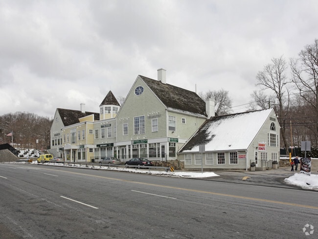
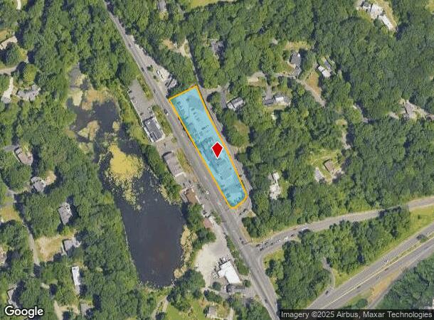
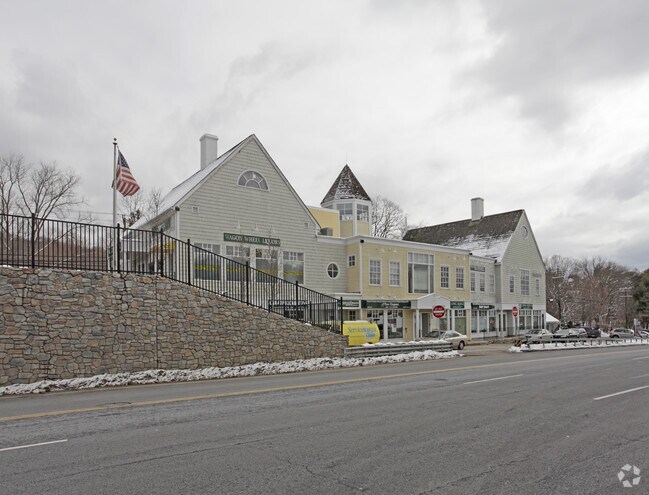
Property Record
1051 Long Ridge Rd, Stamford, CT 06903
NEARBY LISTINGS FOR SALE OR LEASE
Property Detail
1051 Long Ridge Rd
Commercialbuilding
Fairfield
X
Connecticut
09001C0502F
1.27 AC
2025
Stamford
2025
Westchester/So Connecticut
020400
Bridgeport-Stamford-Danbury, CT
16,430 SF
STAM-000001-000000-009154
DEMOGRAPHICS near 1051 Long Ridge Rd
1 Mile
3 Mile
5 Mile
2024 Total Population
5,066
47,804
182,182
2029 Population
5,074
47,976
183,444
Pop Growth 2024-2029
+ 0.16%
+ 0.36%
+ 0.69%
Average Age
44
42
39
2024 Total Households
1,779
17,342
69,315
HH Growth 2024-2029
+ 0.06%
+ 0.32%
+ 0.89%
Median Household Inc
$165,108
$152,300
$117,757
Avg Household Size
2.70
2.70
2.50
2024 Avg HH Vehicles
2.00
2.00
2.00
Median Home Value
$782,297
$717,565
$773,062
Median Year Built
1962
1963
1970
Nearby Places
Map Layers
Map Styles
 Street
 Aerial
- Restaurants
- Banks
- Shops
- Fitness
- Groceries
PUBLIC TRANSPORTATION
COMMUTER RAIL
Talmadge Hill Station (New Haven Line - Metro-North Commuter Railroad Company (Metro-North))
DRIVE
WALK
Distance
Talmadge Hill Station (New Haven Line - Metro-North Commuter Railroad Company (Metro-North))
7 min
4.3 mi
Springdale Station (New Haven Line - Metro-North Commuter Railroad Company (Metro-North))
DRIVE
WALK
Distance
Springdale Station (New Haven Line - Metro-North Commuter Railroad Company (Metro-North))
10 min
4.6 mi
AIRPORT
Westchester County
DRIVE
WALK
Distance
Westchester County
23 min
13.4 mi
LaGuardia
DRIVE
WALK
Distance
LaGuardia
57 min
36.2 mi
Freight Ports
Port of New Haven
DRIVE
WALK
Distance
Port of New Haven
59 min
41.6 mi
SALE & LEASE HISTORY
LISTING DATE
SALE/LEASE

Jul 26, 2023
For Lease
Apr 04, 2022
For Lease
Nearby Properties
Address
Land Use
TOTAL SIZE
Lot Size
Zoning
Address
Land Use
TOTAL SIZE
Lot Size
Zoning
13.21 AC
CSCD
Address
Land Use
TOTAL SIZE
Lot Size
Zoning
98,106 SF
42.71 AC
RA-2
Address
Land Use
TOTAL SIZE
Lot Size
Zoning
32.43 AC
RA1
Address
Land Use
TOTAL SIZE
Lot Size
Zoning
25.91 AC
MZN
Address
Land Use
TOTAL SIZE
Lot Size
Zoning
29.87 AC
R10
Address
Land Use
TOTAL SIZE
Lot Size
Zoning
76.36 AC
2AC
Address
Land Use
TOTAL SIZE
Lot Size
Zoning
26.11 AC
CN
Address
Land Use
TOTAL SIZE
Lot Size
Zoning
75,531 SF
6.85 AC
MZN
Address
Land Use
TOTAL SIZE
Lot Size
Zoning
277,836 SF
2.17 AC
CB
Address
Land Use
TOTAL SIZE
Lot Size
Zoning
34.05 AC
RA1
Address
Land Use
TOTAL SIZE
Lot Size
Zoning
16.99 AC
CD
Address
Land Use
TOTAL SIZE
Lot Size
Zoning
28.54 AC
R20
Address
Land Use
TOTAL SIZE
Lot Size
Zoning
23.84 AC
CD
Address
Land Use
TOTAL SIZE
Lot Size
Zoning
219,634 SF
10 AC
CD
Address
Land Use
TOTAL SIZE
Lot Size
Zoning
7.84 AC
BD
Address
Land Use
TOTAL SIZE
Lot Size
Zoning
196,860 SF
CN
Address
Land Use
TOTAL SIZE
Lot Size
Zoning
40.46 AC
RA2
Address
Land Use
TOTAL SIZE
Lot Size
Zoning
3,705 SF
158.41 AC
RA-2
Address
Land Use
TOTAL SIZE
Lot Size
Zoning
160,203 SF
12.38 AC
MZN
Address
Land Use
TOTAL SIZE
Lot Size
Zoning
16.96 AC
R20
Address
Land Use
TOTAL SIZE
Lot Size
Zoning
90,690 SF
12.80 AC
R20
Address
Land Use
TOTAL SIZE
Lot Size
Zoning
8.79 AC
R10
Address
Land Use
TOTAL SIZE
Lot Size
Zoning
36.58 AC
CD
Address
Land Use
TOTAL SIZE
Lot Size
Zoning
14.07 AC
CD
Address
Land Use
TOTAL SIZE
Lot Size
Zoning
3.50 AC
CN
Address
Land Use
TOTAL SIZE
Lot Size
Zoning
12.22 AC
RA1
Address
Land Use
TOTAL SIZE
Lot Size
Zoning
15 AC
CD
Address
Land Use
TOTAL SIZE
Lot Size
Zoning
8,337 SF
132.50 AC
P
Address
Land Use
TOTAL SIZE
Lot Size
Zoning
12.82 AC
RA1
Address
Land Use
TOTAL SIZE
Lot Size
Zoning
87,525 SF
16.87 AC
RA1
The World's #1 Commercial Real Estate Marketplace
Connect with us
© 2026 CoStar Group
The information above has been obtained from sources believed reliable. While we do not doubt its accuracy we have not verified it and make no guarantee, warranty or representation about it. It is your responsibility to independently confirm its accuracy and completeness. Any projections, opinions, assumptions, or estimates used are for example only and do not represent the current or future performance of the property. The value of this transaction to you depends on tax and other factors which should be evaluated by your tax, financial, and legal advisors. You and your advisors should conduct a careful, independent investigation of the property to determine to your satisfaction the suitability of the property for your needs.