Property Record
1051 Peterson Dr, Decatur, AR 72722

NEARBY LISTINGS FOR SALE OR LEASE
-
-
View all Decatur listings for sale on LoopNet.com
Property Detail
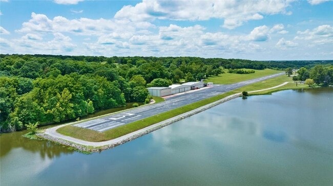
1051 Peterson Dr
08-00082-516
Decatur
Aircraft
TRACTS 1 AND 2: PART OF THE SE 1/4 OF THE SW 1/4 OF SECTION 01 AND PART OF THE NW 1/4 OF THE NW 1/4 AND PART OF THE NE 1/4 OF THE NW 1/4, AND PUT OF THE NW 114 OF THE NE 114 AND PART OF THE NE 1/4 OF THE NE 1/4, ALL OF THE SE 1/4 OF THE NW 1/4, ALL O
AE
Benton
05007C0205J
Arkansas
2025
40.57 AC
2025
Outlying Benton County
020906
Fayetteville/Springdale/Rogers
5,586 SF
Fayetteville-Springdale-Rogers, AR-MO
DEMOGRAPHICS near 1051 Peterson Dr
1 Mile
3 Mile
5 Mile
2024 Total Population
641
2,716
5,645
2029 Population
742
3,169
6,625
Pop Growth 2024-2029
+ 15.76%
+ 16.68%
+ 17.36%
Average Age
39
38
38
2024 Total Households
233
958
2,008
HH Growth 2024-2029
+ 15.88%
+ 16.70%
+ 17.43%
Median Household Inc
$69,374
$75,387
$67,943
Avg Household Size
2.70
2.80
2.80
2024 Avg HH Vehicles
2.00
2.00
2.00
Median Home Value
$189,436
$192,499
$198,104
Median Year Built
1988
1987
1991
Nearby Places
Map Layers
Map Styles
 Street
 Aerial
- Restaurants
- Banks
- Shops
- Fitness
- Groceries
PUBLIC TRANSPORTATION
AIRPORT
Northwest Arkansas Ntl
DRIVE
WALK
Distance
Northwest Arkansas Ntl
36 min
16.0 mi
Freight Ports
Tulsa Port of Inola
DRIVE
WALK
Distance
Tulsa Port of Inola
96 min
79.1 mi
SALE & LEASE HISTORY
LISTING DATE
SALE/LEASE

Sep 05, 2024
For Sale
Jul 21, 2023
For Sale
Nearby Properties
Address
Land Use
TOTAL SIZE
Lot Size
Zoning
Address
Land Use
TOTAL SIZE
Lot Size
Zoning
58,602 SF
41.78 AC
Address
Land Use
TOTAL SIZE
Lot Size
Zoning
1,260 SF
1.16 AC
Address
Land Use
TOTAL SIZE
Lot Size
Zoning
11,161 SF
111.82 AC
Address
Land Use
TOTAL SIZE
Lot Size
Zoning
69,480 SF
4.17 AC
Address
Land Use
TOTAL SIZE
Lot Size
Zoning
46,164 SF
1.70 AC
Address
Land Use
TOTAL SIZE
Lot Size
Zoning
151,355 SF
13.52 AC
Address
Land Use
TOTAL SIZE
Lot Size
Zoning
40,024 SF
9 AC
Address
Land Use
TOTAL SIZE
Lot Size
Zoning
70,192 SF
2.44 AC
Address
Land Use
TOTAL SIZE
Lot Size
Zoning
34,200 SF
24.48 AC
Address
Land Use
TOTAL SIZE
Lot Size
Zoning
101,447 SF
10 AC
Address
Land Use
TOTAL SIZE
Lot Size
Zoning
31,299 SF
9.99 AC
Address
Land Use
TOTAL SIZE
Lot Size
Zoning
14,820 SF
6.68 AC
Address
Land Use
TOTAL SIZE
Lot Size
Zoning
8,095 SF
1.72 AC
Address
Land Use
TOTAL SIZE
Lot Size
Zoning
15,411 SF
3.10 AC
Address
Land Use
TOTAL SIZE
Lot Size
Zoning
25,592 SF
3.77 AC
Address
Land Use
TOTAL SIZE
Lot Size
Zoning
11,700 SF
0.28 AC
Address
Land Use
TOTAL SIZE
Lot Size
Zoning
20,794 SF
3 AC
Address
Land Use
TOTAL SIZE
Lot Size
Zoning
14,112 SF
3.31 AC
Address
Land Use
TOTAL SIZE
Lot Size
Zoning
13,544 SF
0.26 AC
Address
Land Use
TOTAL SIZE
Lot Size
Zoning
16,631 SF
6.61 AC
Address
Land Use
TOTAL SIZE
Lot Size
Zoning
73,379 SF
8.75 AC
Address
Land Use
TOTAL SIZE
Lot Size
Zoning
17,220 SF
1.67 AC
Address
Land Use
TOTAL SIZE
Lot Size
Zoning
32,076 SF
1.67 AC
Address
Land Use
TOTAL SIZE
Lot Size
Zoning
17,320 SF
1.61 AC
Address
Land Use
TOTAL SIZE
Lot Size
Zoning
6,626 SF
0.62 AC
Address
Land Use
TOTAL SIZE
Lot Size
Zoning
9,866 SF
1.14 AC
Address
Land Use
TOTAL SIZE
Lot Size
Zoning
15,908 SF
9.99 AC
Address
Land Use
TOTAL SIZE
Lot Size
Zoning
26,460 SF
8.66 AC
Address
Land Use
TOTAL SIZE
Lot Size
Zoning
6,268 SF
3.10 AC
The World's #1 Commercial Real Estate Marketplace
Connect with us
© 2025 CoStar Group
The information above has been obtained from sources believed reliable. While we do not doubt its accuracy we have not verified it and make no guarantee, warranty or representation about it. It is your responsibility to independently confirm its accuracy and completeness. Any projections, opinions, assumptions, or estimates used are for example only and do not represent the current or future performance of the property. The value of this transaction to you depends on tax and other factors which should be evaluated by your tax, financial, and legal advisors. You and your advisors should conduct a careful, independent investigation of the property to determine to your satisfaction the suitability of the property for your needs.