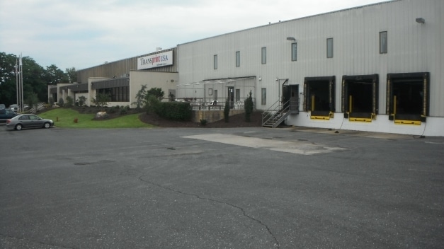
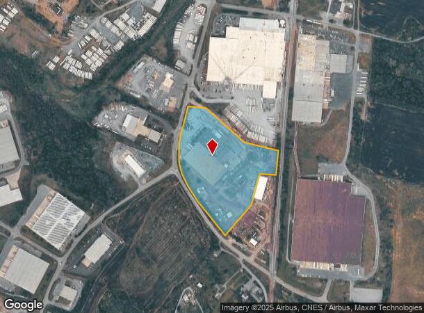
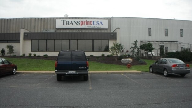
Property Record
1051 Pleasant Valley Rd, Rockingham, VA 22801
NEARBY LISTINGS FOR SALE OR LEASE
Property Detail
1051 Pleasant Valley Rd
Commercialnec
Rockingham
X
Virginia
51165C0394D
13.14 AC
2025
Staunton & Harrisonburg
2025
Other Market Areas
011700
Harrisonburg, VA
107,264 SF
124F-A-L71
DEMOGRAPHICS near 1051 Pleasant Valley Rd
1 Mile
3 Mile
5 Mile
2024 Total Population
578
21,266
68,623
2029 Population
596
21,668
69,298
Pop Growth 2024-2029
+ 3.11%
+ 1.89%
+ 0.98%
Average Age
36
34
35
2024 Total Households
227
7,855
23,400
HH Growth 2024-2029
+ 3.52%
+ 1.99%
+ 1.15%
Median Household Inc
$77,273
$63,275
$64,574
Avg Household Size
2.50
2.50
2.50
2024 Avg HH Vehicles
2.00
2.00
2.00
Median Home Value
$259,999
$277,632
$302,211
Median Year Built
2001
1998
1991
Nearby Places
Map Layers
Map Styles
 Street
 Aerial
- Restaurants
- Banks
- Shops
- Fitness
- Groceries
PUBLIC TRANSPORTATION
AIRPORT
Charlottesville-Albemarle
DRIVE
WALK
Distance
Charlottesville-Albemarle
72 min
48.6 mi
SALE & LEASE HISTORY
LISTING DATE
SALE/LEASE

Sep 23, 2016
For Sale
Mar 29, 2017
For Lease
Nearby Properties
Address
Land Use
TOTAL SIZE
Lot Size
Zoning
Address
Land Use
TOTAL SIZE
Lot Size
Zoning
122,976 SF
59.92 AC
Address
Land Use
TOTAL SIZE
Lot Size
Zoning
126,552 SF
49.87 AC
GENERAL BU
Address
Land Use
TOTAL SIZE
Lot Size
Zoning
57.92 AC
I1
Address
Land Use
TOTAL SIZE
Lot Size
Zoning
199.08 AC
I1
Address
Land Use
TOTAL SIZE
Lot Size
Zoning
36.81 AC
R5
Address
Land Use
TOTAL SIZE
Lot Size
Zoning
11.56 AC
B1
Address
Land Use
TOTAL SIZE
Lot Size
Zoning
225,359 SF
33.32 AC
I1
Address
Land Use
TOTAL SIZE
Lot Size
Zoning
14,490 SF
190 AC
PLANNED UN
Address
Land Use
TOTAL SIZE
Lot Size
Zoning
11.11 AC
R3
Address
Land Use
TOTAL SIZE
Lot Size
Zoning
6.10 AC
PMF
Address
Land Use
TOTAL SIZE
Lot Size
Zoning
295,543 SF
33.23 AC
I1
Address
Land Use
TOTAL SIZE
Lot Size
Zoning
9,440 SF
17.31 AC
R3
Address
Land Use
TOTAL SIZE
Lot Size
Zoning
905,215 SF
26.54 AC
M1
Address
Land Use
TOTAL SIZE
Lot Size
Zoning
15,432 SF
132 AC
MULTI DWEL
Address
Land Use
TOTAL SIZE
Lot Size
Zoning
13,578 SF
180 AC
HIGH DENSI
Address
Land Use
TOTAL SIZE
Lot Size
Zoning
15,432 SF
108 AC
MULTI DWEL
Address
Land Use
TOTAL SIZE
Lot Size
Zoning
25,020 SF
3.80 AC
COMMERCIAL
Address
Land Use
TOTAL SIZE
Lot Size
Zoning
13,986 SF
9.87 AC
R3
Address
Land Use
TOTAL SIZE
Lot Size
Zoning
15,244 SF
7.01 AC
R4
Address
Land Use
TOTAL SIZE
Lot Size
Zoning
84,000 SF
17 AC
GENERAL IN
Address
Land Use
TOTAL SIZE
Lot Size
Zoning
348,800 SF
26.90 AC
I1
Address
Land Use
TOTAL SIZE
Lot Size
Zoning
172,194 SF
4.24 AC
B1
Address
Land Use
TOTAL SIZE
Lot Size
Zoning
2,145 SF
2.71 AC
PMF
Address
Land Use
TOTAL SIZE
Lot Size
Zoning
13,440 SF
96 AC
PLANNED UN
Address
Land Use
TOTAL SIZE
Lot Size
Zoning
21.42 AC
I1
Address
Land Use
TOTAL SIZE
Lot Size
Zoning
4.82 AC
B1
Address
Land Use
TOTAL SIZE
Lot Size
Zoning
3,876 SF
8.86 AC
R3
Address
Land Use
TOTAL SIZE
Lot Size
Zoning
73,000 SF
22.26 AC
SINGLE FAM
Address
Land Use
TOTAL SIZE
Lot Size
Zoning
34,466 SF
16.29 AC
A2
Address
Land Use
TOTAL SIZE
Lot Size
Zoning
15.50 AC
GENERAL IN
The World's #1 Commercial Real Estate Marketplace
Connect with us
© 2026 CoStar Group
The information above has been obtained from sources believed reliable. While we do not doubt its accuracy we have not verified it and make no guarantee, warranty or representation about it. It is your responsibility to independently confirm its accuracy and completeness. Any projections, opinions, assumptions, or estimates used are for example only and do not represent the current or future performance of the property. The value of this transaction to you depends on tax and other factors which should be evaluated by your tax, financial, and legal advisors. You and your advisors should conduct a careful, independent investigation of the property to determine to your satisfaction the suitability of the property for your needs.