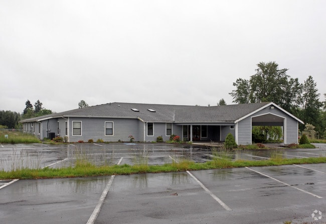
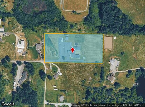
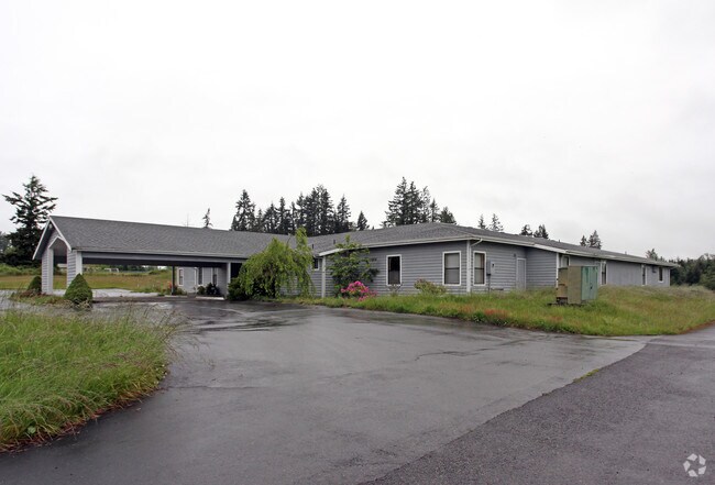
Property Record
10515 269Th St E, Graham, WA 98338

NEARBY LISTINGS FOR SALE OR LEASE
Property Detail
10515 269Th St E
041827-3031
SECTION 27 TOWNSHIP 18 RANGE 04 QUARTER 33 : N 1/2 OF NE OF SW OF SW EASE OF RECORD COMB TO RESTORE PARCEL SEGD FOR TAX PURPOSES ONLY COMB OF 3-023 & 3-024 SEG R-0237 JU
Religious
Pierce
X
Washington
53053C0593E
5 AC
2024
E Pierce County
2025
Seattle/Puget Sound
073119
Seattle-Tacoma-Bellevue, WA
8,304 SF
DEMOGRAPHICS near 10515 269Th St E
1 Mile
3 Mile
5 Mile
2024 Total Population
996
10,728
49,210
2029 Population
1,017
10,910
50,141
Pop Growth 2024-2029
+ 2.11%
+ 1.70%
+ 1.89%
Average Age
42
40
39
2024 Total Households
352
3,639
16,440
HH Growth 2024-2029
+ 1.99%
+ 1.73%
+ 1.89%
Median Household Inc
$83,098
$95,700
$98,753
Avg Household Size
2.80
2.90
2.90
2024 Avg HH Vehicles
3.00
3.00
3.00
Median Home Value
$572,443
$529,144
$455,960
Median Year Built
1992
1993
1994
Nearby Places
Map Layers
Map Styles
 Street
 Aerial
- Restaurants
- Banks
- Shops
- Fitness
- Groceries
PUBLIC TRANSPORTATION
AIRPORT
Seattle-Tacoma International
DRIVE
WALK
Distance
Seattle-Tacoma International
59 min
35.6 mi
Freight Ports
Port of Tacoma
DRIVE
WALK
Distance
Port of Tacoma
40 min
21.0 mi
Nearby Properties
Address
Land Use
TOTAL SIZE
Lot Size
Zoning
Address
Land Use
TOTAL SIZE
Lot Size
Zoning
82,882 SF
20.87 AC
R10
Address
Land Use
TOTAL SIZE
Lot Size
Zoning
47,442 SF
19.03 AC
R10
Address
Land Use
TOTAL SIZE
Lot Size
Zoning
51,088 SF
10.26 AC
R10
Address
Land Use
TOTAL SIZE
Lot Size
Zoning
42,946 SF
9.55 AC
R10
Address
Land Use
TOTAL SIZE
Lot Size
Zoning
44,626 SF
3.60 AC
RAC
Address
Land Use
TOTAL SIZE
Lot Size
Zoning
25,335 SF
5.34 AC
RAC
Address
Land Use
TOTAL SIZE
Lot Size
Zoning
28,183 SF
2.48 AC
RAC
Address
Land Use
TOTAL SIZE
Lot Size
Zoning
42,672 SF
7.87 AC
RSR
Address
Land Use
TOTAL SIZE
Lot Size
Zoning
17,608 SF
5 AC
R10
Address
Land Use
TOTAL SIZE
Lot Size
Zoning
25,033 SF
4.70 AC
R10
Address
Land Use
TOTAL SIZE
Lot Size
Zoning
1 SF
17.22 AC
RSR
Address
Land Use
TOTAL SIZE
Lot Size
Zoning
14,538 SF
1.54 AC
RAC
Address
Land Use
TOTAL SIZE
Lot Size
Zoning
14,334 SF
2.06 AC
RAC
Address
Land Use
TOTAL SIZE
Lot Size
Zoning
1 SF
79.65 AC
RSR
Address
Land Use
TOTAL SIZE
Lot Size
Zoning
17,387 SF
1.69 AC
R10
Address
Land Use
TOTAL SIZE
Lot Size
Zoning
12,376 SF
1.10 AC
RAC
Address
Land Use
TOTAL SIZE
Lot Size
Zoning
3,234 SF
113.68 AC
ARL
Address
Land Use
TOTAL SIZE
Lot Size
Zoning
10,042 SF
4.44 AC
R10
Address
Land Use
TOTAL SIZE
Lot Size
Zoning
20,928 SF
3.50 AC
R10
Address
Land Use
TOTAL SIZE
Lot Size
Zoning
2,892 SF
3.97 AC
RAC
Address
Land Use
TOTAL SIZE
Lot Size
Zoning
7,700 SF
0.90 AC
R10
Address
Land Use
TOTAL SIZE
Lot Size
Zoning
8,514 SF
3.04 AC
R10
Address
Land Use
TOTAL SIZE
Lot Size
Zoning
1 SF
22.65 AC
Address
Land Use
TOTAL SIZE
Lot Size
Zoning
9,100 SF
3.56 AC
R10
Address
Land Use
TOTAL SIZE
Lot Size
Zoning
9,913 SF
70.43 AC
Address
Land Use
TOTAL SIZE
Lot Size
Zoning
9,900 SF
10.22 AC
RSR
Address
Land Use
TOTAL SIZE
Lot Size
Zoning
2,599 SF
0.94 AC
RAC
Address
Land Use
TOTAL SIZE
Lot Size
Zoning
6,300 SF
0.74 AC
R10
Address
Land Use
TOTAL SIZE
Lot Size
Zoning
13,903 SF
67.03 AC
ARL
The World's #1 Commercial Real Estate Marketplace
Connect with us
© 2026 CoStar Group
The information above has been obtained from sources believed reliable. While we do not doubt its accuracy we have not verified it and make no guarantee, warranty or representation about it. It is your responsibility to independently confirm its accuracy and completeness. Any projections, opinions, assumptions, or estimates used are for example only and do not represent the current or future performance of the property. The value of this transaction to you depends on tax and other factors which should be evaluated by your tax, financial, and legal advisors. You and your advisors should conduct a careful, independent investigation of the property to determine to your satisfaction the suitability of the property for your needs.