Property Record
1052 N Us Highway 65, Carrollton, MO 64633
NEARBY LISTINGS FOR SALE OR LEASE
-
-
View all Carrollton listings for sale on LoopNet.com
Property Detail
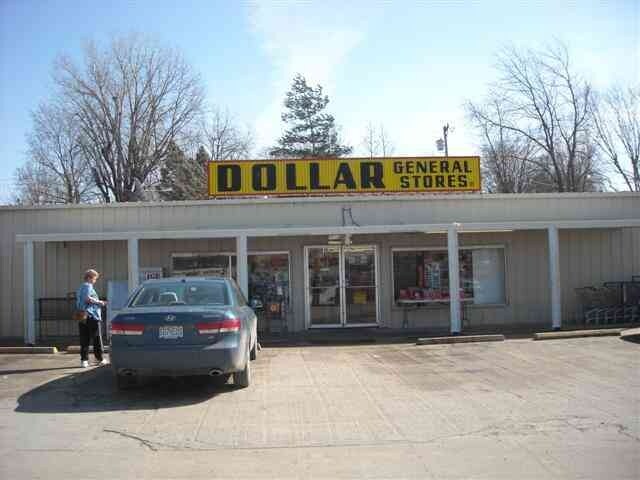
1052 N Us Highway 65
Storebuilding
TRCT DESCRIBED AS BEG; AT A POINT ON E R/W HWY 65 478' N OF S LINE SEC 28, TH E 218.7; TH N 288'; TH W 218.7'; TH S 282 TO PO
X
Carroll
29195C0075C
Missouri
2024
1.42 AC
2025
Missouri North Area
960300
Other Market Areas
9,301 SF
14-8.0-28-4-01-042
DEMOGRAPHICS near 1052 N Us Highway 65
1 Mile
3 Mile
5 Mile
2024 Total Population
2,474
4,309
4,623
2029 Population
2,468
4,313
4,611
Pop Growth 2024-2029
(0.24%)
+ 0.09%
(0.26%)
Average Age
43
43
43
2024 Total Households
1,034
1,820
1,951
HH Growth 2024-2029
(0.19%)
+ 0.16%
(0.21%)
Median Household Inc
$43,382
$54,242
$54,770
Avg Household Size
2.20
2.20
2.30
2024 Avg HH Vehicles
2.00
2.00
2.00
Median Home Value
$89,452
$89,644
$91,515
Median Year Built
1965
1964
1964
Nearby Places
Map Layers
Map Styles
 Street
 Aerial
- Restaurants
- Banks
- Shops
- Fitness
- Groceries
Nearby Properties
Address
Land Use
TOTAL SIZE
Lot Size
Zoning
Address
Land Use
TOTAL SIZE
Lot Size
Zoning
Address
Land Use
TOTAL SIZE
Lot Size
Zoning
2.85 AC
Address
Land Use
TOTAL SIZE
Lot Size
Zoning
18,050 SF
2.11 AC
Address
Land Use
TOTAL SIZE
Lot Size
Zoning
46.77 AC
Address
Land Use
TOTAL SIZE
Lot Size
Zoning
720 SF
4.63 AC
Address
Land Use
TOTAL SIZE
Lot Size
Zoning
12.32 AC
Address
Land Use
TOTAL SIZE
Lot Size
Zoning
0.65 AC
Address
Land Use
TOTAL SIZE
Lot Size
Zoning
2.54 AC
Address
Land Use
TOTAL SIZE
Lot Size
Zoning
26,820 SF
3.60 AC
Address
Land Use
TOTAL SIZE
Lot Size
Zoning
7,930 SF
0.94 AC
Address
Land Use
TOTAL SIZE
Lot Size
Zoning
Address
Land Use
TOTAL SIZE
Lot Size
Zoning
3.10 AC
Address
Land Use
TOTAL SIZE
Lot Size
Zoning
Address
Land Use
TOTAL SIZE
Lot Size
Zoning
5.18 AC
Address
Land Use
TOTAL SIZE
Lot Size
Zoning
3,309 SF
0.40 AC
Address
Land Use
TOTAL SIZE
Lot Size
Zoning
2,501 SF
0.57 AC
Address
Land Use
TOTAL SIZE
Lot Size
Zoning
22.90 AC
Address
Land Use
TOTAL SIZE
Lot Size
Zoning
0.28 AC
Address
Land Use
TOTAL SIZE
Lot Size
Zoning
4,300 SF
1.76 AC
Address
Land Use
TOTAL SIZE
Lot Size
Zoning
65.90 AC
Address
Land Use
TOTAL SIZE
Lot Size
Zoning
0.46 AC
Address
Land Use
TOTAL SIZE
Lot Size
Zoning
6.30 AC
Address
Land Use
TOTAL SIZE
Lot Size
Zoning
9.60 AC
Address
Land Use
TOTAL SIZE
Lot Size
Zoning
80 AC
Address
Land Use
TOTAL SIZE
Lot Size
Zoning
0.86 AC
The World's #1 Commercial Real Estate Marketplace
Connect with us
© 2025 CoStar Group
The information above has been obtained from sources believed reliable. While we do not doubt its accuracy we have not verified it and make no guarantee, warranty or representation about it. It is your responsibility to independently confirm its accuracy and completeness. Any projections, opinions, assumptions, or estimates used are for example only and do not represent the current or future performance of the property. The value of this transaction to you depends on tax and other factors which should be evaluated by your tax, financial, and legal advisors. You and your advisors should conduct a careful, independent investigation of the property to determine to your satisfaction the suitability of the property for your needs.