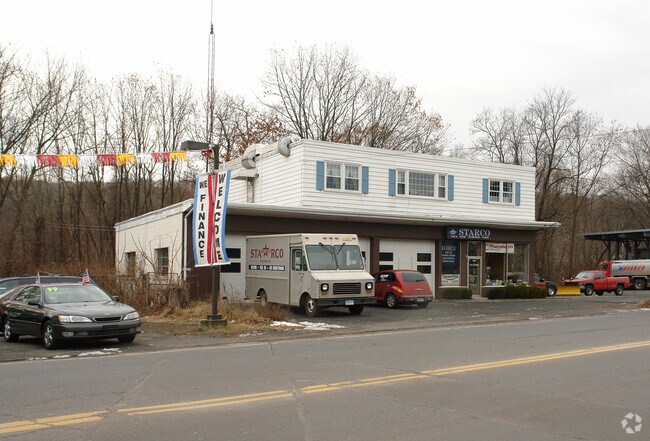
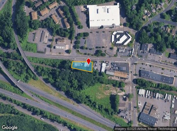
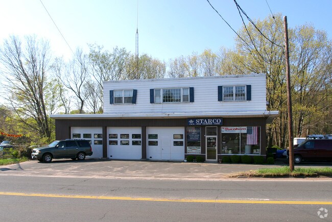
Property Record
1052 W Main St, New Britain, CT 06053
NEARBY LISTINGS FOR SALE OR LEASE
Property Detail
1052 W Main St
Commercialbuilding
Hartford
X
Connecticut
09003C0487G
0.35 AC
2025
New Britain
2025
Hartford
416500
Hartford-West Hartford-East Hartford, CT
4,130 SF
NBRI-000004A-000000-F000031
DEMOGRAPHICS near 1052 W Main St
1 Mile
3 Mile
5 Mile
2024 Total Population
7,427
75,877
154,979
2029 Population
7,344
75,195
153,965
Pop Growth 2024-2029
(1.12%)
(0.90%)
(0.65%)
Average Age
40
39
41
2024 Total Households
2,876
31,033
63,188
HH Growth 2024-2029
(1.18%)
(0.88%)
(0.65%)
Median Household Inc
$66,674
$55,265
$67,849
Avg Household Size
2.50
2.30
2.30
2024 Avg HH Vehicles
2.00
2.00
2.00
Median Home Value
$178,897
$201,705
$242,294
Median Year Built
1954
1955
1963
Nearby Places
Map Layers
Map Styles
 Street
 Aerial
- Restaurants
- Banks
- Shops
- Fitness
- Groceries
PUBLIC TRANSPORTATION
COMMUTER RAIL
DRIVE
WALK
Distance
8 min
4.3 mi
DRIVE
WALK
Distance
8 min
4.3 mi
AIRPORT
Bradley International
DRIVE
WALK
Distance
Bradley International
43 min
27.6 mi
Tweed/New Haven
DRIVE
WALK
Distance
Tweed/New Haven
50 min
33.0 mi
Freight Ports
Port of New Haven
DRIVE
WALK
Distance
Port of New Haven
45 min
30.4 mi
Nearby Properties
Address
Land Use
TOTAL SIZE
Lot Size
Zoning
Address
Land Use
TOTAL SIZE
Lot Size
Zoning
146,740 SF
18.23 AC
TPC
Address
Land Use
TOTAL SIZE
Lot Size
Zoning
23.64 AC
S3
Address
Land Use
TOTAL SIZE
Lot Size
Zoning
131.09 AC
OP
Address
Land Use
TOTAL SIZE
Lot Size
Zoning
19.60 AC
S2
Address
Land Use
TOTAL SIZE
Lot Size
Zoning
134,488 SF
63.26 AC
GC
Address
Land Use
TOTAL SIZE
Lot Size
Zoning
138.27 AC
S1
Address
Land Use
TOTAL SIZE
Lot Size
Zoning
64,822 SF
9.47 AC
TP
Address
Land Use
TOTAL SIZE
Lot Size
Zoning
155,161 SF
18.18 AC
S1
Address
Land Use
TOTAL SIZE
Lot Size
Zoning
2.07 AC
CBD
Address
Land Use
TOTAL SIZE
Lot Size
Zoning
117,139 SF
6.77 AC
T
Address
Land Use
TOTAL SIZE
Lot Size
Zoning
90,625 SF
0.97 AC
CBD
Address
Land Use
TOTAL SIZE
Lot Size
Zoning
96,238 SF
6.75 AC
T
Address
Land Use
TOTAL SIZE
Lot Size
Zoning
2.46 AC
CBD
Address
Land Use
TOTAL SIZE
Lot Size
Zoning
33.36 AC
T
Address
Land Use
TOTAL SIZE
Lot Size
Zoning
112,304 SF
10.39 AC
S3
Address
Land Use
TOTAL SIZE
Lot Size
Zoning
14,364 SF
2.72 AC
S3
Address
Land Use
TOTAL SIZE
Lot Size
Zoning
89,544 SF
6.20 AC
S1
Address
Land Use
TOTAL SIZE
Lot Size
Zoning
28.47 AC
R-10
Address
Land Use
TOTAL SIZE
Lot Size
Zoning
288,827 SF
24.01 AC
RI
Address
Land Use
TOTAL SIZE
Lot Size
Zoning
74,670 SF
4.46 AC
S2
Address
Land Use
TOTAL SIZE
Lot Size
Zoning
78,132 SF
11.76 AC
S2
Address
Land Use
TOTAL SIZE
Lot Size
Zoning
10.10 AC
RDM
Address
Land Use
TOTAL SIZE
Lot Size
Zoning
183,626 SF
12.72 AC
UI
Address
Land Use
TOTAL SIZE
Lot Size
Zoning
4.43 AC
B3/A2
Address
Land Use
TOTAL SIZE
Lot Size
Zoning
69,025 SF
10.90 AC
S2
Address
Land Use
TOTAL SIZE
Lot Size
Zoning
76,510 SF
10 AC
R-11
Address
Land Use
TOTAL SIZE
Lot Size
Zoning
2 AC
OP
Address
Land Use
TOTAL SIZE
Lot Size
Zoning
12.53 AC
CBD
Address
Land Use
TOTAL SIZE
Lot Size
Zoning
13.37 AC
B2
Address
Land Use
TOTAL SIZE
Lot Size
Zoning
4.10 AC
S3
The World's #1 Commercial Real Estate Marketplace
Connect with us
© 2025 CoStar Group
The information above has been obtained from sources believed reliable. While we do not doubt its accuracy we have not verified it and make no guarantee, warranty or representation about it. It is your responsibility to independently confirm its accuracy and completeness. Any projections, opinions, assumptions, or estimates used are for example only and do not represent the current or future performance of the property. The value of this transaction to you depends on tax and other factors which should be evaluated by your tax, financial, and legal advisors. You and your advisors should conduct a careful, independent investigation of the property to determine to your satisfaction the suitability of the property for your needs.