Property Record
10521 579 Hwy, Thonotosassa, FL 33592
This Property Is For Sale
NEARBY LISTINGS FOR SALE OR LEASE
Property Detail
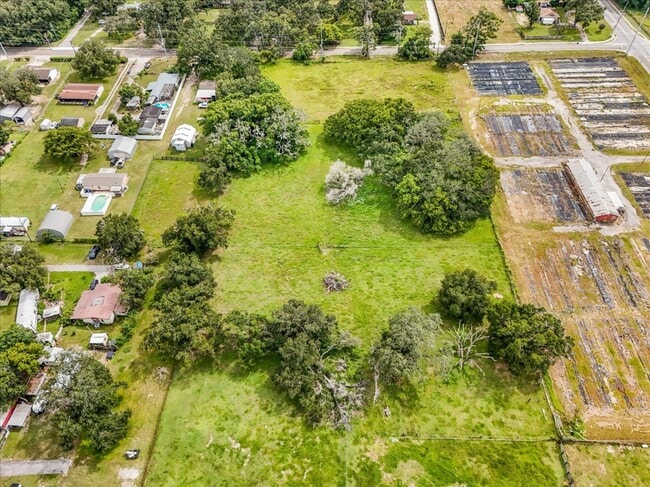
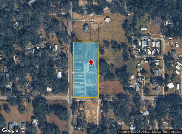
10521 579 Hwy
Tampa-St. Petersburg-Clearwater, FL
Unplatted
U-15-28-20-ZZZ-000002-04530.0
W 1/2 OF SW 1/4 OF NW 1/4 OF NW 1/4 LESS W 30 FT FOR RD
Warehouse
Hillsborough
X
Florida
12057C0245H
4530
2024
4.36 AC
2024
Northeast Tampa
010303
Tampa/St Petersburg
4,004 SF
DEMOGRAPHICS near 10521 579 Hwy
1 Mile
3 Mile
5 Mile
2024 Total Population
3,992
14,853
70,764
2029 Population
4,299
16,309
77,424
Pop Growth 2024-2029
+ 7.69%
+ 9.80%
+ 9.41%
Average Age
40
41
39
2024 Total Households
1,492
5,440
26,757
HH Growth 2024-2029
+ 7.77%
+ 9.94%
+ 9.64%
Median Household Inc
$50,058
$53,323
$57,919
Avg Household Size
2.60
2.60
2.60
2024 Avg HH Vehicles
2.00
2.00
2.00
Median Home Value
$188,888
$305,615
$265,905
Median Year Built
1986
1988
1987
Nearby Places
- Restaurants
- Banks
- Shops
- Fitness
- Groceries
PUBLIC TRANSPORTATION
AIRPORT
Tampa International
DRIVE
WALK
Distance
Tampa International
31 min
21.7 mi
St Pete-Clearwater International
DRIVE
WALK
Distance
St Pete-Clearwater International
49 min
30.9 mi
Freight Ports
Port of Tampa Bay
DRIVE
WALK
Distance
Port of Tampa Bay
24 min
15.1 mi
Nearby Properties
Address
Land Use
TOTAL SIZE
Lot Size
Zoning
Address
Land Use
TOTAL SIZE
Lot Size
Zoning
319,292 SF
31.71 AC
PD
Address
Land Use
TOTAL SIZE
Lot Size
Zoning
163,045 SF
32.18 AC
PD
Address
Land Use
TOTAL SIZE
Lot Size
Zoning
159,876 SF
19.37 AC
PD
Address
Land Use
TOTAL SIZE
Lot Size
Zoning
128,267 SF
38.76 AC
PD
Address
Land Use
TOTAL SIZE
Lot Size
Zoning
109,284 SF
5.95 AC
PD
Address
Land Use
TOTAL SIZE
Lot Size
Zoning
174,275 SF
13.70 AC
PD
Address
Land Use
TOTAL SIZE
Lot Size
Zoning
48,752 SF
33.87 AC
PD
Address
Land Use
TOTAL SIZE
Lot Size
Zoning
55,594 SF
25.19 AC
AR
Address
Land Use
TOTAL SIZE
Lot Size
Zoning
146,250 SF
14.53 AC
PD
Address
Land Use
TOTAL SIZE
Lot Size
Zoning
73,226 SF
44.53 AC
PD
Address
Land Use
TOTAL SIZE
Lot Size
Zoning
60,270 SF
25.43 AC
AR
Address
Land Use
TOTAL SIZE
Lot Size
Zoning
83,639 SF
20.65 AC
AR
Address
Land Use
TOTAL SIZE
Lot Size
Zoning
11,316 SF
632.74 AC
AR
Address
Land Use
TOTAL SIZE
Lot Size
Zoning
20,190 SF
10.03 AC
PD
Address
Land Use
TOTAL SIZE
Lot Size
Zoning
28,112 SF
13.93 AC
ASC-1
Address
Land Use
TOTAL SIZE
Lot Size
Zoning
6,448 SF
31.68 AC
PD
Address
Land Use
TOTAL SIZE
Lot Size
Zoning
92,486 SF
5.08 AC
IPD-1
Address
Land Use
TOTAL SIZE
Lot Size
Zoning
33,950 SF
3.91 AC
IPD-2
Address
Land Use
TOTAL SIZE
Lot Size
Zoning
9,507 SF
34.35 AC
PD
Address
Land Use
TOTAL SIZE
Lot Size
Zoning
85,764 SF
7.56 AC
CG
Address
Land Use
TOTAL SIZE
Lot Size
Zoning
390.17 AC
AR
Address
Land Use
TOTAL SIZE
Lot Size
Zoning
14,518 SF
47.95 AC
PD
Address
Land Use
TOTAL SIZE
Lot Size
Zoning
92,486 SF
5.08 AC
IPD-1
Address
Land Use
TOTAL SIZE
Lot Size
Zoning
46,222 SF
2.90 AC
IPD-1
Address
Land Use
TOTAL SIZE
Lot Size
Zoning
13,315 SF
7.18 AC
IPD-1
Address
Land Use
TOTAL SIZE
Lot Size
Zoning
47,780 SF
25.77 AC
CG
Address
Land Use
TOTAL SIZE
Lot Size
Zoning
60,000 SF
5.13 AC
IPD-1
Address
Land Use
TOTAL SIZE
Lot Size
Zoning
67,929 SF
14.46 AC
AR
Address
Land Use
TOTAL SIZE
Lot Size
Zoning
3,968 SF
16.79 AC
PD
Address
Land Use
TOTAL SIZE
Lot Size
Zoning
58,058 SF
21.17 AC
AR
The World's #1 Commercial Real Estate Marketplace
Connect with us
© 2025 CoStar Group
The information above has been obtained from sources believed reliable. While we do not doubt its accuracy we have not verified it and make no guarantee, warranty or representation about it. It is your responsibility to independently confirm its accuracy and completeness. Any projections, opinions, assumptions, or estimates used are for example only and do not represent the current or future performance of the property. The value of this transaction to you depends on tax and other factors which should be evaluated by your tax, financial, and legal advisors. You and your advisors should conduct a careful, independent investigation of the property to determine to your satisfaction the suitability of the property for your needs.