Property Record
10522 Highway 62, Eagle Point, OR 97524
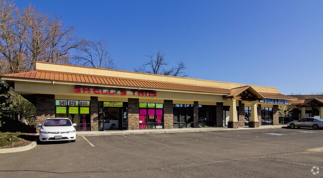

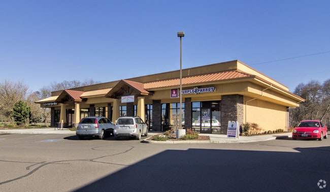
Property Detail
10522 Highway 62
10239255
Jackson
Commercialbuilding
Oregon
C-2
3
AE The base floodplain where base flood elevations are provided. AE Zones are now used on new format FIRMs instead of A1-A30 Zones.
2.14 AC
2025
Medford/Grants Pass
2026
Other Market Areas
001401
Medford, OR
22,500 SF
NEARBY LISTINGS FOR SALE OR LEASE
DEMOGRAPHICS near 10522 Highway 62
1 mile
3 mile
5 mile
2025 Total Population
5,772
21,141
24,904
2030 Population
5,777
20,990
24,717
Pop Growth 2025-2030
+ 0.09%
(0.71%)
(0.75%)
Average Age
44
41
41
2025 Total Households
2,329
7,583
8,876
HH Growth 2025-2030
+ 0.04%
(0.75%)
(0.82%)
Median Household Inc
$87,529
$81,419
$80,729
Avg Household Size
2.50
2.70
2.70
2025 Avg HH Vehicles
2.00
2.00
2.00
Median Home Value
$435,120
$373,769
$379,579
Median Year Built
1995
1994
1993
Nearby Places
Map Layers
Map Styles
 Street
 Aerial
Transit
 Traffic
 Biking
Places
Listings with unknown addresses are not visible on the map
- Restaurants
- Banks
- Shops
- Fitness
- Groceries
PUBLIC TRANSPORTATION
AIRPORT
Rogue Valley International - Medford
Drive
Walk
Distance
Rogue Valley International - Medford
16 min
10.2 mi
Freight Ports
Port of Coos Bay, OR
Drive
Walk
Distance
Port of Coos Bay, OR
224 min
168.1 mi
SALE & LEASE HISTORY
LISTING DATE
SALE/LEASE

Sep 25, 2016
For Lease
Nov 06, 2019
For Lease
May 03, 2018
For Lease
Nearby Properties
Address
Land Use
TOTAL SIZE
Lot Size
Zoning
Address
Land Use
TOTAL SIZE
Lot Size
Zoning
145.26 AC
GI
Address
Land Use
TOTAL SIZE
Lot Size
Zoning
28.59 AC
R-1-8
Address
Land Use
TOTAL SIZE
Lot Size
Zoning
170,304 SF
8.37 AC
R-1-8
Address
Land Use
TOTAL SIZE
Lot Size
Zoning
184,368 SF
10.24 AC
BP
Address
Land Use
TOTAL SIZE
Lot Size
Zoning
1,584 SF
2.01 AC
WCUR-30
Address
Land Use
TOTAL SIZE
Lot Size
Zoning
27.49 AC
WCUR-8
Address
Land Use
TOTAL SIZE
Lot Size
Zoning
6,108 SF
7.84 AC
GC
Address
Land Use
TOTAL SIZE
Lot Size
Zoning
38,767 SF
1.62 AC
R-4
Address
Land Use
TOTAL SIZE
Lot Size
Zoning
15,331 SF
6.79 AC
GC
Address
Land Use
TOTAL SIZE
Lot Size
Zoning
16 AC
GI
Address
Land Use
TOTAL SIZE
Lot Size
Zoning
16,602 SF
8.48 AC
GI
Address
Land Use
TOTAL SIZE
Lot Size
Zoning
43,732 SF
4.21 AC
GI
Address
Land Use
TOTAL SIZE
Lot Size
Zoning
7,844 SF
5.12 AC
WCUR-30
Address
Land Use
TOTAL SIZE
Lot Size
Zoning
100 SF
25.15 AC
WCUR-6
Address
Land Use
TOTAL SIZE
Lot Size
Zoning
8.83 AC
I-G
Address
Land Use
TOTAL SIZE
Lot Size
Zoning
24,830 SF
3.39 AC
WCUR-8
Address
Land Use
TOTAL SIZE
Lot Size
Zoning
76.88 AC
GI
Address
Land Use
TOTAL SIZE
Lot Size
Zoning
34,952 SF
2.40 AC
C-1
Address
Land Use
TOTAL SIZE
Lot Size
Zoning
128.63 AC
EFU
Address
Land Use
TOTAL SIZE
Lot Size
Zoning
7,700 SF
8.37 AC
R-1-8
Address
Land Use
TOTAL SIZE
Lot Size
Zoning
16,972 SF
2.10 AC
GI
Address
Land Use
TOTAL SIZE
Lot Size
Zoning
22.44 AC
WCUR-8
Address
Land Use
TOTAL SIZE
Lot Size
Zoning
46.76 AC
GI
Address
Land Use
TOTAL SIZE
Lot Size
Zoning
8,859 SF
6.65 AC
EFU
Address
Land Use
TOTAL SIZE
Lot Size
Zoning
10,756 SF
1 AC
GC
Address
Land Use
TOTAL SIZE
Lot Size
Zoning
15.97 AC
GI
Address
Land Use
TOTAL SIZE
Lot Size
Zoning
10.07 AC
GI
Address
Land Use
TOTAL SIZE
Lot Size
Zoning
4.42 AC
WCUR-8
Address
Land Use
TOTAL SIZE
Lot Size
Zoning
6.21 AC
GI
Address
Land Use
TOTAL SIZE
Lot Size
Zoning
2.27 AC
BP
The World's #1 Commercial Real Estate Marketplace
Connect with us
© 2026 CoStar Group
The information above has been obtained from sources believed reliable. While we do not doubt its accuracy we have not verified it and make no guarantee, warranty or representation about it. It is your responsibility to independently confirm its accuracy and completeness. Any projections, opinions, assumptions, or estimates used are for example only and do not represent the current or future performance of the property. The value of this transaction to you depends on tax and other factors which should be evaluated by your tax, financial, and legal advisors. You and your advisors should conduct a careful, independent investigation of the property to determine to your satisfaction the suitability of the property for your needs.