Property Record
1053 Us Route 302, Bartlett, NH 03812
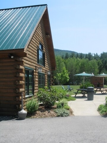

Property Detail
1053 Us Route 302
Commercialbuilding
Carroll
TOWN C
New Hampshire
B and X Area of moderate flood hazard, usually the area between the limits of the 100-year and 500-year floods.
281
2024
1.11 AC
2024
Other Market Areas
955102
BART-003302R-T000000L-000281-000001
1,365 SF
NEARBY LISTINGS FOR SALE OR LEASE
-
-
View all Bartlett listings for sale on LoopNet.com
DEMOGRAPHICS near 1053 Us Route 302
1 mile
3 mile
5 mile
2025 Total Population
99
424
1,216
2030 Population
92
392
1,133
Pop Growth 2025-2030
(7.07%)
(7.55%)
(6.83%)
Average Age
52
52
52
2025 Total Households
47
200
576
HH Growth 2025-2030
(8.51%)
(8.00%)
(6.77%)
Median Household Inc
$55,000
$55,147
$65,526
Avg Household Size
2.10
2.10
2.10
2025 Avg HH Vehicles
2.00
2.00
2.00
Median Home Value
$388,461
$420,000
$528,302
Median Year Built
1985
1985
1984
Nearby Places
Map Layers
Map Styles
 Street
 Aerial
Layers
 Traffic
 Biking
Places
Listings with unknown addresses are not visible on the map
- Restaurants
- Banks
- Shops
- Fitness
- Groceries
Nearby Properties
Address
Land Use
TOTAL SIZE
Lot Size
Zoning
Address
Land Use
TOTAL SIZE
Lot Size
Zoning
29,774 SF
195.17 AC
TOWN C
Address
Land Use
TOTAL SIZE
Lot Size
Zoning
57,090 SF
30.10 AC
TOWN R
Address
Land Use
TOTAL SIZE
Lot Size
Zoning
13,386 SF
659.62 AC
TOWN C
Address
Land Use
TOTAL SIZE
Lot Size
Zoning
1,430 SF
TOWN C
Address
Land Use
TOTAL SIZE
Lot Size
Zoning
1,673 SF
41.28 AC
TOWN C
Address
Land Use
TOTAL SIZE
Lot Size
Zoning
4,610 SF
2.90 AC
TOWN C
Address
Land Use
TOTAL SIZE
Lot Size
Zoning
5,319 SF
29.20 AC
TOWN C
Address
Land Use
TOTAL SIZE
Lot Size
Zoning
2,863 SF
12.81 AC
TOWN C
Address
Land Use
TOTAL SIZE
Lot Size
Zoning
2,295.68 AC
STANDA
Address
Land Use
TOTAL SIZE
Lot Size
Zoning
14,156 SF
2.35 AC
TOWN C
Address
Land Use
TOTAL SIZE
Lot Size
Zoning
8,600 SF
8.31 AC
TOWN C
Address
Land Use
TOTAL SIZE
Lot Size
Zoning
3,560 SF
2.60 AC
TOWN C
Address
Land Use
TOTAL SIZE
Lot Size
Zoning
708 SF
1.39 AC
TOWN R
Address
Land Use
TOTAL SIZE
Lot Size
Zoning
4,620 SF
2.88 AC
TOWN R
Address
Land Use
TOTAL SIZE
Lot Size
Zoning
5,509 SF
2.36 AC
TOWN C
Address
Land Use
TOTAL SIZE
Lot Size
Zoning
1,370 SF
2.84 AC
TOWN C
Address
Land Use
TOTAL SIZE
Lot Size
Zoning
7,007 SF
TOWN C
Address
Land Use
TOTAL SIZE
Lot Size
Zoning
6,911 SF
TOWN C
Address
Land Use
TOTAL SIZE
Lot Size
Zoning
7,010 SF
TOWN C
Address
Land Use
TOTAL SIZE
Lot Size
Zoning
7,002 SF
TOWN C
Address
Land Use
TOTAL SIZE
Lot Size
Zoning
3,557 SF
2.99 AC
TOWN C
Address
Land Use
TOTAL SIZE
Lot Size
Zoning
6,455 SF
TOWN C
Address
Land Use
TOTAL SIZE
Lot Size
Zoning
6,478 SF
TOWN C
Address
Land Use
TOTAL SIZE
Lot Size
Zoning
3,575 SF
5 AC
TOWN C
Address
Land Use
TOTAL SIZE
Lot Size
Zoning
103.07 AC
TOWN C
Address
Land Use
TOTAL SIZE
Lot Size
Zoning
4,557 SF
4.84 AC
TOWN C
Address
Land Use
TOTAL SIZE
Lot Size
Zoning
5,289 SF
TOWN C
Address
Land Use
TOTAL SIZE
Lot Size
Zoning
3,912 SF
14.10 AC
TOWN C
Address
Land Use
TOTAL SIZE
Lot Size
Zoning
3,829 SF
18.94 AC
TOWN C
Address
Land Use
TOTAL SIZE
Lot Size
Zoning
3,456 SF
1.20 AC
TOWN R
The World's #1 Commercial Real Estate Marketplace
Connect with us
© 2026 CoStar Group
The information above has been obtained from sources believed reliable. While we do not doubt its accuracy we have not verified it and make no guarantee, warranty or representation about it. It is your responsibility to independently confirm its accuracy and completeness. Any projections, opinions, assumptions, or estimates used are for example only and do not represent the current or future performance of the property. The value of this transaction to you depends on tax and other factors which should be evaluated by your tax, financial, and legal advisors. You and your advisors should conduct a careful, independent investigation of the property to determine to your satisfaction the suitability of the property for your needs.