Property Record
10532 Us Highway 20, Middlebury, IN 46540

NEARBY LISTINGS FOR SALE OR LEASE
-
-
View all Middlebury listings for sale on LoopNet.com
Property Detail
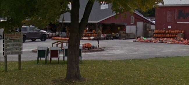
10532 Us Highway 20
Elkhart-Goshen, IN
Pumpkin Patch Market Pud
20-08-24-126-003.000-034
PUMPKIN PATCH MARKET PUD LOT 2
Storebuilding
Elkhart
AE
Indiana
18087C0145C
2
2024
2.22 AC
2025
Outlying Elkhart County
000801
South Bend/Mishawaka
2,520 SF
DEMOGRAPHICS near 10532 Us Highway 20
1 Mile
3 Mile
5 Mile
2024 Total Population
211
5,051
14,484
2029 Population
207
4,989
14,466
Pop Growth 2024-2029
(1.90%)
(1.23%)
(0.12%)
Average Age
34
36
34
2024 Total Households
62
1,624
4,375
HH Growth 2024-2029
(1.61%)
(1.54%)
(0.41%)
Median Household Inc
$83,035
$82,898
$89,429
Avg Household Size
3.50
3.10
3.30
2024 Avg HH Vehicles
1.00
2.00
2.00
Median Home Value
$356,249
$287,114
$302,905
Median Year Built
1989
1979
1983
Nearby Places
Map Layers
Map Styles
 Street
 Aerial
- Restaurants
- Banks
- Shops
- Fitness
- Groceries
PUBLIC TRANSPORTATION
AIRPORT
South Bend International
DRIVE
WALK
Distance
South Bend International
62 min
40.7 mi
Nearby Properties
Address
Land Use
TOTAL SIZE
Lot Size
Zoning
Address
Land Use
TOTAL SIZE
Lot Size
Zoning
1,516,881 SF
115.31 AC
ZO01
Address
Land Use
TOTAL SIZE
Lot Size
Zoning
357,464 SF
93.04 AC
ZO01
Address
Land Use
TOTAL SIZE
Lot Size
Zoning
262,890 SF
36.38 AC
ZO01
Address
Land Use
TOTAL SIZE
Lot Size
Zoning
300,178 SF
34.46 AC
ZO01
Address
Land Use
TOTAL SIZE
Lot Size
Zoning
951,390 SF
154.58 AC
ZO01
Address
Land Use
TOTAL SIZE
Lot Size
Zoning
199,089 SF
100 AC
ZO01
Address
Land Use
TOTAL SIZE
Lot Size
Zoning
249,990 SF
11.68 AC
ZO01
Address
Land Use
TOTAL SIZE
Lot Size
Zoning
287,049 SF
15.40 AC
ZO01
Address
Land Use
TOTAL SIZE
Lot Size
Zoning
1,087,012 SF
4.08 AC
ZO01
Address
Land Use
TOTAL SIZE
Lot Size
Zoning
167,041 SF
38.10 AC
ZO01
Address
Land Use
TOTAL SIZE
Lot Size
Zoning
265,704 SF
20.34 AC
ZO01
Address
Land Use
TOTAL SIZE
Lot Size
Zoning
335,093 SF
14.63 AC
ZO01
Address
Land Use
TOTAL SIZE
Lot Size
Zoning
177,992 SF
27.40 AC
ZO01
Address
Land Use
TOTAL SIZE
Lot Size
Zoning
87,303 SF
16.31 AC
ZO01
Address
Land Use
TOTAL SIZE
Lot Size
Zoning
198,134 SF
11.74 AC
ZO01
Address
Land Use
TOTAL SIZE
Lot Size
Zoning
248,192 SF
10.10 AC
ZO01
Address
Land Use
TOTAL SIZE
Lot Size
Zoning
152,448 SF
11.70 AC
ZO01
Address
Land Use
TOTAL SIZE
Lot Size
Zoning
102,600 SF
12.80 AC
ZO01
Address
Land Use
TOTAL SIZE
Lot Size
Zoning
226,136 SF
14.01 AC
ZO01
Address
Land Use
TOTAL SIZE
Lot Size
Zoning
109,341 SF
11.64 AC
ZO01
Address
Land Use
TOTAL SIZE
Lot Size
Zoning
172,029 SF
20 AC
ZO01
Address
Land Use
TOTAL SIZE
Lot Size
Zoning
82,500 SF
7.42 AC
ZO01
Address
Land Use
TOTAL SIZE
Lot Size
Zoning
37,360 SF
5.79 AC
ZO01
Address
Land Use
TOTAL SIZE
Lot Size
Zoning
48,915 SF
2.42 AC
ZO01
Address
Land Use
TOTAL SIZE
Lot Size
Zoning
23,655 SF
14.06 AC
ZO01
Address
Land Use
TOTAL SIZE
Lot Size
Zoning
75,878 SF
8.64 AC
ZO01
Address
Land Use
TOTAL SIZE
Lot Size
Zoning
83,207 SF
5 AC
ZO01
Address
Land Use
TOTAL SIZE
Lot Size
Zoning
69,600 SF
10 AC
ZO01
Address
Land Use
TOTAL SIZE
Lot Size
Zoning
62,136 SF
17.30 AC
ZO01
Address
Land Use
TOTAL SIZE
Lot Size
Zoning
159,864 SF
9.94 AC
ZO01
The World's #1 Commercial Real Estate Marketplace
Connect with us
© 2026 CoStar Group
The information above has been obtained from sources believed reliable. While we do not doubt its accuracy we have not verified it and make no guarantee, warranty or representation about it. It is your responsibility to independently confirm its accuracy and completeness. Any projections, opinions, assumptions, or estimates used are for example only and do not represent the current or future performance of the property. The value of this transaction to you depends on tax and other factors which should be evaluated by your tax, financial, and legal advisors. You and your advisors should conduct a careful, independent investigation of the property to determine to your satisfaction the suitability of the property for your needs.