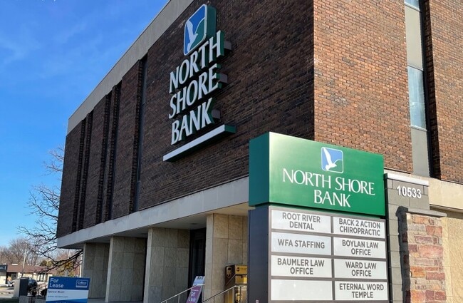
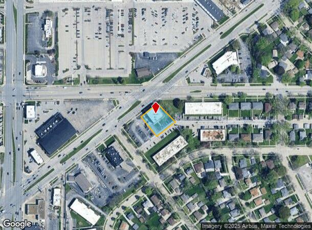
Property Record
10533 W National Ave, Milwaukee, WI 53227
Current Lease Availabilities
NEARBY LISTINGS FOR SALE OR LEASE
Property Detail
10533 W National Ave
Milwaukee-Waukesha-West Allis, WI
Milw Builders Assn Wildwood Estates
519-0002-006
MILW BUILDERS ASSN WILDWOOD ESTATES PT BLK 2 & VAC SERV ST & LANDS ADJ IN SW 8-6-21 COM 320FT NWLY OF SWLY COR SD BLK 2 TH SELY 141.31FT NELY 249FT NWLY 201.56FT SWLY 92.23FT SELY 60 FT TH SWLY TO BEG EX PT FOR AVE
Commercialnec
Milwaukee
X
Wisconsin
55133C0375G
0.77 AC
2023
West Allis
2024
Milwaukee/Madison
101100
DEMOGRAPHICS near 10533 W National Ave
1 Mile
3 Mile
5 Mile
2024 Total Population
13,050
114,254
269,251
2029 Population
12,722
112,795
266,267
Pop Growth 2024-2029
(2.51%)
(1.28%)
(1.11%)
Average Age
41
42
41
2024 Total Households
6,250
51,419
116,787
HH Growth 2024-2029
(2.58%)
(1.32%)
(1.16%)
Median Household Inc
$61,899
$68,208
$71,741
Avg Household Size
2.00
2.10
2.20
2024 Avg HH Vehicles
2.00
2.00
2.00
Median Home Value
$192,615
$207,728
$235,799
Median Year Built
1964
1961
1959
Nearby Places
- Restaurants
- Banks
- Shops
- Fitness
- Groceries
PUBLIC TRANSPORTATION
COMMUTER RAIL
DRIVE
WALK
Distance
15 min
8.8 mi
AIRPORT
General Mitchell International
DRIVE
WALK
Distance
General Mitchell International
20 min
11.0 mi
Freight Ports
Port Milwaukee
DRIVE
WALK
Distance
Port Milwaukee
19 min
7.3 mi
Nearby Properties
Address
Land Use
TOTAL SIZE
Lot Size
Zoning
Address
Land Use
TOTAL SIZE
Lot Size
Zoning
8.63 AC
C2
Address
Land Use
TOTAL SIZE
Lot Size
Zoning
4.07 AC
Address
Land Use
TOTAL SIZE
Lot Size
Zoning
36.11 AC
Address
Land Use
TOTAL SIZE
Lot Size
Zoning
6.74 AC
Address
Land Use
TOTAL SIZE
Lot Size
Zoning
20.36 AC
Address
Land Use
TOTAL SIZE
Lot Size
Zoning
Address
Land Use
TOTAL SIZE
Lot Size
Zoning
234,132 SF
22.70 AC
RM1
Address
Land Use
TOTAL SIZE
Lot Size
Zoning
230,726 SF
26.56 AC
RM1
Address
Land Use
TOTAL SIZE
Lot Size
Zoning
8.70 AC
Address
Land Use
TOTAL SIZE
Lot Size
Zoning
8,881 SF
7.52 AC
Address
Land Use
TOTAL SIZE
Lot Size
Zoning
13.39 AC
Address
Land Use
TOTAL SIZE
Lot Size
Zoning
370,169 SF
23.69 AC
RM1
Address
Land Use
TOTAL SIZE
Lot Size
Zoning
47.96 AC
TL
Address
Land Use
TOTAL SIZE
Lot Size
Zoning
18.79 AC
Address
Land Use
TOTAL SIZE
Lot Size
Zoning
Address
Land Use
TOTAL SIZE
Lot Size
Zoning
174,869 SF
17.40 AC
RM1
Address
Land Use
TOTAL SIZE
Lot Size
Zoning
20.61 AC
TL
Address
Land Use
TOTAL SIZE
Lot Size
Zoning
213,840 SF
13.95 AC
PUDR5
Address
Land Use
TOTAL SIZE
Lot Size
Zoning
Address
Land Use
TOTAL SIZE
Lot Size
Zoning
174,510 SF
7.37 AC
PD
Address
Land Use
TOTAL SIZE
Lot Size
Zoning
158,246 SF
11.34 AC
RM1
Address
Land Use
TOTAL SIZE
Lot Size
Zoning
164,825 SF
7.93 AC
PD
Address
Land Use
TOTAL SIZE
Lot Size
Zoning
7.55 AC
SP-INS
Address
Land Use
TOTAL SIZE
Lot Size
Zoning
159,673 SF
6.69 AC
PD
Address
Land Use
TOTAL SIZE
Lot Size
Zoning
5.31 AC
Address
Land Use
TOTAL SIZE
Lot Size
Zoning
229,921 SF
8.07 AC
PUD
Address
Land Use
TOTAL SIZE
Lot Size
Zoning
113,300 SF
5.60 AC
IL1
Address
Land Use
TOTAL SIZE
Lot Size
Zoning
2.03 AC
Address
Land Use
TOTAL SIZE
Lot Size
Zoning
66,893 SF
6.75 AC
B2
Address
Land Use
TOTAL SIZE
Lot Size
Zoning
The World's #1 Commercial Real Estate Marketplace
Connect with us
© 2025 CoStar Group
The information above has been obtained from sources believed reliable. While we do not doubt its accuracy we have not verified it and make no guarantee, warranty or representation about it. It is your responsibility to independently confirm its accuracy and completeness. Any projections, opinions, assumptions, or estimates used are for example only and do not represent the current or future performance of the property. The value of this transaction to you depends on tax and other factors which should be evaluated by your tax, financial, and legal advisors. You and your advisors should conduct a careful, independent investigation of the property to determine to your satisfaction the suitability of the property for your needs.