Property Record
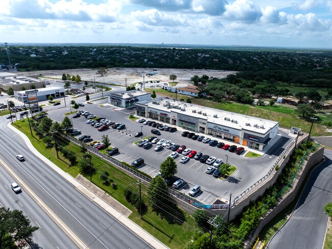
10538 Potranco Rd, San Antonio, TX 78251


NEARBY LISTINGS FOR SALE OR LEASE
Property Detail
10538 Potranco Rd
San Antonio-New Braunfels, TX
Ncb 19603 ( The Shops At Potranco)
19603-001-0150
NCB 19603 ( THE SHOPS AT POTRANCO), BLOCK 1, LOT 15 2021- NEW PER PLAT 20001/1940, FILED 03-27-2020.
Regionalshoppingcenterormallwithanchorstore
Bexar
X
Texas
48029C0365F
15
2024
2.34 AC
2025
Far West
171916
San Antonio
17,940 SF
DEMOGRAPHICS near 10538 Potranco Rd
1 Mile
3 Mile
5 Mile
2024 Total Population
16,401
125,257
273,822
2029 Population
17,172
133,541
292,826
Pop Growth 2024-2029
+ 4.70%
+ 6.61%
+ 6.94%
Average Age
35
34
35
2024 Total Households
5,173
41,287
92,556
HH Growth 2024-2029
+ 4.81%
+ 6.72%
+ 7.08%
Median Household Inc
$93,845
$80,165
$73,974
Avg Household Size
3.10
3.00
2.90
2024 Avg HH Vehicles
2.00
2.00
2.00
Median Home Value
$207,022
$215,263
$213,278
Median Year Built
2002
2004
2002
Nearby Places
Map Layers
Map Styles
 Street
 Aerial
- Restaurants
- Banks
- Shops
- Fitness
- Groceries
PUBLIC TRANSPORTATION
AIRPORT
San Antonio International
DRIVE
WALK
Distance
San Antonio International
24 min
16.0 mi
SALE & LEASE HISTORY
LISTING DATE
SALE/LEASE

Dec 09, 2024
For Lease
Apr 18, 2018
For Lease
Nearby Properties
Address
Land Use
TOTAL SIZE
Lot Size
Zoning
Address
Land Use
TOTAL SIZE
Lot Size
Zoning
486,228 SF
50.05 AC
Address
Land Use
TOTAL SIZE
Lot Size
Zoning
339,795 SF
24.27 AC
Address
Land Use
TOTAL SIZE
Lot Size
Zoning
315,000 SF
24.20 AC
Address
Land Use
TOTAL SIZE
Lot Size
Zoning
469,808 SF
36 AC
Address
Land Use
TOTAL SIZE
Lot Size
Zoning
443,726 SF
25.01 AC
Address
Land Use
TOTAL SIZE
Lot Size
Zoning
257,232 SF
66.01 AC
Address
Land Use
TOTAL SIZE
Lot Size
Zoning
236,594 SF
25.35 AC
Address
Land Use
TOTAL SIZE
Lot Size
Zoning
304,232 SF
99.80 AC
Address
Land Use
TOTAL SIZE
Lot Size
Zoning
185,751 SF
21.60 AC
Address
Land Use
TOTAL SIZE
Lot Size
Zoning
171,142 SF
21.60 AC
Address
Land Use
TOTAL SIZE
Lot Size
Zoning
352,500 SF
31.03 AC
Address
Land Use
TOTAL SIZE
Lot Size
Zoning
815,030 SF
111.97 AC
Address
Land Use
TOTAL SIZE
Lot Size
Zoning
341,212 SF
15 AC
Address
Land Use
TOTAL SIZE
Lot Size
Zoning
123,595 SF
21.60 AC
Address
Land Use
TOTAL SIZE
Lot Size
Zoning
331,109 SF
14.44 AC
Address
Land Use
TOTAL SIZE
Lot Size
Zoning
369,951 SF
21.42 AC
Address
Land Use
TOTAL SIZE
Lot Size
Zoning
361,708 SF
17.83 AC
Address
Land Use
TOTAL SIZE
Lot Size
Zoning
532,921 SF
21.80 AC
Address
Land Use
TOTAL SIZE
Lot Size
Zoning
50,135 SF
10.96 AC
Address
Land Use
TOTAL SIZE
Lot Size
Zoning
368,012 SF
22.27 AC
Address
Land Use
TOTAL SIZE
Lot Size
Zoning
336,383 SF
18.71 AC
Address
Land Use
TOTAL SIZE
Lot Size
Zoning
286,006 SF
13.43 AC
Address
Land Use
TOTAL SIZE
Lot Size
Zoning
375,203 SF
15.99 AC
Address
Land Use
TOTAL SIZE
Lot Size
Zoning
202,122 SF
20.56 AC
Address
Land Use
TOTAL SIZE
Lot Size
Zoning
608,644 SF
88.50 AC
Address
Land Use
TOTAL SIZE
Lot Size
Zoning
360,108 SF
24 AC
Address
Land Use
TOTAL SIZE
Lot Size
Zoning
299,795 SF
16.13 AC
Address
Land Use
TOTAL SIZE
Lot Size
Zoning
337,360 SF
13.33 AC
Address
Land Use
TOTAL SIZE
Lot Size
Zoning
302,851 SF
14.98 AC
Address
Land Use
TOTAL SIZE
Lot Size
Zoning
241,445 SF
15.86 AC
The World's #1 Commercial Real Estate Marketplace
Connect with us
© 2025 CoStar Group
The information above has been obtained from sources believed reliable. While we do not doubt its accuracy we have not verified it and make no guarantee, warranty or representation about it. It is your responsibility to independently confirm its accuracy and completeness. Any projections, opinions, assumptions, or estimates used are for example only and do not represent the current or future performance of the property. The value of this transaction to you depends on tax and other factors which should be evaluated by your tax, financial, and legal advisors. You and your advisors should conduct a careful, independent investigation of the property to determine to your satisfaction the suitability of the property for your needs.