Property Record
1054 Highway 19 N, Thomaston, GA 30286

NEARBY LISTINGS FOR SALE OR LEASE
-
-
View all Thomaston listings for sale on LoopNet.com
Property Detail
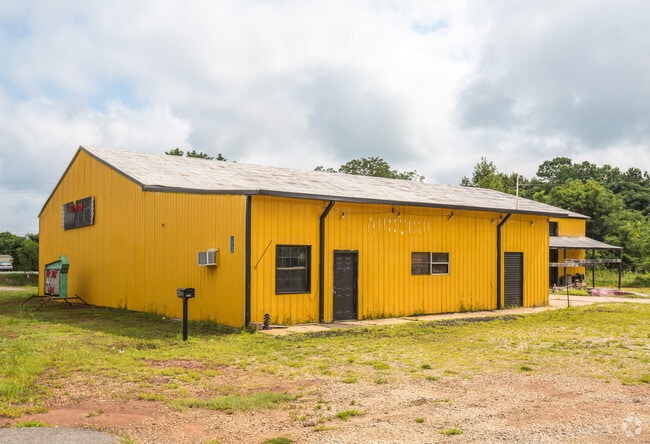
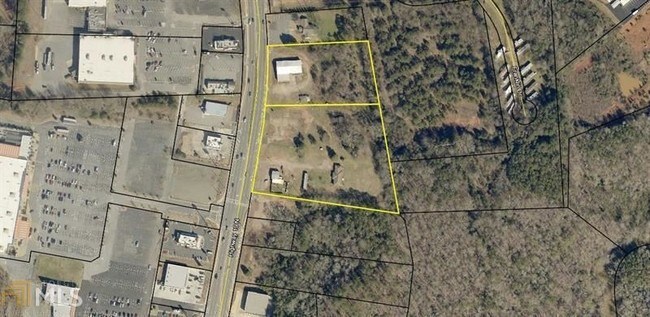
1054 Highway 19 N
Thomaston, GA
North Thomaston Commercial
043-036A
TRACT CFA (1.38349ACS) PB 32/182 CHICK FILA
Restaurantdrivein
Upson
2024
Georgia
2025
1.38 AC
010201
Georgia South Area
5,041 SF
Other Market Areas
DEMOGRAPHICS near 1054 Highway 19 N
1 Mile
3 Mile
5 Mile
2024 Total Population
2,297
13,959
21,242
2029 Population
2,340
14,396
21,939
Pop Growth 2024-2029
+ 1.87%
+ 3.13%
+ 3.28%
Average Age
40
41
41
2024 Total Households
944
5,719
8,617
HH Growth 2024-2029
+ 1.69%
+ 3.01%
+ 3.14%
Median Household Inc
$44,766
$40,896
$42,489
Avg Household Size
2.40
2.40
2.40
2024 Avg HH Vehicles
2.00
2.00
2.00
Median Home Value
$99,999
$106,960
$131,237
Median Year Built
1972
1969
1970
Nearby Places
Map Layers
Map Styles
 Street
 Aerial
- Restaurants
- Banks
- Shops
- Fitness
- Groceries
SALE & LEASE HISTORY
LISTING DATE
SALE/LEASE

Sep 13, 2017
For Sale
Jun 15, 2018
For Sale
Jul 12, 2017
For Sale
Nearby Properties
Address
Land Use
TOTAL SIZE
Lot Size
Zoning
Address
Land Use
TOTAL SIZE
Lot Size
Zoning
3,000 SF
73.70 AC
AR
Address
Land Use
TOTAL SIZE
Lot Size
Zoning
90,546 SF
87.05 AC
AR
Address
Land Use
TOTAL SIZE
Lot Size
Zoning
1,850 SF
94.56 AC
M2
Address
Land Use
TOTAL SIZE
Lot Size
Zoning
61,594 SF
31.44 AC
M1
Address
Land Use
TOTAL SIZE
Lot Size
Zoning
58,908 SF
104.55 AC
M1
Address
Land Use
TOTAL SIZE
Lot Size
Zoning
9,588 SF
12.17 AC
PI
Address
Land Use
TOTAL SIZE
Lot Size
Zoning
174,343 SF
18.48 AC
C2
Address
Land Use
TOTAL SIZE
Lot Size
Zoning
121,950 SF
12.57 AC
PI
Address
Land Use
TOTAL SIZE
Lot Size
Zoning
103,020 SF
11.06 AC
C2
Address
Land Use
TOTAL SIZE
Lot Size
Zoning
48,476 SF
17.80 AC
ES2
Address
Land Use
TOTAL SIZE
Lot Size
Zoning
140,288 SF
31.67 AC
M2
Address
Land Use
TOTAL SIZE
Lot Size
Zoning
322,698 SF
72.25 AC
M2
Address
Land Use
TOTAL SIZE
Lot Size
Zoning
27,502 SF
7 AC
PI
Address
Land Use
TOTAL SIZE
Lot Size
Zoning
34,436 SF
3.52 AC
MR
Address
Land Use
TOTAL SIZE
Lot Size
Zoning
31,412 SF
3.69 AC
DT
Address
Land Use
TOTAL SIZE
Lot Size
Zoning
125,647 SF
15.67 AC
C2
Address
Land Use
TOTAL SIZE
Lot Size
Zoning
34,537 SF
6.65 AC
C2
Address
Land Use
TOTAL SIZE
Lot Size
Zoning
24,662 SF
1.09 AC
DT
Address
Land Use
TOTAL SIZE
Lot Size
Zoning
28,266 SF
2.44 AC
PD
Address
Land Use
TOTAL SIZE
Lot Size
Zoning
488 SF
11.97 AC
MR
Address
Land Use
TOTAL SIZE
Lot Size
Zoning
13,765 SF
7.92 AC
PD
Address
Land Use
TOTAL SIZE
Lot Size
Zoning
4,472 SF
11.57 AC
MR
Address
Land Use
TOTAL SIZE
Lot Size
Zoning
61,916 SF
8.93 AC
C2
Address
Land Use
TOTAL SIZE
Lot Size
Zoning
247,227 SF
18.54 AC
M2
Address
Land Use
TOTAL SIZE
Lot Size
Zoning
4,704 SF
172.30 AC
M2
Address
Land Use
TOTAL SIZE
Lot Size
Zoning
30,719 SF
22.90 AC
PI
Address
Land Use
TOTAL SIZE
Lot Size
Zoning
44,356 SF
5.75 AC
AR
Address
Land Use
TOTAL SIZE
Lot Size
Zoning
21,373 SF
2.77 AC
C2
Address
Land Use
TOTAL SIZE
Lot Size
Zoning
5,640 SF
5 AC
MR
Address
Land Use
TOTAL SIZE
Lot Size
Zoning
19,660 SF
1.26 AC
DT
The World's #1 Commercial Real Estate Marketplace
Connect with us
© 2025 CoStar Group
The information above has been obtained from sources believed reliable. While we do not doubt its accuracy we have not verified it and make no guarantee, warranty or representation about it. It is your responsibility to independently confirm its accuracy and completeness. Any projections, opinions, assumptions, or estimates used are for example only and do not represent the current or future performance of the property. The value of this transaction to you depends on tax and other factors which should be evaluated by your tax, financial, and legal advisors. You and your advisors should conduct a careful, independent investigation of the property to determine to your satisfaction the suitability of the property for your needs.