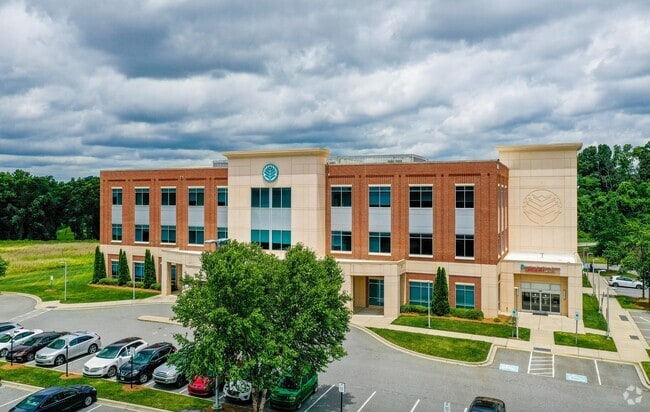
Property Record
10545 Blair Rd, Mint Hill, NC 28227


Current Lease Availabilities
NEARBY LISTINGS FOR SALE OR LEASE
Property Detail
10545 Blair Rd
Charlotte-Concord-Gastonia, NC-SC
TR 1 U/M
137-151-28A
Mecklenburg
Commercialnec
North Carolina
X
28
3710551300K
5.54 AC
2024
East Charlotte
2025
Charlotte
005719
DEMOGRAPHICS near 10545 Blair Rd
1 Mile
3 Mile
5 Mile
2024 Total Population
1,826
30,812
85,029
2029 Population
1,958
33,007
90,950
Pop Growth 2024-2029
+ 7.23%
+ 7.12%
+ 6.96%
Average Age
40
39
39
2024 Total Households
689
10,646
30,095
HH Growth 2024-2029
+ 7.11%
+ 7.01%
+ 6.79%
Median Household Inc
$91,874
$73,996
$73,792
Avg Household Size
2.60
2.80
2.80
2024 Avg HH Vehicles
2.00
2.00
2.00
Median Home Value
$363,636
$293,459
$298,579
Median Year Built
2004
1998
1994
Nearby Places
Map Layers
Map Styles
 Street
 Aerial
- Restaurants
- Banks
- Shops
- Fitness
- Groceries
PUBLIC TRANSPORTATION
AIRPORT
Charlotte/Douglas International
DRIVE
WALK
Distance
Charlotte/Douglas International
36 min
32.1 mi
Nearby Properties
Address
Land Use
TOTAL SIZE
Lot Size
Zoning
Address
Land Use
TOTAL SIZE
Lot Size
Zoning
261,708 SF
34.03 AC
Address
Land Use
TOTAL SIZE
Lot Size
Zoning
315,436 SF
23.89 AC
R3
Address
Land Use
TOTAL SIZE
Lot Size
Zoning
290,268 SF
19.96 AC
R17MFCD
Address
Land Use
TOTAL SIZE
Lot Size
Zoning
187,371 SF
7.31 AC
Address
Land Use
TOTAL SIZE
Lot Size
Zoning
333,774 SF
64.04 AC
I
Address
Land Use
TOTAL SIZE
Lot Size
Zoning
96,071 SF
7.44 AC
Address
Land Use
TOTAL SIZE
Lot Size
Zoning
239,983 SF
21.41 AC
I-G(CD)
Address
Land Use
TOTAL SIZE
Lot Size
Zoning
78,372 SF
14.08 AC
IGCUD
Address
Land Use
TOTAL SIZE
Lot Size
Zoning
58,134 SF
5.08 AC
IGCUD
Address
Land Use
TOTAL SIZE
Lot Size
Zoning
104,386 SF
13 AC
R4
Address
Land Use
TOTAL SIZE
Lot Size
Zoning
86,432 SF
20.01 AC
I
Address
Land Use
TOTAL SIZE
Lot Size
Zoning
104,214 SF
1.69 AC
MUDD-O
Address
Land Use
TOTAL SIZE
Lot Size
Zoning
62,619 SF
11.93 AC
I-G(CD)
Address
Land Use
TOTAL SIZE
Lot Size
Zoning
108,786 SF
9.95 AC
I1
Address
Land Use
TOTAL SIZE
Lot Size
Zoning
49,878 SF
6.11 AC
Address
Land Use
TOTAL SIZE
Lot Size
Zoning
108,250 SF
10.07 AC
CC
Address
Land Use
TOTAL SIZE
Lot Size
Zoning
73,255 SF
13.35 AC
R
Address
Land Use
TOTAL SIZE
Lot Size
Zoning
68,653 SF
17.30 AC
R3
Address
Land Use
TOTAL SIZE
Lot Size
Zoning
69,108 SF
14.95 AC
I-G(CD)
Address
Land Use
TOTAL SIZE
Lot Size
Zoning
3,614 SF
7.57 AC
NS
Address
Land Use
TOTAL SIZE
Lot Size
Zoning
54,051 SF
25.06 AC
CR
Address
Land Use
TOTAL SIZE
Lot Size
Zoning
21,001 SF
20.22 AC
R
Address
Land Use
TOTAL SIZE
Lot Size
Zoning
720 SF
35.60 AC
O-2(CD)
Address
Land Use
TOTAL SIZE
Lot Size
Zoning
20,808 SF
1.56 AC
B-D DO-B
Address
Land Use
TOTAL SIZE
Lot Size
Zoning
10,852 SF
10.64 AC
BG
Address
Land Use
TOTAL SIZE
Lot Size
Zoning
188.38 AC
R-3
Address
Land Use
TOTAL SIZE
Lot Size
Zoning
5,528 SF
174.55 AC
O-1
Address
Land Use
TOTAL SIZE
Lot Size
Zoning
52,600 SF
4.32 AC
Address
Land Use
TOTAL SIZE
Lot Size
Zoning
37,502 SF
24.21 AC
R
Address
Land Use
TOTAL SIZE
Lot Size
Zoning
20,903 SF
1.49 AC
The World's #1 Commercial Real Estate Marketplace
Connect with us
© 2025 CoStar Group
The information above has been obtained from sources believed reliable. While we do not doubt its accuracy we have not verified it and make no guarantee, warranty or representation about it. It is your responsibility to independently confirm its accuracy and completeness. Any projections, opinions, assumptions, or estimates used are for example only and do not represent the current or future performance of the property. The value of this transaction to you depends on tax and other factors which should be evaluated by your tax, financial, and legal advisors. You and your advisors should conduct a careful, independent investigation of the property to determine to your satisfaction the suitability of the property for your needs.