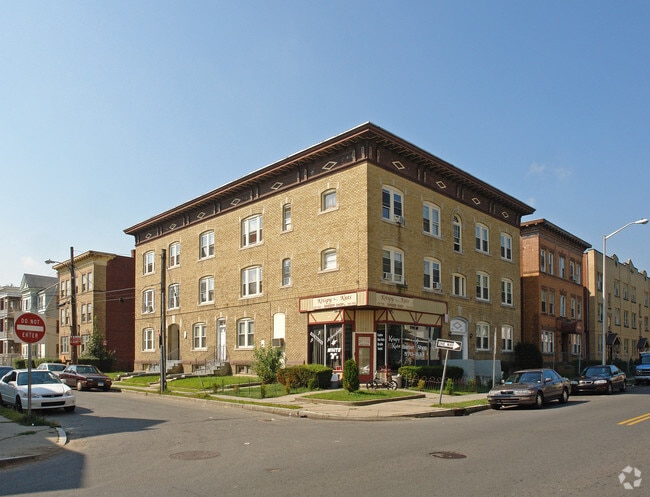
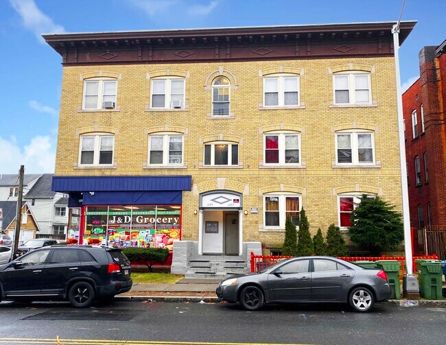
Property Record
1055 Capitol Ave, Hartford, CT 06106
NEARBY LISTINGS FOR SALE OR LEASE
Property Detail
1055 Capitol Ave
HTFD-000135-000374-000006
Hartford
Commercialofficeresidentialmixeduse
Connecticut
X
6
09003C0364F
0.20 AC
2024
Hartford
2025
Hartford
524501
Hartford-West Hartford-East Hartford, CT
11,050 SF
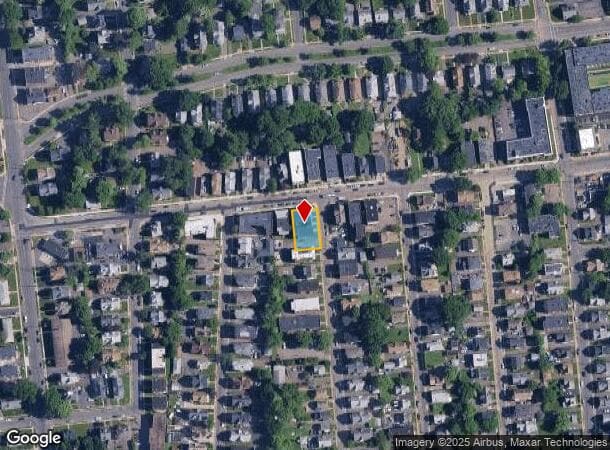
DEMOGRAPHICS near 1055 Capitol Ave
1 Mile
3 Mile
5 Mile
2024 Total Population
29,558
167,355
258,704
2029 Population
29,396
166,482
257,389
Pop Growth 2024-2029
(0.55%)
(0.52%)
(0.51%)
Average Age
40
38
39
2024 Total Households
13,878
67,245
103,903
HH Growth 2024-2029
(0.43%)
(0.36%)
(0.43%)
Median Household Inc
$44,761
$54,415
$62,726
Avg Household Size
2.00
2.30
2.30
2024 Avg HH Vehicles
1.00
1.00
1.00
Median Home Value
$281,915
$281,522
$263,986
Median Year Built
1950
1952
1955
Nearby Places
Map Layers
Map Styles
 Street
 Aerial
- Restaurants
- Banks
- Shops
- Fitness
- Groceries
PUBLIC TRANSPORTATION
COMMUTER RAIL
DRIVE
WALK
Distance
5 min
2.1 mi
DRIVE
WALK
Distance
5 min
2.1 mi
AIRPORT
Bradley International
DRIVE
WALK
Distance
Bradley International
29 min
17.2 mi
Tweed/New Haven
DRIVE
WALK
Distance
Tweed/New Haven
59 min
41.7 mi
Freight Ports
Port of New Haven
DRIVE
WALK
Distance
Port of New Haven
54 min
40.6 mi
SALE & LEASE HISTORY
LISTING DATE
SALE/LEASE

Sep 24, 2016
For Sale
Jun 01, 2020
For Sale
Nearby Properties
Address
Land Use
TOTAL SIZE
Lot Size
Zoning
Address
Land Use
TOTAL SIZE
Lot Size
Zoning
147,644 SF
0.19 AC
CAMP
Address
Land Use
TOTAL SIZE
Lot Size
Zoning
88.48 AC
R-10
Address
Land Use
TOTAL SIZE
Lot Size
Zoning
173,601 SF
1.56 AC
DT-1
Address
Land Use
TOTAL SIZE
Lot Size
Zoning
516,804 SF
32.98 AC
CAMP
Address
Land Use
TOTAL SIZE
Lot Size
Zoning
482,566 SF
0.65 AC
DT-2
Address
Land Use
TOTAL SIZE
Lot Size
Zoning
15.73 AC
CAMP
Address
Land Use
TOTAL SIZE
Lot Size
Zoning
4.13 AC
DT-1
Address
Land Use
TOTAL SIZE
Lot Size
Zoning
1.45 AC
CAMP
Address
Land Use
TOTAL SIZE
Lot Size
Zoning
213,017 SF
6.21 AC
DT-3
Address
Land Use
TOTAL SIZE
Lot Size
Zoning
2.90 AC
DT-2
Address
Land Use
TOTAL SIZE
Lot Size
Zoning
8.89 AC
MX-2
Address
Land Use
TOTAL SIZE
Lot Size
Zoning
29.35 AC
CAMP
Address
Land Use
TOTAL SIZE
Lot Size
Zoning
584 AC
OS
Address
Land Use
TOTAL SIZE
Lot Size
Zoning
1,125,149 SF
1.14 AC
DT-1
Address
Land Use
TOTAL SIZE
Lot Size
Zoning
5.56 AC
CAMP
Address
Land Use
TOTAL SIZE
Lot Size
Zoning
205,719 SF
12.15 AC
MX-2
Address
Land Use
TOTAL SIZE
Lot Size
Zoning
3,605 SF
28.33 AC
R-6,RM
Address
Land Use
TOTAL SIZE
Lot Size
Zoning
28.02 AC
CAMP
Address
Land Use
TOTAL SIZE
Lot Size
Zoning
416,762 SF
20 AC
CAMP
Address
Land Use
TOTAL SIZE
Lot Size
Zoning
7.45 AC
CAMP
Address
Land Use
TOTAL SIZE
Lot Size
Zoning
20.41 AC
MX-2
Address
Land Use
TOTAL SIZE
Lot Size
Zoning
310,901 SF
28.75 AC
MX-2
Address
Land Use
TOTAL SIZE
Lot Size
Zoning
197,704 SF
1.82 AC
CAMP
Address
Land Use
TOTAL SIZE
Lot Size
Zoning
40,632 SF
1.10 AC
NX-1
Address
Land Use
TOTAL SIZE
Lot Size
Zoning
4.76 AC
MX-2
Address
Land Use
TOTAL SIZE
Lot Size
Zoning
9,238 SF
28.35 AC
R-10,R
Address
Land Use
TOTAL SIZE
Lot Size
Zoning
6.63 AC
DT-1
Address
Land Use
TOTAL SIZE
Lot Size
Zoning
2.13 AC
DT-1
Address
Land Use
TOTAL SIZE
Lot Size
Zoning
4.50 AC
DT-1
Address
Land Use
TOTAL SIZE
Lot Size
Zoning
23.10 AC
R-20
The World's #1 Commercial Real Estate Marketplace
Connect with us
© 2025 CoStar Group
The information above has been obtained from sources believed reliable. While we do not doubt its accuracy we have not verified it and make no guarantee, warranty or representation about it. It is your responsibility to independently confirm its accuracy and completeness. Any projections, opinions, assumptions, or estimates used are for example only and do not represent the current or future performance of the property. The value of this transaction to you depends on tax and other factors which should be evaluated by your tax, financial, and legal advisors. You and your advisors should conduct a careful, independent investigation of the property to determine to your satisfaction the suitability of the property for your needs.