Property Record
1055 County Road E E, Saint Paul, MN 55110
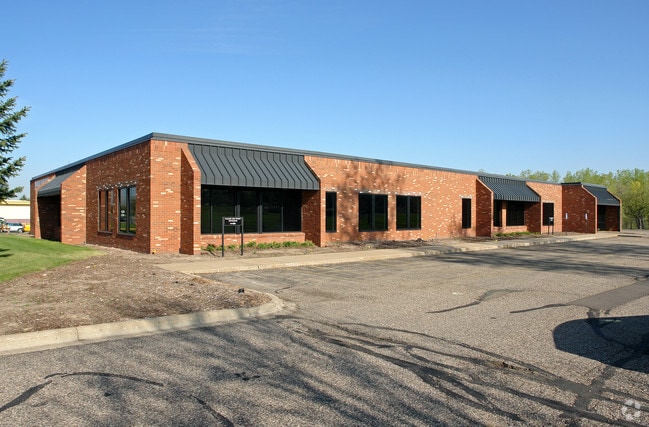

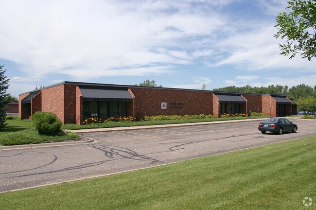
Property Detail
1055 County Road E E
28-30-22-43-0027
SECTION 28 TOWN 30 RANGE 22 EX TH PT OF S 1/2 OF S 1/2 OF THE SE 1/4 ...TO RD ) IN SEC 28 TN 30 RN 22
Officebuilding
RAMSEY
B and X Area of moderate flood hazard, usually the area between the limits of the 100-year and 500-year floods.
Minnesota
2024
2.06 AC
2025
Suburban St Paul
040605
Minneapolis/St Paul
15,834 SF
Minneapolis-St. Paul-Bloomington, MN-WI
NEARBY LISTINGS FOR SALE OR LEASE
DEMOGRAPHICS near 1055 County Road E E
1 mile
3 mile
5 mile
2025 Total Population
2,535
54,858
172,810
2030 Population
2,529
54,905
173,061
Pop Growth 2025-2030
(0.24%)
+ 0.09%
+ 0.15%
Average Age
42
43
41
2025 Total Households
1,087
22,388
67,879
HH Growth 2025-2030
(0.37%)
(0.12%)
+ 0.07%
Median Household Inc
$79,864
$86,292
$87,581
Avg Household Size
2.30
2.40
2.50
2025 Avg HH Vehicles
2.00
2.00
2.00
Median Home Value
$315,428
$336,724
$333,800
Median Year Built
1986
1982
1975
Nearby Places
Map Layers
Map Styles
 Street
 Aerial
Transit
 Traffic
 Biking
Places
Listings with unknown addresses are not visible on the map
- Restaurants
- Banks
- Shops
- Fitness
- Groceries
PUBLIC TRANSPORTATION
COMMUTER RAIL
Drive
Walk
Distance
13 min
8.8 mi
AIRPORT
Minneapolis-St Paul International/Wold-Chamberlain
Drive
Walk
Distance
Minneapolis-St Paul International/Wold-Chamberlain
27 min
17.9 mi
SALE & LEASE HISTORY
LISTING DATE
SALE/LEASE

Sep 25, 2016
For Lease
Nearby Properties
Address
Land Use
TOTAL SIZE
Lot Size
Zoning
Address
Land Use
TOTAL SIZE
Lot Size
Zoning
267,576 SF
18.95 AC
Address
Land Use
TOTAL SIZE
Lot Size
Zoning
2.39 AC
Address
Land Use
TOTAL SIZE
Lot Size
Zoning
5.59 AC
Address
Land Use
TOTAL SIZE
Lot Size
Zoning
13.44 AC
Address
Land Use
TOTAL SIZE
Lot Size
Zoning
4,800 SF
20.36 AC
Address
Land Use
TOTAL SIZE
Lot Size
Zoning
250,050 SF
2.99 AC
Address
Land Use
TOTAL SIZE
Lot Size
Zoning
106,400 SF
18.29 AC
Address
Land Use
TOTAL SIZE
Lot Size
Zoning
233,419 SF
5.67 AC
Address
Land Use
TOTAL SIZE
Lot Size
Zoning
78,163 SF
5.62 AC
Address
Land Use
TOTAL SIZE
Lot Size
Zoning
74,082 SF
12.10 AC
Address
Land Use
TOTAL SIZE
Lot Size
Zoning
212,663 SF
3.50 AC
Address
Land Use
TOTAL SIZE
Lot Size
Zoning
159.37 AC
Address
Land Use
TOTAL SIZE
Lot Size
Zoning
90,293 SF
9.33 AC
Address
Land Use
TOTAL SIZE
Lot Size
Zoning
Address
Land Use
TOTAL SIZE
Lot Size
Zoning
1,500 SF
25.38 AC
Address
Land Use
TOTAL SIZE
Lot Size
Zoning
211,420 SF
5.22 AC
Address
Land Use
TOTAL SIZE
Lot Size
Zoning
17.16 AC
Address
Land Use
TOTAL SIZE
Lot Size
Zoning
212,078 SF
2.95 AC
Address
Land Use
TOTAL SIZE
Lot Size
Zoning
118,442 SF
12.83 AC
Address
Land Use
TOTAL SIZE
Lot Size
Zoning
271,355 SF
20.56 AC
Address
Land Use
TOTAL SIZE
Lot Size
Zoning
126,852 SF
11.86 AC
Address
Land Use
TOTAL SIZE
Lot Size
Zoning
67,693 SF
7.30 AC
Address
Land Use
TOTAL SIZE
Lot Size
Zoning
960 SF
17.11 AC
Address
Land Use
TOTAL SIZE
Lot Size
Zoning
209,830 SF
10.06 AC
Address
Land Use
TOTAL SIZE
Lot Size
Zoning
138,655 SF
4.70 AC
Address
Land Use
TOTAL SIZE
Lot Size
Zoning
123,360 SF
14.50 AC
Address
Land Use
TOTAL SIZE
Lot Size
Zoning
1,344 SF
14.08 AC
Address
Land Use
TOTAL SIZE
Lot Size
Zoning
7,008 SF
140.89 AC
Address
Land Use
TOTAL SIZE
Lot Size
Zoning
48,400 SF
32.18 AC
Address
Land Use
TOTAL SIZE
Lot Size
Zoning
163,709 SF
1.22 AC
The World's #1 Commercial Real Estate Marketplace
Connect with us
© 2026 CoStar Group
The information above has been obtained from sources believed reliable. While we do not doubt its accuracy we have not verified it and make no guarantee, warranty or representation about it. It is your responsibility to independently confirm its accuracy and completeness. Any projections, opinions, assumptions, or estimates used are for example only and do not represent the current or future performance of the property. The value of this transaction to you depends on tax and other factors which should be evaluated by your tax, financial, and legal advisors. You and your advisors should conduct a careful, independent investigation of the property to determine to your satisfaction the suitability of the property for your needs.