Property Record
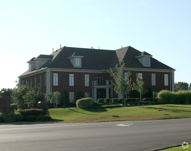
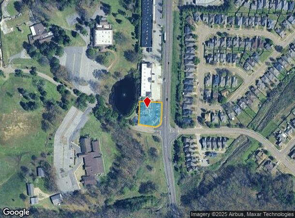
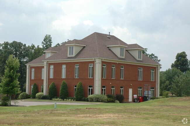
1055 N Houston Levee Rd, Cordova, TN 38018

NEARBY LISTINGS FOR SALE OR LEASE
Property Detail
1055 N Houston Levee Rd
D0-215-0-0542
Woodland Hills Pd Phase 5 Parcel 6
Officebuilding
WS HOUSTON LEVEE RD SEE MAP D2-15
X
Shelby
47157C0340F
Tennessee
0
0.54 AC
2025
Northeast
021020
Memphis
12,198 SF
Memphis, TN-MS-AR
DEMOGRAPHICS near 1055 N Houston Levee Rd
1 Mile
3 Mile
5 Mile
2024 Total Population
6,481
30,899
94,729
2029 Population
6,314
30,003
92,244
Pop Growth 2024-2029
(2.58%)
(2.90%)
(2.62%)
Average Age
37
38
39
2024 Total Households
2,425
11,387
37,083
HH Growth 2024-2029
(2.68%)
(3.04%)
(2.69%)
Median Household Inc
$90,736
$95,430
$86,173
Avg Household Size
2.60
2.70
2.50
2024 Avg HH Vehicles
2.00
2.00
2.00
Median Home Value
$355,555
$282,942
$274,038
Median Year Built
2004
2000
1994
Nearby Places
Map Layers
Map Styles
 Street
 Aerial
- Restaurants
- Banks
- Shops
- Fitness
- Groceries
PUBLIC TRANSPORTATION
AIRPORT
Memphis International
DRIVE
WALK
Distance
Memphis International
40 min
23.0 mi
SALE & LEASE HISTORY
LISTING DATE
SALE/LEASE

Sep 24, 2016
For Lease
Jun 16, 2020
For Lease
Aug 01, 2017
For Lease
Nearby Properties
Address
Land Use
TOTAL SIZE
Lot Size
Zoning
Address
Land Use
TOTAL SIZE
Lot Size
Zoning
93,713 SF
17.70 AC
CA
Address
Land Use
TOTAL SIZE
Lot Size
Zoning
35,313 SF
22.81 AC
RU-3
Address
Land Use
TOTAL SIZE
Lot Size
Zoning
38,480 SF
24.03 AC
CA
Address
Land Use
TOTAL SIZE
Lot Size
Zoning
29,090 SF
22.71 AC
CA
Address
Land Use
TOTAL SIZE
Lot Size
Zoning
83,822 SF
25.27 AC
CA
Address
Land Use
TOTAL SIZE
Lot Size
Zoning
36,966 SF
16.83 AC
CA
Address
Land Use
TOTAL SIZE
Lot Size
Zoning
29,090 SF
11.51 AC
CA
Address
Land Use
TOTAL SIZE
Lot Size
Zoning
31,368 SF
26.18 AC
CA
Address
Land Use
TOTAL SIZE
Lot Size
Zoning
149.79 AC
CA
Address
Land Use
TOTAL SIZE
Lot Size
Zoning
43,500 SF
4.31 AC
EMP
Address
Land Use
TOTAL SIZE
Lot Size
Zoning
50,305 SF
4.66 AC
CA
Address
Land Use
TOTAL SIZE
Lot Size
Zoning
22,268 SF
74.53 AC
CA
Address
Land Use
TOTAL SIZE
Lot Size
Zoning
77,083 SF
7.61 AC
EMP
Address
Land Use
TOTAL SIZE
Lot Size
Zoning
19,375 SF
2 AC
CA
Address
Land Use
TOTAL SIZE
Lot Size
Zoning
56,950 SF
7.39 AC
CA
Address
Land Use
TOTAL SIZE
Lot Size
Zoning
31,672 SF
15.04 AC
CA
Address
Land Use
TOTAL SIZE
Lot Size
Zoning
56,764 SF
5.10 AC
CA
Address
Land Use
TOTAL SIZE
Lot Size
Zoning
26,605 SF
4.39 AC
R-6
Address
Land Use
TOTAL SIZE
Lot Size
Zoning
34.53 AC
CA
Address
Land Use
TOTAL SIZE
Lot Size
Zoning
11,800 SF
1.41 AC
CMU-1
Address
Land Use
TOTAL SIZE
Lot Size
Zoning
20,400 SF
1.88 AC
CA
Address
Land Use
TOTAL SIZE
Lot Size
Zoning
7,601 SF
1.84 AC
CA
Address
Land Use
TOTAL SIZE
Lot Size
Zoning
14,620 SF
0.68 AC
CA
Address
Land Use
TOTAL SIZE
Lot Size
Zoning
55,470 SF
3.05 AC
CA
Address
Land Use
TOTAL SIZE
Lot Size
Zoning
55.53 AC
CA
Address
Land Use
TOTAL SIZE
Lot Size
Zoning
10,732 SF
10 AC
CA
Address
Land Use
TOTAL SIZE
Lot Size
Zoning
45,632 SF
1.21 AC
CA
Address
Land Use
TOTAL SIZE
Lot Size
Zoning
10,600 SF
2.51 AC
CA
Address
Land Use
TOTAL SIZE
Lot Size
Zoning
11,390 SF
6.05 AC
CA
Address
Land Use
TOTAL SIZE
Lot Size
Zoning
8.32 AC
R-6
The World's #1 Commercial Real Estate Marketplace
Connect with us
© 2025 CoStar Group
The information above has been obtained from sources believed reliable. While we do not doubt its accuracy we have not verified it and make no guarantee, warranty or representation about it. It is your responsibility to independently confirm its accuracy and completeness. Any projections, opinions, assumptions, or estimates used are for example only and do not represent the current or future performance of the property. The value of this transaction to you depends on tax and other factors which should be evaluated by your tax, financial, and legal advisors. You and your advisors should conduct a careful, independent investigation of the property to determine to your satisfaction the suitability of the property for your needs.