Property Record
1055 Lewiston Rd, New Gloucester, ME 04260
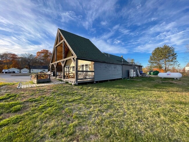

This Property Is For Sale
Property Detail
1055 Lewiston Rd
NEWG-000019-000000-000028
CUMBERLAND
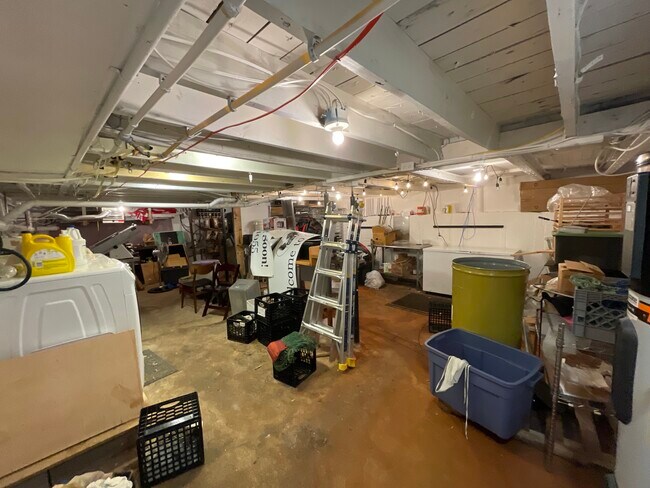
Restaurantbuilding
Maine
RURAL
28
B and X Area of moderate flood hazard, usually the area between the limits of the 100-year and 500-year floods.
1.50 AC
2025
NE Cumberland County
2025
Portland/South Portland
011500
Portland-South Portland, ME
2,062 SF
NEARBY LISTINGS FOR SALE OR LEASE
-
-
View all New Gloucester listings for sale on LoopNet.com
DEMOGRAPHICS near 1055 Lewiston Rd
1 mile
3 mile
5 mile
2025 Total Population
660
2,955
9,536
2030 Population
658
2,963
9,649
Pop Growth 2025-2030
(0.30%)
+ 0.27%
+ 1.18%
Average Age
43
43
43
2025 Total Households
255
1,151
3,738
HH Growth 2025-2030
0.00%
+ 0.52%
+ 1.58%
Median Household Inc
$114,540
$110,309
$106,930
Avg Household Size
2.60
2.50
2.50
2025 Avg HH Vehicles
2.00
2.00
2.00
Median Home Value
$320,225
$341,770
$346,176
Median Year Built
1980
1980
1985
Nearby Places
Map Layers
Map Styles
 Street
 Aerial
Layers
 Traffic
 Biking
Places
Listings with unknown addresses are not visible on the map
- Restaurants
- Banks
- Shops
- Fitness
- Groceries
PUBLIC TRANSPORTATION
AIRPORT
Portland International Jetport
Drive
Walk
Distance
Portland International Jetport
39 min
27.2 mi
Freight Ports
Portland, ME
Drive
Walk
Distance
Portland, ME
41 min
26.9 mi
Nearby Properties
Address
Land Use
TOTAL SIZE
Lot Size
Zoning
Address
Land Use
TOTAL SIZE
Lot Size
Zoning
25 AC
BB
Address
Land Use
TOTAL SIZE
Lot Size
Zoning
104,472 SF
101.68 AC
Address
Land Use
TOTAL SIZE
Lot Size
Zoning
17.34 AC
SEASON
Address
Land Use
TOTAL SIZE
Lot Size
Zoning
58,792 SF
7.35 AC
Address
Land Use
TOTAL SIZE
Lot Size
Zoning
Address
Land Use
TOTAL SIZE
Lot Size
Zoning
20,912 SF
20.47 AC
Address
Land Use
TOTAL SIZE
Lot Size
Zoning
11,192 SF
5 AC
Address
Land Use
TOTAL SIZE
Lot Size
Zoning
270.38 AC
BB
Address
Land Use
TOTAL SIZE
Lot Size
Zoning
40,500 SF
10.73 AC
Address
Land Use
TOTAL SIZE
Lot Size
Zoning
12.50 AC
SEASON
Address
Land Use
TOTAL SIZE
Lot Size
Zoning
3.27 AC
15
Address
Land Use
TOTAL SIZE
Lot Size
Zoning
7.60 AC
RA
Address
Land Use
TOTAL SIZE
Lot Size
Zoning
10,408 SF
2.10 AC
Address
Land Use
TOTAL SIZE
Lot Size
Zoning
Address
Land Use
TOTAL SIZE
Lot Size
Zoning
2,336 SF
121.86 AC
BB
Address
Land Use
TOTAL SIZE
Lot Size
Zoning
12.75 AC
RURAL
Address
Land Use
TOTAL SIZE
Lot Size
Zoning
24,647 SF
3.44 AC
Address
Land Use
TOTAL SIZE
Lot Size
Zoning
65.19 AC
Address
Land Use
TOTAL SIZE
Lot Size
Zoning
19.47 AC
Address
Land Use
TOTAL SIZE
Lot Size
Zoning
20.87 AC
BB
Address
Land Use
TOTAL SIZE
Lot Size
Zoning
1,884 SF
6.96 AC
RA
Address
Land Use
TOTAL SIZE
Lot Size
Zoning
1 AC
RURAL
Address
Land Use
TOTAL SIZE
Lot Size
Zoning
3.40 AC
Address
Land Use
TOTAL SIZE
Lot Size
Zoning
9.36 AC
Address
Land Use
TOTAL SIZE
Lot Size
Zoning
0.63 AC
15
Address
Land Use
TOTAL SIZE
Lot Size
Zoning
3.46 AC
RURAL
Address
Land Use
TOTAL SIZE
Lot Size
Zoning
1,083 SF
10.11 AC
Address
Land Use
TOTAL SIZE
Lot Size
Zoning
10,800 SF
2.55 AC
Address
Land Use
TOTAL SIZE
Lot Size
Zoning
1 AC
RURAL
Address
Land Use
TOTAL SIZE
Lot Size
Zoning
1,200 SF
8 AC
SEASON
The World's #1 Commercial Real Estate Marketplace
Connect with us
© 2026 CoStar Group
The information above has been obtained from sources believed reliable. While we do not doubt its accuracy we have not verified it and make no guarantee, warranty or representation about it. It is your responsibility to independently confirm its accuracy and completeness. Any projections, opinions, assumptions, or estimates used are for example only and do not represent the current or future performance of the property. The value of this transaction to you depends on tax and other factors which should be evaluated by your tax, financial, and legal advisors. You and your advisors should conduct a careful, independent investigation of the property to determine to your satisfaction the suitability of the property for your needs.