Property Record
1055 Ruth St, Prescott, AZ 86301
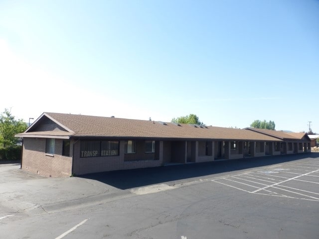

Property Detail
1055 Ruth St
Prescott, AZ
A RECT PCL NE4SW4 NW COR APPROX 1720E 314S FROM W4 COR 28-14-2W CONT .89AC 4419/372
116-19-010B
YAVAPAI
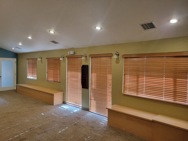
Medicalbuilding
Arizona
B and X Area of moderate flood hazard, usually the area between the limits of the 100-year and 500-year floods.
7
2025
0.89 AC
2027
Prescott & Sedona
000902
Other Market Areas
6,344 SF
NEARBY LISTINGS FOR SALE OR LEASE
DEMOGRAPHICS near 1055 Ruth St
1 mile
3 mile
5 mile
2025 Total Population
7,576
44,733
58,899
2030 Population
7,913
47,503
62,606
Pop Growth 2025-2030
+ 4.45%
+ 6.19%
+ 6.29%
Average Age
48
51
52
2025 Total Households
3,532
21,747
28,096
HH Growth 2025-2030
+ 4.53%
+ 6.28%
+ 6.44%
Median Household Inc
$62,924
$68,574
$71,303
Avg Household Size
2.00
2.00
2.00
2025 Avg HH Vehicles
2.00
2.00
2.00
Median Home Value
$424,393
$585,518
$599,970
Median Year Built
1986
1991
1992
Nearby Places
Map Layers
Map Styles
 Street
 Aerial
Layers
 Traffic
 Biking
Places
Listings with unknown addresses are not visible on the map
- Restaurants
- Banks
- Shops
- Fitness
- Groceries
SALE & LEASE HISTORY
LISTING DATE
SALE/LEASE

Sep 25, 2016
For Lease
Sep 24, 2016
For Sale
Sep 17, 2021
For Lease
Dec 05, 2023
For Lease
Aug 29, 2021
For Sale
Nearby Properties
Address
Land Use
TOTAL SIZE
Lot Size
Zoning
Address
Land Use
TOTAL SIZE
Lot Size
Zoning
633,861 SF
21.72 AC
Address
Land Use
TOTAL SIZE
Lot Size
Zoning
334,628 SF
15.03 AC
Address
Land Use
TOTAL SIZE
Lot Size
Zoning
127,271 SF
11.10 AC
Address
Land Use
TOTAL SIZE
Lot Size
Zoning
73,133 SF
75.73 AC
Address
Land Use
TOTAL SIZE
Lot Size
Zoning
288,789 SF
24.01 AC
Address
Land Use
TOTAL SIZE
Lot Size
Zoning
103,382 SF
3.43 AC
Address
Land Use
TOTAL SIZE
Lot Size
Zoning
17,200 SF
88.32 AC
Address
Land Use
TOTAL SIZE
Lot Size
Zoning
129,685 SF
2.20 AC
Address
Land Use
TOTAL SIZE
Lot Size
Zoning
110,011 SF
8.04 AC
Address
Land Use
TOTAL SIZE
Lot Size
Zoning
67,239 SF
Address
Land Use
TOTAL SIZE
Lot Size
Zoning
142,636 SF
1.14 AC
Address
Land Use
TOTAL SIZE
Lot Size
Zoning
30,000 SF
44.55 AC
Address
Land Use
TOTAL SIZE
Lot Size
Zoning
43,046 SF
3.13 AC
Address
Land Use
TOTAL SIZE
Lot Size
Zoning
81,618 SF
2.77 AC
Address
Land Use
TOTAL SIZE
Lot Size
Zoning
114,526 SF
9.68 AC
Address
Land Use
TOTAL SIZE
Lot Size
Zoning
58,352 SF
4.48 AC
Address
Land Use
TOTAL SIZE
Lot Size
Zoning
35,353 SF
1.12 AC
Address
Land Use
TOTAL SIZE
Lot Size
Zoning
77,751 SF
3.88 AC
Address
Land Use
TOTAL SIZE
Lot Size
Zoning
64,987 SF
2.62 AC
Address
Land Use
TOTAL SIZE
Lot Size
Zoning
142,343 SF
39.35 AC
Address
Land Use
TOTAL SIZE
Lot Size
Zoning
48,488 SF
5.50 AC
Address
Land Use
TOTAL SIZE
Lot Size
Zoning
30,638 SF
1.25 AC
Address
Land Use
TOTAL SIZE
Lot Size
Zoning
46,670 SF
118.55 AC
Address
Land Use
TOTAL SIZE
Lot Size
Zoning
160,788 SF
14.05 AC
Address
Land Use
TOTAL SIZE
Lot Size
Zoning
49,570 SF
2.75 AC
Address
Land Use
TOTAL SIZE
Lot Size
Zoning
60,978 SF
4.72 AC
Address
Land Use
TOTAL SIZE
Lot Size
Zoning
98,858 SF
7.05 AC
Address
Land Use
TOTAL SIZE
Lot Size
Zoning
64,176 SF
3.10 AC
Address
Land Use
TOTAL SIZE
Lot Size
Zoning
48.19 AC
Address
Land Use
TOTAL SIZE
Lot Size
Zoning
43,896 SF
4.06 AC
The World's #1 Commercial Real Estate Marketplace
Connect with us
© 2026 CoStar Group
The information above has been obtained from sources believed reliable. While we do not doubt its accuracy we have not verified it and make no guarantee, warranty or representation about it. It is your responsibility to independently confirm its accuracy and completeness. Any projections, opinions, assumptions, or estimates used are for example only and do not represent the current or future performance of the property. The value of this transaction to you depends on tax and other factors which should be evaluated by your tax, financial, and legal advisors. You and your advisors should conduct a careful, independent investigation of the property to determine to your satisfaction the suitability of the property for your needs.