Property Record
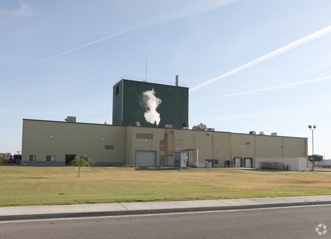
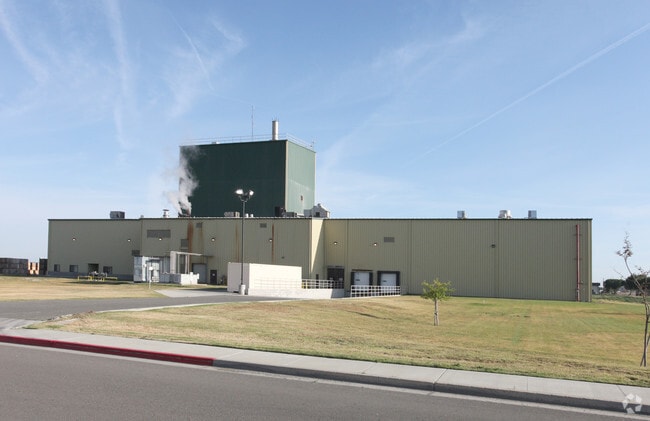
1055 S 19Th Ave, Lemoore, CA 93245

Property Detail
1055 S 19Th Ave
024-051-021-000
1055 S 19TH AVE LEM
Foodprocessing
Kings
ML
California
B and X Area of moderate flood hazard, usually the area between the limits of the 100-year and 500-year floods.
8
2024
14.07 AC
2025
Lemoore
000402
Fresno
31,104 SF
Hanford-Corcoran, CA
NEARBY LISTINGS FOR SALE OR LEASE
DEMOGRAPHICS near 1055 S 19Th Ave
1 mile
3 mile
5 mile
2025 Total Population
4,811
28,924
37,943
2030 Population
4,869
29,164
38,465
Pop Growth 2025-2030
+ 1.21%
+ 0.83%
+ 1.38%
Average Age
36
35
33
2025 Total Households
1,543
9,723
12,204
HH Growth 2025-2030
+ 1.23%
+ 0.82%
+ 1.33%
Median Household Inc
$87,815
$78,054
$75,420
Avg Household Size
3.10
2.90
3.00
2025 Avg HH Vehicles
3.00
2.00
2.00
Median Home Value
$383,911
$353,171
$354,425
Median Year Built
1996
1988
1990
Nearby Places
Map Layers
Map Styles
 Street
 Aerial
Layers
 Traffic
 Biking
Places
Listings with unknown addresses are not visible on the map
- Restaurants
- Banks
- Shops
- Fitness
- Groceries
PUBLIC TRANSPORTATION
COMMUTER RAIL
Drive
Walk
Distance
13 min
9.5 mi
AIRPORT
Fresno Yosemite International
Drive
Walk
Distance
Fresno Yosemite International
51 min
38.2 mi
Nearby Properties
Address
Land Use
TOTAL SIZE
Lot Size
Zoning
Address
Land Use
TOTAL SIZE
Lot Size
Zoning
838,078 SF
60.81 AC
ML
Address
Land Use
TOTAL SIZE
Lot Size
Zoning
4.25 AC
ML
Address
Land Use
TOTAL SIZE
Lot Size
Zoning
2,034 SF
134.56 AC
AG20
Address
Land Use
TOTAL SIZE
Lot Size
Zoning
184,792 SF
11.05 AC
RMD
Address
Land Use
TOTAL SIZE
Lot Size
Zoning
10.45 AC
RHD
Address
Land Use
TOTAL SIZE
Lot Size
Zoning
5.43 AC
RMD
Address
Land Use
TOTAL SIZE
Lot Size
Zoning
46,362 SF
3.83 AC
NC
Address
Land Use
TOTAL SIZE
Lot Size
Zoning
110,190 SF
12.01 AC
RMD
Address
Land Use
TOTAL SIZE
Lot Size
Zoning
2.67 AC
CF
Address
Land Use
TOTAL SIZE
Lot Size
Zoning
194.60 AC
AG20
Address
Land Use
TOTAL SIZE
Lot Size
Zoning
4.70 AC
RHD
Address
Land Use
TOTAL SIZE
Lot Size
Zoning
7.84 AC
RMD
Address
Land Use
TOTAL SIZE
Lot Size
Zoning
Address
Land Use
TOTAL SIZE
Lot Size
Zoning
24.96 AC
ML
Address
Land Use
TOTAL SIZE
Lot Size
Zoning
37,500 SF
31.72 AC
ML
Address
Land Use
TOTAL SIZE
Lot Size
Zoning
3.13 AC
RM3
Address
Land Use
TOTAL SIZE
Lot Size
Zoning
139,680 SF
5.95 AC
RMD
Address
Land Use
TOTAL SIZE
Lot Size
Zoning
103,044 SF
8.82 AC
NC
Address
Land Use
TOTAL SIZE
Lot Size
Zoning
5.32 AC
RMD
Address
Land Use
TOTAL SIZE
Lot Size
Zoning
0.44 AC
DMX-1
Address
Land Use
TOTAL SIZE
Lot Size
Zoning
7.61 AC
NC
Address
Land Use
TOTAL SIZE
Lot Size
Zoning
19,535 SF
2.42 AC
NC
Address
Land Use
TOTAL SIZE
Lot Size
Zoning
2,380 SF
54.11 AC
RLD
Address
Land Use
TOTAL SIZE
Lot Size
Zoning
160 AC
AX
Address
Land Use
TOTAL SIZE
Lot Size
Zoning
4,001 SF
0.84 AC
RC
Address
Land Use
TOTAL SIZE
Lot Size
Zoning
2.20 AC
CH
Address
Land Use
TOTAL SIZE
Lot Size
Zoning
5,349 SF
1.94 AC
RC
Address
Land Use
TOTAL SIZE
Lot Size
Zoning
4,280 SF
1.49 AC
RC
Address
Land Use
TOTAL SIZE
Lot Size
Zoning
17,161 SF
2.01 AC
NC
The World's #1 Commercial Real Estate Marketplace
Connect with us
© 2026 CoStar Group
The information above has been obtained from sources believed reliable. While we do not doubt its accuracy we have not verified it and make no guarantee, warranty or representation about it. It is your responsibility to independently confirm its accuracy and completeness. Any projections, opinions, assumptions, or estimates used are for example only and do not represent the current or future performance of the property. The value of this transaction to you depends on tax and other factors which should be evaluated by your tax, financial, and legal advisors. You and your advisors should conduct a careful, independent investigation of the property to determine to your satisfaction the suitability of the property for your needs.