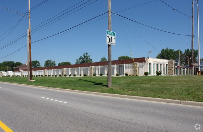
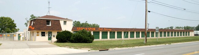
Property Record
1055 W Alexis Rd, Toledo, OH 43612
NEARBY LISTINGS FOR SALE OR LEASE
Property Detail
1055 W Alexis Rd
22-75156
8 9 6 SW 1/4 IRREG PCE PT SW BENORE RD& SE WENDELS SUBDN
Warehouse
Lucas
AE
Ohio
39095C0082G
2.78 AC
2024
North Toledo
2024
Toledo
005704
Toledo, OH
DEMOGRAPHICS near 1055 W Alexis Rd
1 Mile
3 Mile
5 Mile
2024 Total Population
1,618
42,359
134,311
2029 Population
1,664
41,877
134,126
Pop Growth 2024-2029
+ 2.84%
(1.14%)
(0.14%)
Average Age
40
40
39
2024 Total Households
684
17,910
56,543
HH Growth 2024-2029
+ 2.78%
(1.23%)
(0.16%)
Median Household Inc
$47,694
$48,058
$45,097
Avg Household Size
2.40
2.30
2.30
2024 Avg HH Vehicles
2.00
2.00
2.00
Median Home Value
$72,454
$95,742
$102,132
Median Year Built
1977
1958
1954
Nearby Places
Map Layers
Map Styles
 Street
 Aerial
- Restaurants
- Banks
- Shops
- Fitness
- Groceries
PUBLIC TRANSPORTATION
COMMUTER RAIL
Toledo (Capitol Limited - Amtrak, Lake Shore Limited - Amtrak)
DRIVE
WALK
Distance
Toledo (Capitol Limited - Amtrak, Lake Shore Limited - Amtrak)
13 min
8.3 mi
AIRPORT
Eugene F Kranz Toledo Express
DRIVE
WALK
Distance
Eugene F Kranz Toledo Express
43 min
25.9 mi
Freight Ports
Port of Toledo
DRIVE
WALK
Distance
Port of Toledo
19 min
10.0 mi
Nearby Properties
Address
Land Use
TOTAL SIZE
Lot Size
Zoning
Address
Land Use
TOTAL SIZE
Lot Size
Zoning
169.42 AC
10-IG
Address
Land Use
TOTAL SIZE
Lot Size
Zoning
1,972,579 SF
76.32 AC
10-IG
Address
Land Use
TOTAL SIZE
Lot Size
Zoning
693,900 SF
76.32 AC
10-IG
Address
Land Use
TOTAL SIZE
Lot Size
Zoning
Address
Land Use
TOTAL SIZE
Lot Size
Zoning
76.32 AC
10-IG
Address
Land Use
TOTAL SIZE
Lot Size
Zoning
169.42 AC
10-IG
Address
Land Use
TOTAL SIZE
Lot Size
Zoning
33.48 AC
10-IG
Address
Land Use
TOTAL SIZE
Lot Size
Zoning
163,962 SF
10.13 AC
Address
Land Use
TOTAL SIZE
Lot Size
Zoning
450,000 SF
37.30 AC
Address
Land Use
TOTAL SIZE
Lot Size
Zoning
18.70 AC
Address
Land Use
TOTAL SIZE
Lot Size
Zoning
230,400 SF
18 AC
10-CR
Address
Land Use
TOTAL SIZE
Lot Size
Zoning
90,113 SF
8.12 AC
21-PO
Address
Land Use
TOTAL SIZE
Lot Size
Zoning
Address
Land Use
TOTAL SIZE
Lot Size
Zoning
84,527 SF
7.79 AC
10-RS6
Address
Land Use
TOTAL SIZE
Lot Size
Zoning
47,600 SF
5.04 AC
Address
Land Use
TOTAL SIZE
Lot Size
Zoning
20.67 AC
10-MX
Address
Land Use
TOTAL SIZE
Lot Size
Zoning
159,798 SF
8.32 AC
10-IL
Address
Land Use
TOTAL SIZE
Lot Size
Zoning
175,978 SF
10.02 AC
10-IL
Address
Land Use
TOTAL SIZE
Lot Size
Zoning
328,898 SF
13.67 AC
10-IG
Address
Land Use
TOTAL SIZE
Lot Size
Zoning
302,338 SF
13.97 AC
Address
Land Use
TOTAL SIZE
Lot Size
Zoning
117,635 SF
5.30 AC
Address
Land Use
TOTAL SIZE
Lot Size
Zoning
90,507 SF
9 AC
10-CRSO
Address
Land Use
TOTAL SIZE
Lot Size
Zoning
106.75 AC
AC = AG
Address
Land Use
TOTAL SIZE
Lot Size
Zoning
92,888 SF
20.24 AC
10-IL
Address
Land Use
TOTAL SIZE
Lot Size
Zoning
123,258 SF
23.59 AC
Address
Land Use
TOTAL SIZE
Lot Size
Zoning
86.45 AC
10-IG
Address
Land Use
TOTAL SIZE
Lot Size
Zoning
125,840 SF
10.50 AC
Address
Land Use
TOTAL SIZE
Lot Size
Zoning
132,601 SF
14.41 AC
10-MX
Address
Land Use
TOTAL SIZE
Lot Size
Zoning
28.51 AC
10-IG
Address
Land Use
TOTAL SIZE
Lot Size
Zoning
191,297 SF
28.74 AC
10-CRSO
The World's #1 Commercial Real Estate Marketplace
Connect with us
© 2025 CoStar Group
The information above has been obtained from sources believed reliable. While we do not doubt its accuracy we have not verified it and make no guarantee, warranty or representation about it. It is your responsibility to independently confirm its accuracy and completeness. Any projections, opinions, assumptions, or estimates used are for example only and do not represent the current or future performance of the property. The value of this transaction to you depends on tax and other factors which should be evaluated by your tax, financial, and legal advisors. You and your advisors should conduct a careful, independent investigation of the property to determine to your satisfaction the suitability of the property for your needs.