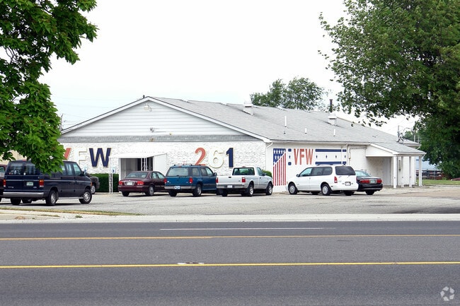
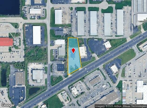
Property Record
10550 Pendleton Pike, Indianapolis, IN 46236

NEARBY LISTINGS FOR SALE OR LEASE
-
-
View all Indianapolis listings for sale on LoopNet.com
Property Detail
10550 Pendleton Pike
49-08-04-128-015.000-407
PT W1/2 SE1/4 S4 T16 R5 BEG 1042.27 S & 682.77NW OF NE COR SE 363.93 SW 193.81 N 463.82 E117.6 TO BEG 1.386AC
Taxexempt
Marion
X
Indiana
18097C0180F
1.39 AC
2023
North Shadeland
2024
Indianapolis
330204
Indianapolis-Carmel-Greenwood, IN
5,000 SF
DEMOGRAPHICS near 10550 Pendleton Pike
1 Mile
3 Mile
5 Mile
2024 Total Population
6,693
65,593
158,863
2029 Population
6,540
65,247
158,404
Pop Growth 2024-2029
(2.29%)
(0.53%)
(0.29%)
Average Age
38
36
37
2024 Total Households
2,500
24,354
61,382
HH Growth 2024-2029
(2.36%)
(0.55%)
(0.38%)
Median Household Inc
$70,085
$57,627
$63,375
Avg Household Size
2.60
2.60
2.50
2024 Avg HH Vehicles
2.00
2.00
2.00
Median Home Value
$154,176
$171,879
$198,060
Median Year Built
1995
1989
1982
Nearby Places
Map Layers
Map Styles
 Street
 Aerial
- Restaurants
- Banks
- Shops
- Fitness
- Groceries
PUBLIC TRANSPORTATION
AIRPORT
Indianapolis International
DRIVE
WALK
Distance
Indianapolis International
46 min
26.5 mi
Freight Ports
Port of Toledo
DRIVE
WALK
Distance
Port of Toledo
257 min
212.5 mi
Nearby Properties
Address
Land Use
TOTAL SIZE
Lot Size
Zoning
Address
Land Use
TOTAL SIZE
Lot Size
Zoning
77.34 AC
Address
Land Use
TOTAL SIZE
Lot Size
Zoning
67.17 AC
Address
Land Use
TOTAL SIZE
Lot Size
Zoning
67.09 AC
Address
Land Use
TOTAL SIZE
Lot Size
Zoning
11,154 SF
21.99 AC
Address
Land Use
TOTAL SIZE
Lot Size
Zoning
2,620 SF
32.36 AC
Address
Land Use
TOTAL SIZE
Lot Size
Zoning
532,932 SF
61.88 AC
ZO03
Address
Land Use
TOTAL SIZE
Lot Size
Zoning
2,556 SF
35.56 AC
ZO01
Address
Land Use
TOTAL SIZE
Lot Size
Zoning
4,217 SF
7.37 AC
ZO01
Address
Land Use
TOTAL SIZE
Lot Size
Zoning
129,608 SF
54.85 AC
ZO01
Address
Land Use
TOTAL SIZE
Lot Size
Zoning
2,232 SF
22.88 AC
Address
Land Use
TOTAL SIZE
Lot Size
Zoning
136,336 SF
8.74 AC
ZO01
Address
Land Use
TOTAL SIZE
Lot Size
Zoning
24.25 AC
Address
Land Use
TOTAL SIZE
Lot Size
Zoning
1,769 SF
18.27 AC
Address
Land Use
TOTAL SIZE
Lot Size
Zoning
2,151 SF
11.05 AC
Address
Land Use
TOTAL SIZE
Lot Size
Zoning
293,952 SF
12.88 AC
ZO01
Address
Land Use
TOTAL SIZE
Lot Size
Zoning
65,095 SF
4.06 AC
ZO01
Address
Land Use
TOTAL SIZE
Lot Size
Zoning
245,200 SF
12.08 AC
Address
Land Use
TOTAL SIZE
Lot Size
Zoning
31.13 AC
Address
Land Use
TOTAL SIZE
Lot Size
Zoning
109,200 SF
4.63 AC
ZO01
Address
Land Use
TOTAL SIZE
Lot Size
Zoning
192,246 SF
27.51 AC
Address
Land Use
TOTAL SIZE
Lot Size
Zoning
203,720 SF
21.44 AC
Address
Land Use
TOTAL SIZE
Lot Size
Zoning
4,878 SF
25.65 AC
Address
Land Use
TOTAL SIZE
Lot Size
Zoning
33,588 SF
3.06 AC
ZO01
Address
Land Use
TOTAL SIZE
Lot Size
Zoning
65,541 SF
3.28 AC
ZO01
Address
Land Use
TOTAL SIZE
Lot Size
Zoning
8,386 SF
19.85 AC
Address
Land Use
TOTAL SIZE
Lot Size
Zoning
175,610 SF
23.65 AC
ZO01
Address
Land Use
TOTAL SIZE
Lot Size
Zoning
53,987 SF
2.39 AC
ZO01
Address
Land Use
TOTAL SIZE
Lot Size
Zoning
109,925 SF
9.23 AC
ZO01
Address
Land Use
TOTAL SIZE
Lot Size
Zoning
4,152 SF
19.23 AC
ZO01
Address
Land Use
TOTAL SIZE
Lot Size
Zoning
12,162 SF
18.76 AC
The World's #1 Commercial Real Estate Marketplace
Connect with us
© 2026 CoStar Group
The information above has been obtained from sources believed reliable. While we do not doubt its accuracy we have not verified it and make no guarantee, warranty or representation about it. It is your responsibility to independently confirm its accuracy and completeness. Any projections, opinions, assumptions, or estimates used are for example only and do not represent the current or future performance of the property. The value of this transaction to you depends on tax and other factors which should be evaluated by your tax, financial, and legal advisors. You and your advisors should conduct a careful, independent investigation of the property to determine to your satisfaction the suitability of the property for your needs.